
-
Federal
TOVS GLA MONTHLY GRIDS from NOAA-10 V01 (TOVSAMNG) at GES DISC
National Aeronautics and Space Administration —
This dataset (TOVSAMNG) contains the TIROS Operational Vertical Sounder (TOVS) level 3 geophysical parameters derived using data from NOAA-10 and the physical... -
Federal
MLS/Aura Level 3 Daily Binned Cloud Ice (IWC) on Zonal and Similar Grids V005 (ML3DZIWC) at GES DISC
National Aeronautics and Space Administration —
ML3DZIWC is the EOS Aura Microwave Limb Sounder (MLS) daily binned on zonal and assorted vertical grids product for cloud ice water content (IWC) derived from... -
Federal
SMMR/Nimbus-7 Color Images V001 (SMMRN7IM) at GES DISC
National Aeronautics and Space Administration —
SMMRN7IM is the Nimbus-7 Scanning Multichannel Microwave Radiometer (SMMR) Color Image data product scanned from 17" x 15" color prints and saved as JPEG-2000 files.... -
Federal
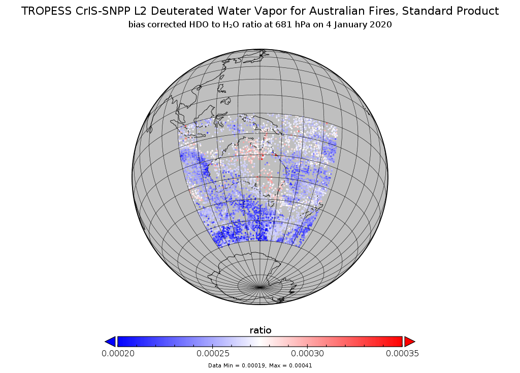
TROPESS CrIS-SNPP L2 Deuterated Water Vapor for Australian Fires, Standard Product V1 (TRPSDL2HDOCRSAUS) at GES DISC
National Aeronautics and Space Administration —
The TROPESS CrIS-SNPP L2 Deuterated Water Vapor for Australian Fires, Standard Product contains the vertical distribution of the retrieved atmospheric state of semi-... -
Federal
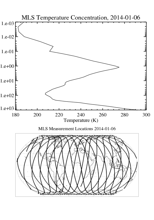
MLS/Aura Level 2 Temperature V004 (ML2T) at GES DISC
National Aeronautics and Space Administration —
ML2T is the EOS Aura Microwave Limb Sounder (MLS) standard product for temperature derived from radiances measured by the 118 and 240 GHz radiometers. The data... -
Federal
TROPICS06 Pathfinder L2B Instantaneous Surface Rain Rate (ISRR) V1.0
National Aeronautics and Space Administration —
The "Time-Resolved Observations of Precipitation structure and storm Intensity with a Constellation of Smallsats" (TROPICS) mission has a goal of providing nearly... -
Federal
Sounder SIPS: Suomi NPP CrIMSS Level 2 CLIMCAPS Full Spectral Resolution: Atmosphere cloud and surface geophysical state V2 (SNDRSNIML2CCPRET) at GES DISC
National Aeronautics and Space Administration —
WARNING: To users of the derived product “co_mmr_midtrop” (carbon monoxide mass mixing ratio to dry air [kg/kg] at ~500 hPa). This variable has a significant bias due... -
Federal
MLS/Aura Level 3 Daily Binned Geopotential Height (GPH) on Assorted Grids V005 (ML3DBGPH) at GES DISC
National Aeronautics and Space Administration —
ML3DBGPH is the EOS Aura Microwave Limb Sounder (MLS) daily binned on various vertical grids product for geopotential height (GPH) derived from radiances measured by... -
Federal
Sentinel-5P TROPOMI Near-Real-Time (NRT) Radiance product band 4 (UVIS detector) L1B 5.5km x 3.5km V2 (S5P_L1B_RA_BD4_HiR_NRT) at GES DISC
National Aeronautics and Space Administration —
The Sentinel-5P TROPOMI Near Real Time (NRT) Radiance product band 4 (UVIS detector) L1B 5.5km x 21km V2 (S5P_L1B_RA_BD4_HiR_NRT) product at GES DISC is the near real... -
Federal
TROPICS06 L2B Neural-network Atmospheric Vertical Temperature & Moisture Profiles V1.0
National Aeronautics and Space Administration —
The "Time-Resolved Observations of Precipitation structure and storm Intensity with a Constellation of Smallsats" (TROPICS) mission has a goal of providing nearly... -
Federal
MLS/Aura Level 3 Monthly Binned Geopotential Height (GPH) on Assorted Grids V005 (ML3MBGPH) at GES DISC
National Aeronautics and Space Administration —
ML3MBGPH is the EOS Aura Microwave Limb Sounder (MLS) monthly binned on various vertical grids product for geopotential height (GPH) derived from radiances measured... -
Federal
NASA MEASURES Precipitation Ensemble based on SSM/I DMSP F10 NASA PPS L1C V06 Tbs 1-orbit L2 Swath 12x12km V1 (PRECIP_SSMI_F10) at GES DISC
National Aeronautics and Space Administration —
The data presented in this level 2 orbital product are rain rate estimates expressed as mm/hour determined from brightness temperatures (Tbs) obtained from the... -
Federal
AIRS/Aqua L1B Near Real Time (NRT) Infrared (IR) quality assurance subset V005 (AIRIBQAP_NRT) at GES DISC
National Aeronautics and Space Administration —
The AIRS Level 1B Near Real Time (NRT) product (AIRIBQAP_NRT_005) differs from the routine product (AIRIBQAP_005) in 2 ways to meet the three hour latency... -
Federal
AIRS/Aqua L1B Near Real Time (NRT) Infrared (IR) geolocated and calibrated radiances V005 (AIRIBRAD_NRT) at GES DISC
National Aeronautics and Space Administration —
WARNING: On 2021/09/23 the EOS Aqua executed a Deep Space Maneuver (DSM). In the DSM, the spacecraft is turned such that the normal Earth field of regard is deep... -
Federal
MERRA-2 const_2d_lnd_Nx: 2d, constants Land Surface Diagnostics 0.625 x 0.5 degree V5.12.4 (M2C0NXLND) at GES DISC
National Aeronautics and Space Administration —
M2C0NXLND (or const_2d_lnd_Nx) is a data collection in Modern-Era Retrospective analysis for Research and Applications version 2 (MERRA-2). This collection consists... -
Federal
OCO-3 Level 2 spatially ordered geolocated retrievals screened using the IMAP-DOAS Preprocessor (IDP), Forward Processing V11 (OCO3_L2_IMAPDOAS) at GES DISC
National Aeronautics and Space Administration —
Version 11 is the current version of the data set. Older versions will no longer be available and are superseded by Version 11. The Orbiting Carbon Observatory -3... -
Federal
MLS/Aura Level 3 Daily Binned Chlorine Monoxide (ClO) Mixing Ratio on Zonal and Similar Grids V004 (ML3DZCLO) at GES DISC
National Aeronautics and Space Administration —
ML3DZCLO is the EOS Aura Microwave Limb Sounder (MLS) daily binned on zonal and assorted vertical grids product for chlorine monoxide (ClO) derived from radiances... -
Federal
GPM SSMIS on F18 (GPROF) Radiometer Precipitation Profiling L2 1.5 hours 12 km V07 (GPM_2AGPROFF18SSMIS) at GES DISC
National Aeronautics and Space Administration —
Version 07 is the current version of the data set. Older versions will no longer be available and have been superseded by Version 07. The 2AGPROF (Goddard Profiling)... -
Federal
HRIR/Nimbus-2 Level 1 Meteorological Radiation Data V001 (HRIRN2L1) at GES DISC
National Aeronautics and Space Administration —
HRIRN2L1 is the High Resolution Infrared Radiometer (HRIR) Nimbus-2 Level 1 Meteorological Radiance Data (NMRT) product and contains infrared radiances converted to... -
Federal
TROPESS CrIS-JPSS1 L2 Carbon Monoxide for Forward Stream, Summary Product V1 (TRPSYL2COCRS1FS) at GES DISC
National Aeronautics and Space Administration —
The TROPESS CrIS-JPSS1 L2 Carbon Monoxide for Forward Stream, Summary Product contains the vertical distribution of the retrieved atmospheric state of carbon monoxide...

Official websites use .gov
A
.gov website belongs to an official government
organization in the United States.
Secure .gov websites use HTTPS
A
lock (
) or https:// means you’ve safely connected to
the .gov website. Share sensitive information only on official,
secure websites.