
-
Federal
AQUA MODIS High Resolution Level 3 monthly aerosol data, 0.1x0.1 degree grid Version 001 (AER_DBDT_M10KM_L3_MODIS_AQUA) at GES DISC
National Aeronautics and Space Administration —
This High-Resolution (0.1 x 0.1 degree) Level 3 monthly Aerosol Optical Depth (AOD) product is generated by combining two Moderate Resolution Imaging... -
Federal
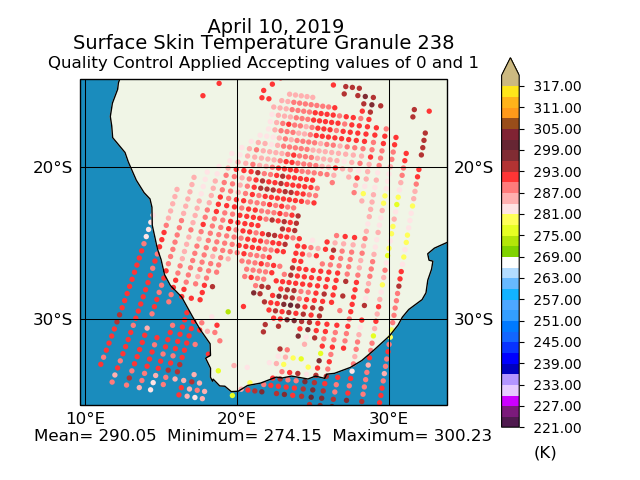
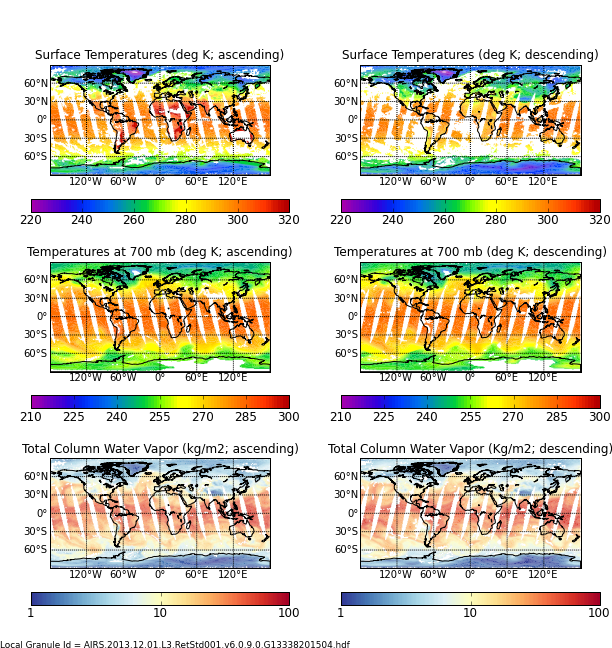
Aqua/AIRS L2 Support Retrieval (AIRS-only) V7.0 at GES DISC
National Aeronautics and Space Administration —
The Atmospheric Infrared Sounder (AIRS) is a grating spectrometer (R = 1200) aboard the second Earth Observing System (EOS) polar-orbiting platform, EOS Aqua. In... -
Federal
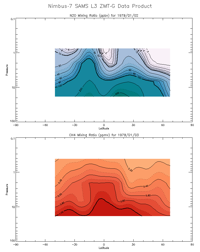
SAMS/Nimbus-7 Level 3 Zonal Means Composition Data V001 (SAMSN7L3ZMTG) at GES DISC
National Aeronautics and Space Administration —
SAMSN7L3ZMTG is the Nimbus-7 Stratospheric and Mesospheric Sounder (SAMS) Level 3 Zonal Means Composition Data Product. The Earth's surface is divided into 2.5-deg... -
Federal
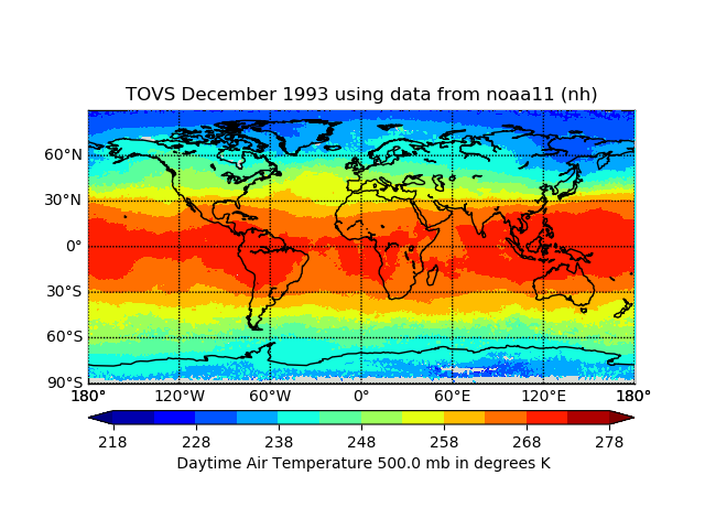
TOVS GLA MONTHLY GRIDS from NOAA-11 02 (TOVSAMNH) at GES DISC
National Aeronautics and Space Administration —
This dataset (TOVSAMNH) contains the TIROS Operational Vertical Sounder (TOVS) level 3 geophysical parameters derived using data from NOAA-11 and the physical... -
Federal
TRMM Ground Validation Radar Site 3D Rain Map L3 1 month 2 km V7 (TRMM_3A55) at GES DISC
National Aeronautics and Space Administration —
The 3A55, 'Monthly 3-D Structure', provides radar site monthly 3-D structure information obtained from 2A55. The 2A55 'Radar Site 3-D Reflectivities', is composed of... -
Federal
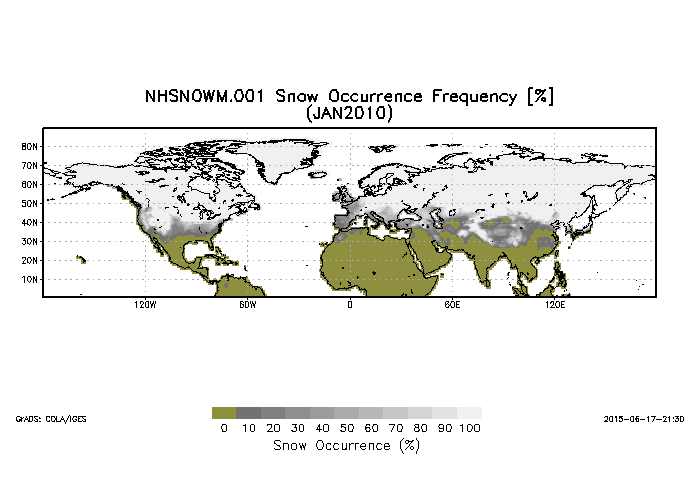
Northern Hemisphere Snow Cover Monthly Statistics at 1 Degree Resolution V001 (NHSNOWM) at GES DISC
National Aeronautics and Space Administration —
This product is Snow Cover Statistics. The dataset was prepared by Dr. Peter Romanov at Cooperative Institute for Climate Studies(CICS) of the University of Maryland... -
Federal
AIRS/Aqua L1B AMSU (A1/A2) geolocated and calibrated brightness temperatures V005 (AIRABRAD) at GES DISC
National Aeronautics and Space Administration —
The Atmospheric Infrared Sounder (AIRS) is a grating spectrometer (R = 1200) aboard the second Earth Observing System (EOS) polar-orbiting platform, EOS Aqua. In... -
Federal
TROPESS CrIS-SNPP L2 Carbon Monoxide for West Coast Fires HiRes, Standard Product V1 (TRPSDL2COCRSWCFHI) at GES DISC
National Aeronautics and Space Administration —
The TROPESS CrIS-SNPP L2 Carbon Monoxide for West Coast Fires HiRes, Standard Product contains the vertical distribution of the retrieved atmospheric state of carbon... -
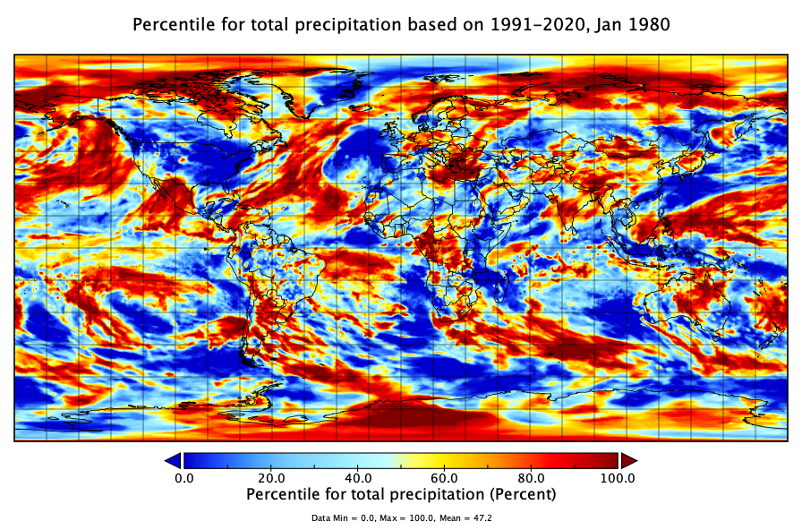
Federal
MERRA-2 statM_2d_pct_Nx: 2d, Single-Level, Monthly Percentiles based on 1991-2020 V2 (M2SMNXPCT) at GES DISC
National Aeronautics and Space Administration —
M2SMNXPCT (or statM_2d_pct_Nx) is a 2-dimensional monthly data collection for percentile statistics derived from monthly Modern-Era Retrospective analysis for... -
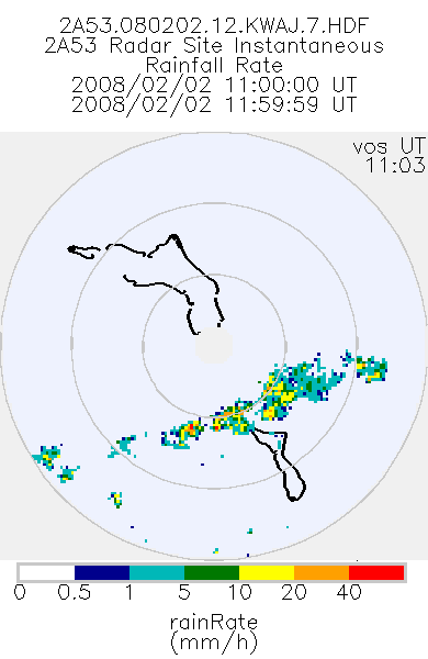
Federal
TRMM Ground Validation Radar Site Rain Rate Map L2 1 hour 2 km V7 (TRMM_2A53UW) at GES DISC
National Aeronautics and Space Administration —
This dataset is part of the University of Washington TRMM Ground Validation products. Instantaneous rain rate cartesian grid based on baseUW and 2A54UW. Units are... -
Federal
MLS/Aura Level 3 Monthly Binned Chlorine Monoxide (ClO) Mixing Ratio on Assorted Grids V005 (ML3MBCLO) at GES DISC
National Aeronautics and Space Administration —
ML3MBCLO is the EOS Aura Microwave Limb Sounder (MLS) monthly binned on various vertical grids product for chlorine monoxide (ClO) derived from radiances measured... -
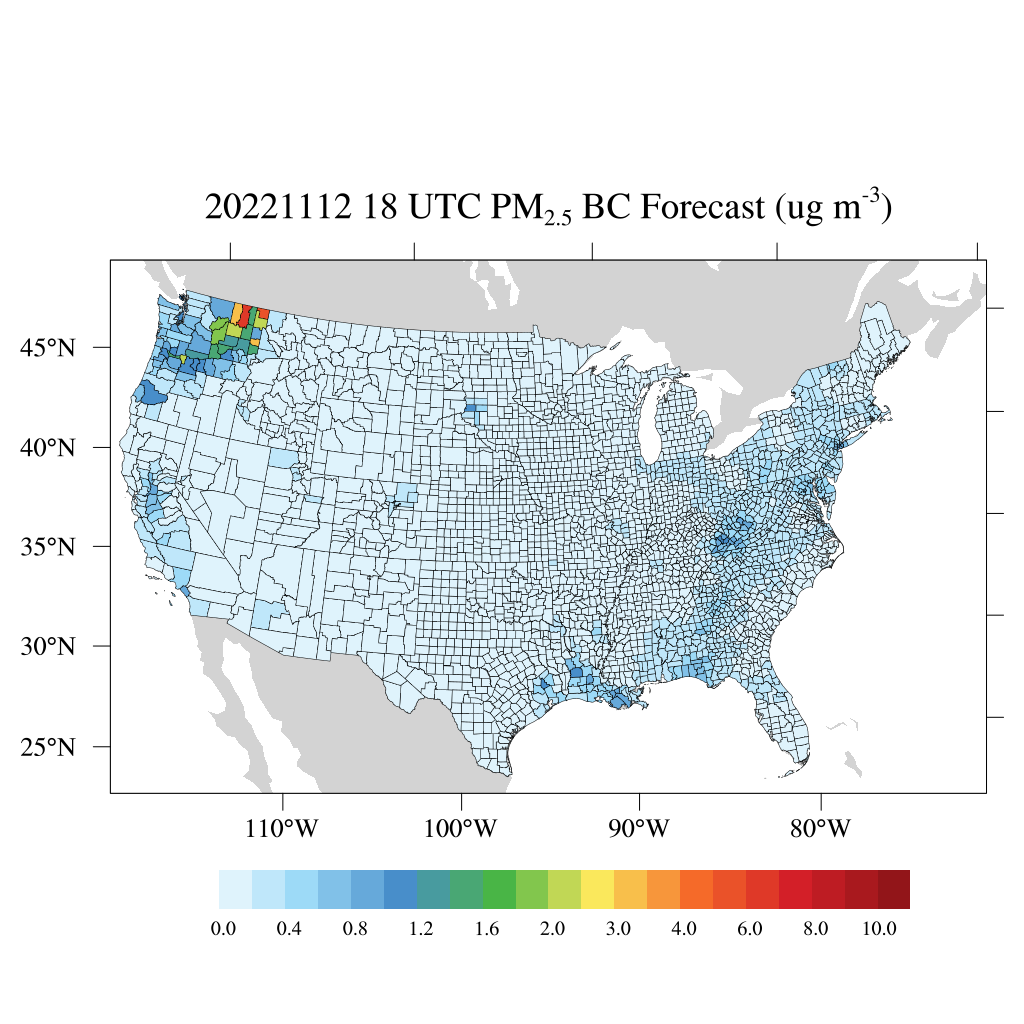
Federal
HAQES 3-Hourly Ensemble mean surface PM2.5 Black Carbon concentration at county level, North America V1 (HAQES_NA_PM25_BC_COUNTY) at GES DISC
National Aeronautics and Space Administration —
This product provides HAQES 3-hourly ensemble mean surface PM2.5 Black Carbon concentration at the county level over the continental United States (CONUS). The... -
Federal
Sounder SIPS: JPSS-1 ATMS Level 3 RAMSES2 Standard Gridded Monthly V3 at GES DISC
National Aeronautics and Space Administration —
This level 3 monthly product is generated from the RAMSES (Retrieval Algorithm for Microwave Sounders in Earth Science) II algorithm.The RAMSES II algorithm is a... -
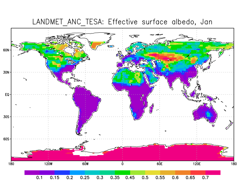
Federal
LANDMET Ancillary Monthly Mean Effective and Spectral Albedo Data L3 V1 (LANDMET_ANC_TESA) at GES DISC
National Aeronautics and Space Administration —
This is an ancillary product containing the total effective surface albedo at solar wavelengths originated from the ISCCP FD radiative fluxes product, and the... -
Federal
GPM SSMIS on F17 Common Calibrated Brightness Temperatures L1C 1.5 hours 12 km V07 (GPM_1CF17SSMIS) at GES DISC
National Aeronautics and Space Administration —
Version 07 is the current version of the data set. Older versions will no longer be available and have been superseded by Version 07. All 1C products have a common... -
Federal
OCO-3 Level 2 geolocated XCO2 retrieval results and algorithm diagnostic information, Forward Processing V10 (OCO3_L2_Diagnostic) at GES DISC
National Aeronautics and Space Administration —
Version 10 is the current version of the data set. Older versions will no longer be available and are superseded by Version 10. The Orbiting Carbon Observatory -3... -
Federal
AIRS/Aqua L3 Daily Support Product (AIRS-only) 1 degree x 1 degree V006 (AIRS3SPD) at GES DISC
National Aeronautics and Space Administration —
The Atmospheric Infrared Sounder (AIRS) is a grating spectrometer (R = 1200) aboard the second Earth Observing System (EOS) polar-orbiting platform, EOS Aqua. In... -
Federal
OCO-2 Level 2 geolocated XCO2 retrieval results and algorithm diagnostic information, Retrospective Processing V11r (OCO2_L2_Diagnostic) at GES DISC
National Aeronautics and Space Administration —
Version 11r is the current version of the data set. Older versions will no longer be available and are superseded by Version 11r. The Orbiting Carbon Observatory is... -
Federal
GPM ATMS on SUOMI-NPP (GPROF) Radiometer Precipitation Profiling L3 1 day 0.25 degree x 0.25 degree V07 (GPM_3GPROFNPPATMS_DAY_CLIM) at GES DISC
National Aeronautics and Space Administration —
Version 07 is the current version of the data set. Older versions are no longer available and have been superseded by Version 07. The "CLIM" products differ from... -
Federal
GPM MHS on METOP-A (GPROF) Radiometer Precipitation Profiling L3 1 month 0.25 degree x 0.25 degree V07 (GPM_3GPROFMETOPAMHS_CLIM) at GES DISC
National Aeronautics and Space Administration —
Version 07 is the current version of the data set. Older versions are no longer available and have been superseded by Version 07. The "CLIM" products differ from...

Official websites use .gov
A
.gov website belongs to an official government
organization in the United States.
Secure .gov websites use HTTPS
A
lock (
) or https:// means you’ve safely connected to
the .gov website. Share sensitive information only on official,
secure websites.