
-
County
Pittsburgh PLI/DOMI Violations Report
Allegheny County / City of Pittsburgh / Western PA Regional Data Center —
This dataset originally housed Department of Permits, Licenses, and Inspections violations (2015-2020), and has now been expanded to include violations logged by... -
Federal
GLDAS Noah Land Surface Model L4 3 hourly 0.25 x 0.25 degree V2.0 (GLDAS_NOAH025_3H) at GES DISC
National Aeronautics and Space Administration —
NASA Global Land Data Assimilation System Version 2 (GLDAS-2) has three components: GLDAS-2.0, GLDAS-2.1, and GLDAS-2.2. GLDAS-2.0 is forced entirely with the... -
Federal
BLM Natl AIM LMF Public Geodatabase
Department of the Interior —
This dataset was created to monitor the status, condition and trend of national BLM resources in accordance with BLM policies. It focuses on the BLM terrestrial core... -
Federal
Centipod WEC, Advanced Controls, Resultant LCOE
Department of Energy —
Project resultant levelized cost of energy (LCOE) model after implementation of model predictive control (MPC) controller. Contains annual energy production (AEP)... -
ACS 5-Year Demographic Characteristics DC Census Tract
District of Columbia —
Age, Sex, Race, Ethnicity, Total Housing Units, and Voting Age Population. This service is updated annually with American Community Survey (ACS) 5-year data. Contact:... -
Federal
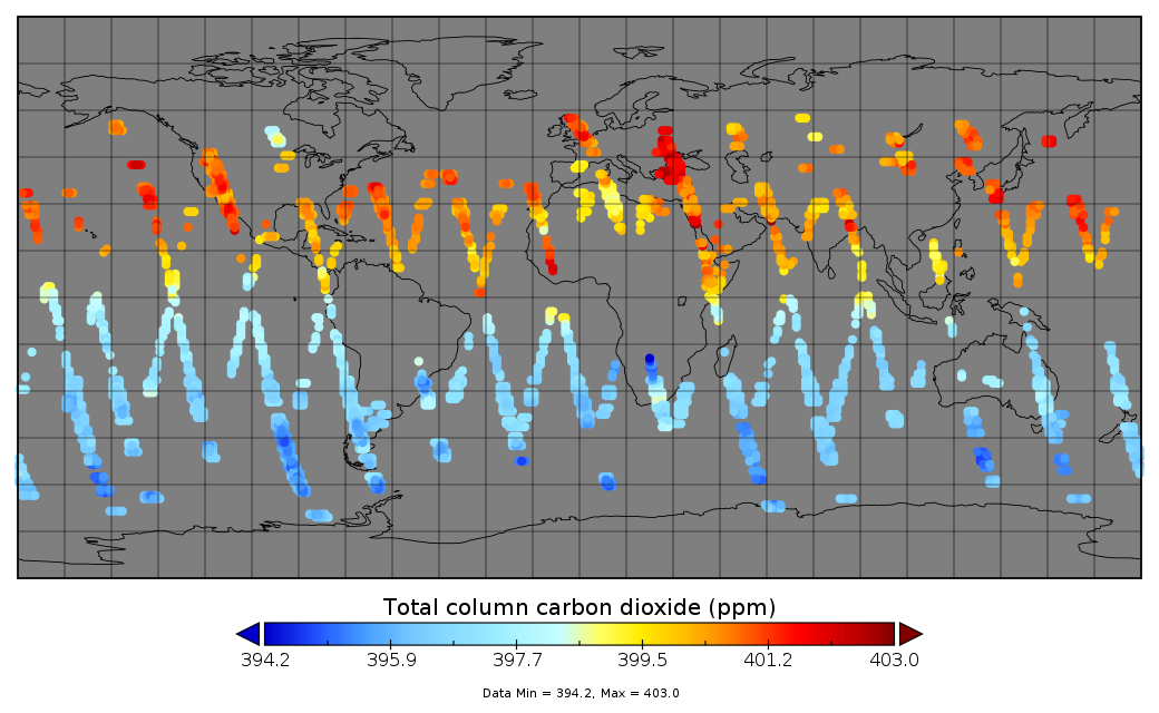
Multi-Instrument Fused bias-corrected XCO2 and other select fields aggregated as Level 4 daily files V3 (MultiInstrumentFusedXCO2)
National Aeronautics and Space Administration —
Gridded carbon dioxide mole fraction (XCO2) and other select variables created by applying local kriging (also known as optimal interpolation) to daily aggregates of... -
City
Water Mains
City of Seattle —
A grouped feature layer that includes Water Mains, Water Services, Same Side Tap Only and No New Taps layers.Water Mains are large buried pipes that distribute water... -
Federal
Carbon dioxide, hydrographic and chemical data collected from profile discrete samples during the R/V Knorr cruise (EXPOCODE 316N20071003) in Davis Strait from 2007-10-03 to 2007-10-21 (NCEI Accession 0173248)
National Oceanic and Atmospheric Administration, Department of Commerce —
This dataset includes profile discrete measurements of CTD temperature, CTD salinity, CTD oxygen, nutrients, dissolved inorganic carbon, total alkalinity other... -
City
BPD Arrests
City of Baltimore —
This dataset represents arrests made by the Baltimore Police Department. Data are updated weekly. To leave feedback or ask a question about this dataset, please fill... -
State
CA Zip Code Boundaries
State of California —
This feature service is derived from the Esri "United States Zip Code Boundaries" layer, queried to only CA data.For the original data see:... -
State
Fault Lines
State of Oregon —
This dataset represents structural faults (at the scale of original mapping) and descriptive data and shows the location and type of faults in the state of Oregon.... -
County
King County Parcel Viewer
King County, Washington —
Parcel Viewer makes searching for King County parcel information easy. You can search by address, search by parcel number, or you can just zoom in on the map and... -
Construction Permits in 2026
District of Columbia —
The dataset contains locations and attributes of above ground permits applied for and approved by the District Department of Transportation. They are newly occupied... -
City
Kentucky Soils
Louisville Metro Government —
Data from the US Department of Agriculture - Natural Resources Conservation Services that is residing in the Kentucky Geonet FTP server maintained by Division of... -
City
Coming Soon
City of Tempe —
This page is a holding place for performance measures with pending content. -
Federal
Multibeam collection for SR1904: Multibeam data collected aboard Sally Ride from 05-Mar-19 to 07-Mar-19, Alameda, California to San Diego, California
National Oceanic and Atmospheric Administration, Department of Commerce —
This data set is part of a larger set of data called the Multibeam Bathymetry Database (MBBDB) where other similar data can be found -
Federal
Multibeam collection for COOK04MV: Multibeam data collected aboard Melville from 11-Nov-00 to 22-Dec-00, Papeete, French Polynesia to Apia, Western Samoa
National Oceanic and Atmospheric Administration, Department of Commerce —
This data set is part of a larger set of data called the Multibeam Bathymetry Database (MBBDB) where other similar data can be found -
Federal
L00329: NOS Hydrographic Survey
National Oceanic and Atmospheric Administration, Department of Commerce —
The National Oceanic and Atmospheric Administration (NOAA) has the statutory mandate to collect hydrographic data in support of nautical chart compilation for safe... -
Federal
Multibeam collection for NF-06-04-SEA: Multibeam data collected aboard NOAA Ship NANCY FOSTER (R352) from 05-Apr-06 to 15-Apr-06, San Juan, Puerto Rico to San Juan, Puerto Rico
National Oceanic and Atmospheric Administration, Department of Commerce —
This data set is part of a larger set of data called the Multibeam Bathymetry Database (MBBDB) where other similar data can be found

Official websites use .gov
A
.gov website belongs to an official government
organization in the United States.
Secure .gov websites use HTTPS
A
lock (
) or https:// means you’ve safely connected to
the .gov website. Share sensitive information only on official,
secure websites.