
-
Federal
EK80 Water Column Sonar Data Collected During AR34A
National Oceanic and Atmospheric Administration, Department of Commerce —
OOI Pioneer Array -
Federal
Loop Current Observations in the Eastern Gulf of Mexico - SAIC Mooring Data (Currents)
National Oceanic and Atmospheric Administration, Department of Commerce —
Phsyical Oceanographic Circulation Study -
Federal
Loop Current Observations in the Eastern Gulf of Mexico - PIES Data
National Oceanic and Atmospheric Administration, Department of Commerce —
Phsyical Oceanographic Circulation Study -
Federal
ROSETTA-ORBITER LUTETIA ROSINA 2 AST2 V1.0
National Aeronautics and Space Administration —
This data set present engineering data of the COPS, DFMS and RTOF ROSINA sensors during the Lutetia flyby phase -
Federal
EK80 Water Column Sonar Data Collected During SR1917
National Oceanic and Atmospheric Administration, Department of Commerce —
Investigating Diazotrophy in tropical and subtropical Pacific Ocean -
Federal
Gulf of Mexico Currents CICESE Mooring E5 NORTEK A3L AT 1806M delta_t 360 (20090606-20100420)
National Oceanic and Atmospheric Administration, Department of Commerce —
Phsyical Oceanographic Circulation Study -
Federal
Eastern Gulf of Mexico Circulation Study
National Oceanic and Atmospheric Administration, Department of Commerce —
Phsyical Oceanographic Circulation Study -
Federal
ROSETTA-ORBITER CHECK GIADA 2 MARS MARSSWINGBY V1.0
National Aeronautics and Space Administration —
This volume contains Experiment Data acquired by GIADA during 'Mars swing-by' phase. More in detail it refers to the data provided during the following in-flight... -
Federal
EK80 Water Column Sonar Data Collected During SR1907
National Oceanic and Atmospheric Administration, Department of Commerce —
Student Cruises for Marine Biology -
Federal
Gulf of Mexico Currents CICESE Mooring Y6 RCM11 AT 1870 M delta_t 60 (20090604-20110511)
National Oceanic and Atmospheric Administration, Department of Commerce —
Phsyical Oceanographic Circulation Study -
Federal
Gulf of Mexico Currents CICESE Mooring N4 NORTEK A3L AT 2295M delta_t 360 (20090605-20100409)
National Oceanic and Atmospheric Administration, Department of Commerce —
Phsyical Oceanographic Circulation Study -
Federal
MPFR MARS ROVER CAMERA 5 MOSAICKED IMAGE DATA RECORD V1.0
National Aeronautics and Space Administration —
Mars Pathfinder bounced down and rolled to a stop on the surface of Mars on July 4, 1997. After a slight delay in deployment due to airbags draped over one of the... -
Federal
Gulf of Mexico Currents CICESE Mooring Y6 RCM11 AT 1870 M delta_t 30 (20100417-20110511)
National Oceanic and Atmospheric Administration, Department of Commerce —
Phsyical Oceanographic Circulation Study -
Federal
Gulf of Mexico Scalars CICESE Mooring Y6 RCM11 AT 1870 M delta_t 30 (20100417-20110511)
National Oceanic and Atmospheric Administration, Department of Commerce —
Phsyical Oceanographic Circulation Study -
Federal
Gulf of Mexico Scalars CICESE Mooring Y5 RCM11 AT 1189 M delta_t 15 (20100418-20110511)
National Oceanic and Atmospheric Administration, Department of Commerce —
Phsyical Oceanographic Circulation Study -
Federal
Gulf of Mexico Currents CICESE Mooring Y6 RCM11 AT 1050 M delta_t 30 (20100417-20110511)
National Oceanic and Atmospheric Administration, Department of Commerce —
Phsyical Oceanographic Circulation Study -
Federal
EK60 Water Column Sonar Data Collected During EX2302
National Oceanic and Atmospheric Administration, Department of Commerce —
From May 5 â 26, 2023 (Seattle, Washington, to Dutch Harbor, Alaska), NOAA Ocean Exploration conducted transit and mapping operations off the coast of Washington... -
Federal
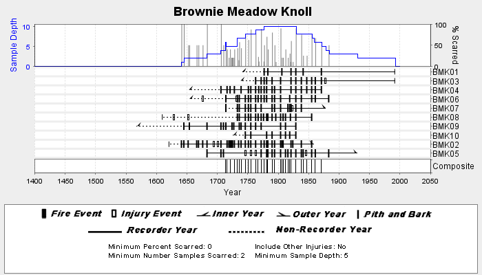
NOAA/WDS Paleoclimatology - Swetnam fire data from Brownie Meadow Knoll - IMPD USBMK001
National Oceanic and Atmospheric Administration, Department of Commerce —
This archived Paleoclimatology Study is available from the NOAA National Centers for Environmental Information (NCEI), under the World Data Service (WDS) for... -
Federal
Loop Current Observations in the Eastern Gulf of Mexico - SAIC Mooring Data (Currents)
National Oceanic and Atmospheric Administration, Department of Commerce —
Phsyical Oceanographic Circulation Study -
Federal
STARDUST DUST COLLECTOR GEOMETRY V1.0
National Aeronautics and Space Administration —
Data set describing the geometry and orientations of the spacecraft and the collector plate during the two interstellar dust collection phases and the Wild 2 encounter.

Official websites use .gov
A
.gov website belongs to an official government
organization in the United States.
Secure .gov websites use HTTPS
A
lock (
) or https:// means you’ve safely connected to
the .gov website. Share sensitive information only on official,
secure websites.