

1,560 datasets found
-
Federal
Regeneration trends along climate gradients in Taxodium distichum forest of the southeastern United States, 2007-2019
Department of the Interior —
Data provided are the volumes of cypress cones, collected in the North American Baldcypress Swamp Network along the Mississippi River Alluvial Valley (southern... -
Federal
The LakeCat Dataset: Accumulated Attributes for NHDPlusV2 (Version 2.1) Catchments for the Conterminous United States: Wildfire Burn Percent 1984-2018 (MTBS)
U.S. Environmental Protection Agency —
This dataset represents mean percent are burned from wildfires within individual local and accumulated upstream catchments for NHDPlusV2 Waterbodies for each year for... -
Federal
Quality assurance data to evaluate the vertical accuracy of the bathymetric data for Beaver Lake near Rogers, Arkansas, 2018
Department of the Interior —
Beaver Lake was constructed in 1966 on the White River in the northwest corner of Arkansas for flood control, hydroelectric power, public water supply, and... -
Federal
Regional Hydraulic Geometry Characteristics of Stream Channels in the Ouachita Mountains of Arkansas
Department of the Interior —
Seventeen streamflow-gaging stations, operated by the U.S. Geological Survey and distributed across the Ouachita Mountains of Arkansas and Oklahoma were selected for... -
Federal
2020 Cartographic Boundary File (KML), Current County Subdivision for Arkansas, 1:500,000
U.S. Census Bureau, Department of Commerce —
The 2020 cartographic boundary KMLs are simplified representations of selected geographic areas from the U.S. Census Bureau's Master Address File / Topologically... -
Federal
The LakeCat Dataset: Accumulated Attributes for NHDPlusV2 (Version 2.1) Catchments for the Conterminous United States: National Atmospheric Deposition Program National Trends Network - Nitrogen Deposition
U.S. Environmental Protection Agency —
This dataset represents deposition estimates of nutrients within individual local and accumulated upstream catchments for NHDPlusV2 Waterbodies based on the National... -
Federal
EnviroAtlas - Sheep Operations by County
U.S. Environmental Protection Agency —
This EnviroAtlas dataset summarizes by county the number of farm operations with sheep and the number of heads they manage. The data come from the Census of... -
Federal
Terrestrial Light Detection and Ranging Topographic Survey Data for Two Recreation Areas Near Blue Mountain Lake and Nimrod Lake, Arkansas, March 2020
Department of the Interior —
The U.S. Geological Survey collected topographic data in cooperation with the U.S. Army Corps of Engineers to assist in the management of two recreation areas at Blue... -
Federal
BCC Monthly Future Prescribed Burn Windows for the Southeast United States 2010-2099 RCP 4.5
Department of the Interior —
Prescribed burning is a critical tool for managing wildfire risks and meeting ecological objectives, but its safe and effective application requires that specific... -
Federal
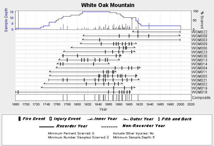
NOAA/WDS Paleoclimatology - Stambaugh fire data from White Oak Mountain - IMPD USWOM001
National Oceanic and Atmospheric Administration, Department of Commerce —
This archived Paleoclimatology Study is available from the NOAA National Centers for Environmental Information (NCEI), under the World Data Service (WDS) for... -
Federal
TIGER/Line Shapefile, 2022, State, Arkansas, Topological Faces-Area Landmark Relationship File
U.S. Census Bureau, Department of Commerce —
The TIGER/Line shapefiles and related database files (.dbf) are an extract of selected geographic and cartographic information from the U.S. Census Bureau's Master... -
Federal
Audiomagnetotelluric data, Buffalo River watershed, Arkansas, 2017; Station AMT170
Department of the Interior —
This dataset includes audio-magnetotelluric (AMT) sounding data collected in August 2017 in the Buffalo River watershed of northern Arkansas by the U.S. Geological... -
Federal
Magnetotelluric data from Missouri, Arkansas, Tennessee, Illinois, and Kentucky, 2016-2019, station sfm054
Department of the Interior —
This dataset consists of 127 wideband and 21 long-period magnetotelluric (MT) stations collected from 2016-2019 across parts of Missouri, Arkansas, Tennessee,... -
Federal
TIGER/Line Shapefile, 2022, State, Arkansas, AR, State Legislative District (SLD) Lower Chamber
U.S. Census Bureau, Department of Commerce —
The TIGER/Line shapefiles and related database files (.dbf) are an extract of selected geographic and cartographic information from the U.S. Census Bureau's Master... -
Federal
Magnetotelluric data from Missouri, Arkansas, Tennessee, Illinois, and Kentucky, 2016-2019, station mrv009
Department of the Interior —
This dataset consists of 127 wideband and 21 long-period magnetotelluric (MT) stations collected from 2016-2019 across parts of Missouri, Arkansas, Tennessee,... -
Federal
Magnetotelluric data from Missouri, Arkansas, Tennessee, Illinois, and Kentucky, 2016-2019, station rfr106
Department of the Interior —
This dataset consists of 127 wideband and 21 long-period magnetotelluric (MT) stations collected from 2016-2019 across parts of Missouri, Arkansas, Tennessee,... -
Federal
TIGER/Line Shapefile, 2023, County, Arkansas County, AR, All Lines
U.S. Census Bureau, Department of Commerce —
The TIGER/Line shapefiles and related database files (.dbf) are an extract of selected geographic and cartographic information from the U.S. Census Bureau's Master... -
State
1994 Natural Resource Inventory (polygon)
State of Arkansas —
Data available online through the Arkansas Spatial Data Infrastructure (http://gis.arkansas.gov). NRI Mapping Polygon boundaries for the conterminous United States. -
Federal
TIGER/Line Shapefile, 2021, County, Lonoke County, AR, All Roads
U.S. Census Bureau, Department of Commerce —
The TIGER/Line shapefiles and related database files (.dbf) are an extract of selected geographic and cartographic information from the U.S. Census Bureau's Master... -
Federal
The LakeCat Dataset: Accumulated Attributes for NHDPlusV2 (Version 2.1) Catchments for the Conterminous United States: Mine Density: Active Mines and Mineral Plants in the US
U.S. Environmental Protection Agency —
This dataset represents mine density within individual local and accumulated upstream catchments for NHDPlusV2 Waterbodies based on mine plants and operations...
1,560 datasets found