
-
Federal
Sentinel-3A OLCI Inland Waters (ILW) Data, version 4
National Aeronautics and Space Administration —
The Inland Waters dataset (ILW) provides data for lakes and other water bodies across the contiguous United States (CONUS) and Alaska. ILW significantly reduces the... -
Federal
SnowEx20 Grand Mesa Autumn 2019 Snow Pits V001
National Aeronautics and Space Administration —
This data set contains snow pit measurements obtained as part of the SnowEx 2020 campaign at the Grand Mesa, Colorado, USA site in Autumn 2019. 21 locations were... -
Federal
Height Above River Elevations for the Lower 10 Kilometers of the Snow River Flood Plain Near Seward, Alaska
Department of the Interior —
A height-above-river raster produced from 2008 lidar bare-earth elevations for the lower 10 kilometers of the Snow River flood plain is used as part of a geomorphic... -
Federal
Eklutna River at Glenn Highway Bridge, Alaska Cross-Section Survey, 2016 and 2017
Department of the Interior —
This dataset consists of survey data, plots, photos, and a photo index from a cross section survey of the Eklutna River at the Glenn Highway bridge in Alaska. The... -
Federal
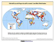
Global Multihazard Proportional Economic Loss Risk Deciles
National Aeronautics and Space Administration —
The Global Multihazard Proportional Economic Loss Risks is a 2.5 minute grid of a multihazard-based economic loss risk as a proportion of the economic productivity of... -
Federal
Coho Salmon (Oncorhynchus kisutch) Genetic Data, Glacier Bay National Park, Alaska (1994-1999)
Department of the Interior —
These are genetic data collected from over 700 individual coho salmon (Oncorhynchus kisutch) from 17 streams and rivers within Glacier Bay Alaska and 2 rivers outside... -
Federal
Global Multihazard Total Economic Loss Risk Deciles
National Aeronautics and Space Administration —
The Global Multihazard Total Economic Loss Risk Deciles is a 2.5 minute grid of global multihazard total economic loss risks. First, for each of the considered... -
Federal
Remotely sensed snow status analyzed for the paper titled "Multi-year data from satellite- and ground-based sensors show details and scale matter in assessing climate’s effects on wetland surface water, amphibians, and landscape conditions"
Department of the Interior —
This comma-delimited dataset provides values for the remotely sensed status of snow on/off analyzed for field study sites described in the paper, "Multi-year data... -
Federal
SENTINEL-1B_DUAL_POL_GRD_MEDIUM_RES
National Aeronautics and Space Administration —
Sentinel-1B Dual-pol ground projected medium resolution images -
Federal
Timeseries of Arctic-Boreal Lake Area Derived from CubeSat Imagery, 2017
National Aeronautics and Space Administration —
This dataset provides near-daily lake area timeseries for 85,358 lakes across four study areas in Northern Canada and Alaska, USA, between May 1 and October 1, 2017.... -
Federal
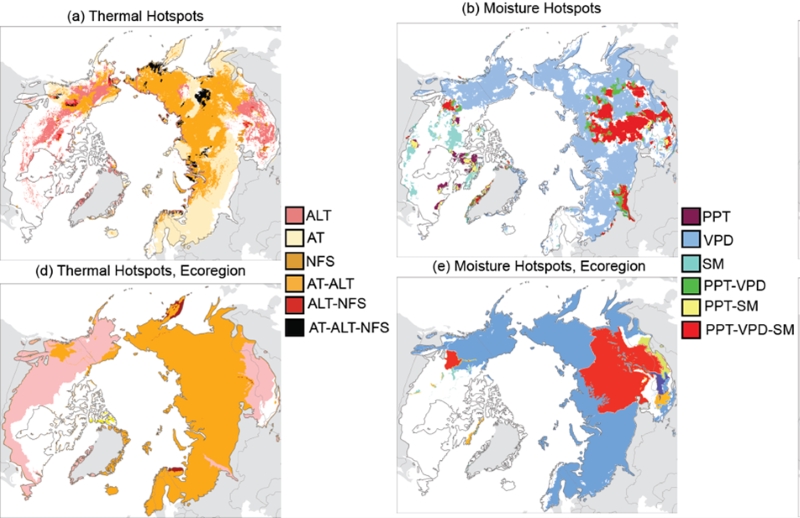
Trends of Thermal, Wetness, and Vegetative Change in the Circumpolar Arctic
National Aeronautics and Space Administration —
This dataset provides estimates of trends in temperature, moisture, and vegetation changes over the circumpolar Arctic. Time series trends were measured by the Theil-... -
Federal
Global Landslide Proportional Economic Loss Risk Deciles
National Aeronautics and Space Administration —
The Global Landslide Proportional Economic Loss Risk Deciles is a 2.5 minute grid of landslide hazard economic loss as proportions of Gross Domestic Product (GDP) per... -
Federal
Aerial Photographs (from AMES Pilot Land Data System); USGS EDC, Sioux Falls
National Aeronautics and Space Administration —
The aerial photography inventoried by the Pilot Land Data System (PLDS) at NASA AMES Research Center has been transferred to the USGS EROS Data Center. The photos... -
Federal
GLAS/ICESat L2 Global Antarctic and Greenland Ice Sheet Altimetry Data (HDF5) V034
National Aeronautics and Space Administration —
GLAH06 is used in conjunction with GLAH05 to create the Level-2 altimetry products. Level-2 altimetry data provide surface elevations for ice sheets (GLAH12), sea ice... -
Federal
SENTINEL-1A_SINGLE_POL_METADATA_GRD_HIGH_RES
National Aeronautics and Space Administration —
Sentinel-1A Single-pol ground projected high and full resolution metadata -
Federal
MEaSUREs Greenland Surface Melt Daily 25km EASE-Grid 2.0 V001
National Aeronautics and Space Administration —
This data set, part of the NASA Making Earth System Data Records for Use in Research Environments (MEaSUREs) program, offers users a 25 km daily record of... -
Federal
SENTINEL-1A_DUAL_POL_GRD_FULL_RES
National Aeronautics and Space Administration —
Sentinel-1A Dual-pol ground range detected full resolution images -
Federal
High Mountain Asia LIS Model Terrestrial Hydrological Parameters V001
National Aeronautics and Space Administration —
The data provided in this data set are simulated using the Noah-Multiparameterization Land Surface Model (Noah-MP LSM) Version 3.6 within the NASA Land Information... -
Federal
AMSR-E/Aqua Monthly L3 Global Snow Water Equivalent EASE-Grids V002
National Aeronautics and Space Administration —
These Level-3 Snow Water Equivalent (SWE) data sets contain SWE data and quality assurance flags mapped to Northern and Southern Hemisphere 25 km Equal-Area Scalable...

Official websites use .gov
A
.gov website belongs to an official government
organization in the United States.
Secure .gov websites use HTTPS
A
lock (
) or https:// means you’ve safely connected to
the .gov website. Share sensitive information only on official,
secure websites.