
-
Federal
TIGER/Line Shapefile, 2021, County, Dorchester County, SC, All Roads
U.S. Census Bureau, Department of Commerce —
The TIGER/Line shapefiles and related database files (.dbf) are an extract of selected geographic and cartographic information from the U.S. Census Bureau's Master... -
Federal
Bridging the Gap between Quadrats and Satellites: Assessing Utility of Drone-based Imagery to Enhance Emergent Vegetation Biomonitoring - NERRS/NSC(NERRS Science Collaborative)
National Oceanic and Atmospheric Administration, Department of Commerce —
Monitoring plays a central role in detecting change in coastal ecosystems. The National Estuarine Research Reserve System (NERRS) invests heavily in assessing changes... -
Federal
Digital Shoreline Analysis System version 4.3 Transects with Long-Term Linear Regression Rate Calculations for South Carolina (SC)
Department of the Interior —
Sandy ocean beaches are a popular recreational destination, often surrounded by communities containing valuable real estate. Development is on the rise despite the... -
Federal
TIGER/Line Shapefile, 2022, State, South Carolina, SC, Census Tract
U.S. Census Bureau, Department of Commerce —
The TIGER/Line shapefiles and related database files (.dbf) are an extract of selected geographic and cartographic information from the U.S. Census Bureau's Master... -
Federal
TIGER/Line Shapefile, 2021, State, South Carolina, County Subdivisions
U.S. Census Bureau, Department of Commerce —
The TIGER/Line shapefiles and related database files (.dbf) are an extract of selected geographic and cartographic information from the U.S. Census Bureau's Master... -
Federal
2022 Cartographic Boundary File (SHP), Current Unified School District for South Carolina, 1:500,000
U.S. Census Bureau, Department of Commerce —
The 2022 cartographic boundary shapefiles are simplified representations of selected geographic areas from the U.S. Census Bureau's Master Address File /... -
Federal
TIGER/Line Shapefile, Current, State, South Carolina, State Legislative District (SLD) Lower Chamber
U.S. Census Bureau, Department of Commerce —
This resource is a member of a series. The TIGER/Line shapefiles and related database files (.dbf) are an extract of selected geographic and cartographic information... -
Federal
TIGER/Line Shapefile, 2020, State, South Carolina, Voting Districts
U.S. Census Bureau, Department of Commerce —
The TIGER/Line shapefiles and related database files (.dbf) are an extract of selected geographic and cartographic information from the U.S. Census Bureau's Master... -
Federal
2 Observations: Deep learning approaches for improving prediction of daily stream temperature in data-scarce, unmonitored, and dammed basins
Department of the Interior —
This data release component contains mean daily stream water temperature observations, retrieved from the USGS National Water Information System (NWIS) and used to... -
Federal
TIGER/Line Shapefile, 2024, State, South Carolina, 2020 Census Blocks with Suffixes
U.S. Census Bureau, Department of Commerce —
The TIGER/Line shapefiles and related database files (.dbf) are an extract of selected geographic and cartographic information from the U.S. Census Bureau's Master... -
Federal
2020 Cartographic Boundary File (SHP), 2020 Public Use Microdata Areas for South Carolina, 1:500,000
U.S. Census Bureau, Department of Commerce —
The 2020 cartographic boundary shapefiles are simplified representations of selected geographic areas from the U.S. Census Bureau's Master Address File /... -
Federal
TIGER/Line Shapefile, 2021, County, Saluda County, SC, All Roads
U.S. Census Bureau, Department of Commerce —
The TIGER/Line shapefiles and related database files (.dbf) are an extract of selected geographic and cartographic information from the U.S. Census Bureau's Master... -
Federal
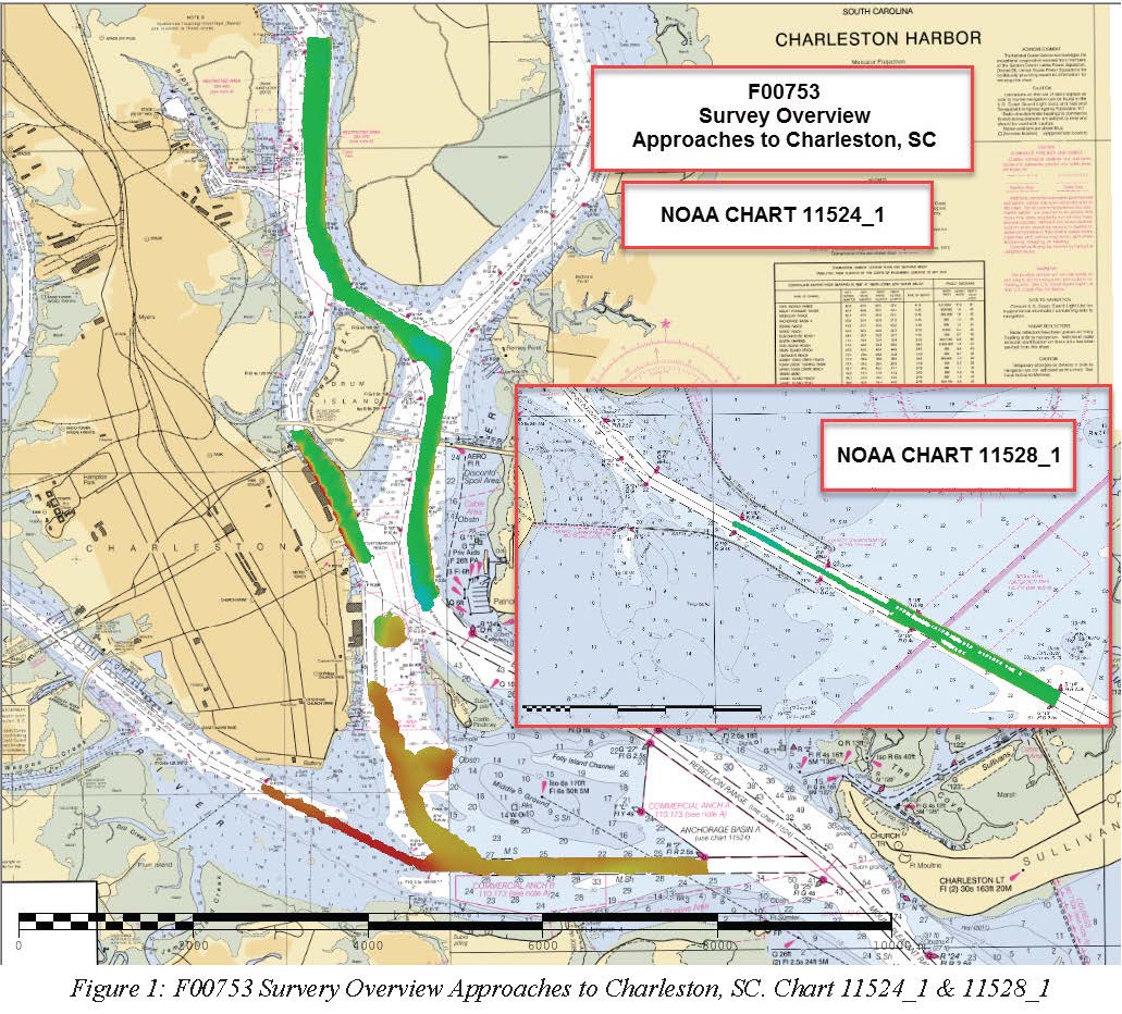
F00753: NOS Hydrographic Survey , 2018-10-23
National Oceanic and Atmospheric Administration, Department of Commerce —
The National Oceanic and Atmospheric Administration (NOAA) has the statutory mandate to collect hydrographic data in support of nautical chart compilation for safe... -
Federal
TIGER/Line Shapefile, 2021, County, Darlington County, SC, All Roads
U.S. Census Bureau, Department of Commerce —
The TIGER/Line shapefiles and related database files (.dbf) are an extract of selected geographic and cartographic information from the U.S. Census Bureau's Master... -
Federal
TIGER/Line Shapefile, 2022, State, South Carolina, Topological Faces-Area Landmark Relationship File
U.S. Census Bureau, Department of Commerce —
The TIGER/Line shapefiles and related database files (.dbf) are an extract of selected geographic and cartographic information from the U.S. Census Bureau's Master... -
Federal
Understanding South Carolina's "Swash Cycle" - NERRS/NSC(NERRS Science Collaborative)
National Oceanic and Atmospheric Administration, Department of Commerce —
Myrtle Beach is an economic pearl in South Carolinaâs grand strand, a sixty-mile stretch of beaches and resort communities that support a multi-billion dollar... -
Federal
Connecting the Dots between Data and Atlantic Fisheries Management - NERRS/NSC(NERRS Science Collaborative)
National Oceanic and Atmospheric Administration, Department of Commerce —
Changes in coastal conditions, including those associated with a shifting climate, can impact the spawning, growth, and ultimately, survival of commercially and... -
Federal
TIGER/Line Shapefile, 2021, County, Chester County, SC, All Roads
U.S. Census Bureau, Department of Commerce —
The TIGER/Line shapefiles and related database files (.dbf) are an extract of selected geographic and cartographic information from the U.S. Census Bureau's Master... -
Federal
TIGER/Line Shapefile, 2021, County, Allendale County, SC, All Roads
U.S. Census Bureau, Department of Commerce —
The TIGER/Line shapefiles and related database files (.dbf) are an extract of selected geographic and cartographic information from the U.S. Census Bureau's Master... -
Federal
TIGER/Line Shapefile, 2021, State, South Carolina, Elementary School Districts
U.S. Census Bureau, Department of Commerce —
The TIGER/Line shapefiles and related database files (.dbf) are an extract of selected geographic and cartographic information from the U.S. Census Bureau's Master...

Official websites use .gov
A
.gov website belongs to an official government
organization in the United States.
Secure .gov websites use HTTPS
A
lock (
) or https:// means you’ve safely connected to
the .gov website. Share sensitive information only on official,
secure websites.