
-
University
Colfax County Blocks, Age by 5-Year Age Groups for Females (2010)
Earth Data Analysis Center, University of New Mexico —
The once-a-decade decennial census was conducted in April 2010 by the U.S. Census Bureau. This count of every resident in the United States was mandated by Article I,... -
Federal
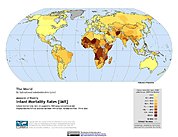
Poverty Mapping Project: Global Subnational Infant Mortality Rates
National Aeronautics and Space Administration —
The Poverty Mapping Project: Global Subnational Infant Mortality Rates data set consists of estimates of infant mortality rates for the year 2000. The infant... -
County
Pittsburgh American Community Survey Data 2015 - Household Types
Allegheny County / City of Pittsburgh / Western PA Regional Data Center —
The data on relationship to householder were derived from answers to Question 2 in the 2015 American Community Survey (ACS), which was asked of all people in housing... -
University
Grant County Block Groups, Race and Hispanic Ethnicity (2010)
Earth Data Analysis Center, University of New Mexico —
The once-a-decade decennial census was conducted in April 2010 by the U.S. Census Bureau. This count of every resident in the United States was mandated by Article I,... -
Federal
Digital data sets describing population density in the conterminous US
Department of the Interior —
Grid of population density in the conterminous United States at a resolution of one kilometer. The grid was converted from an ASCII file obtained from the Consortium... -
State
Iowa Population by Poverty Status (Past 12 Months), Sex and Educational Attainment (ACS 5-Year Estimates)
State of Iowa —
This dataset contains Iowa population estimates by poverty status (past 12 months), sex and educational attainment for State of Iowa, individual Iowa counties, Iowa... -
Federal
Archive of Census Related Products (ACRP): 1990 Census Block Statistics
National Aeronautics and Space Administration —
The 1990 Census Block Statistics portion of the Archive of Census Related Products (ACRP) contains population and housing data from the U.S. Census Bureau's 1990... -
University
Dona Ana County Blocks, Total Population (2010)
Earth Data Analysis Center, University of New Mexico —
The once-a-decade decennial census was conducted in April 2010 by the U.S. Census Bureau. This count of every resident in the United States was mandated by Article I,... -
University
Harding County Blocks, Age by 5-Year Age Groups for Both Sexes Combined (2010)
Earth Data Analysis Center, University of New Mexico —
The once-a-decade decennial census was conducted in April 2010 by the U.S. Census Bureau. This count of every resident in the United States was mandated by Article I,... -
County
Census Block Groups 2010
Wake County —
Wake County Census Block Groups 2010 U.S. Census Bureau: Block group population should range from 1,200 to 3,000. Census Block Groups are the smallest geographic... -
Federal
Archive of Census Related Products (ACRP): 1990 Public Use Microdata Sample Areas (PUMA) Boundary Files
National Aeronautics and Space Administration —
The 1990 Public Use Microdata Sample Areas (PUMA) Boundary Files portion of the Archive of Census Related Products (ACRP) consists of 5% sample (apuma) and 1% sample... -
University
Rio Arriba County Block Groups, Race and Hispanic Ethnicity (2010)
Earth Data Analysis Center, University of New Mexico —
The once-a-decade decennial census was conducted in April 2010 by the U.S. Census Bureau. This count of every resident in the United States was mandated by Article I,... -
Federal
2000 population density by block group for the conterminous United States
Department of the Interior —
This data set represents 2000 population density by block group as a 100-m grid using data from the 2000 Census of Population and Housing. The demographic data is... -
Federal
Glacier Bay, Alaska murrelet survey abundance estimates (KM_K)
Department of the Interior —
Tabular data in CSV form of marbled and Kittlitz's murrelet population status and trend estimates made during the SEAN monitoring program. A zip package containing... -
State
Maryland Counties Socioeconomic Characteristics (ACS 5-yr Estimates 2022)
State of Maryland —
Data for population, gender, race, labor force, educational attainment, income, poverty, households and housing units from the American Community Survey 5-yr... -
City
ACS 14 5YR B01001
City of Ferndale, Michigan —
The Kresge early childhood interactive map contains data relating to early childhood and education. It is meant to help stakeholders better understand the early... -
Federal
National Aggregates of Geospatial Data Collection: Population, Landscape, And Climate Estimates, Version 4 (PLACE IV)
National Aeronautics and Space Administration —
The National Aggregates of Geospatial Data Collection: Population, Landscape, And Climate Estimates, Version 4 (PLACE IV) provides measures of population (head... -
City
Race and Ethnicity - ACS 2018-2022 - Tempe Tracts
City of Tempe —
This layer shows population broken down by race and Hispanic origin. Data is from US Census American Community Survey (ACS) 5-year estimates.This layer is symbolized... -
University
Mora County Blocks, Age by 5-Year Age Groups for Both Sexes Combined (2010)
Earth Data Analysis Center, University of New Mexico —
The once-a-decade decennial census was conducted in April 2010 by the U.S. Census Bureau. This count of every resident in the United States was mandated by Article I,...

Official websites use .gov
A
.gov website belongs to an official government
organization in the United States.
Secure .gov websites use HTTPS
A
lock (
) or https:// means you’ve safely connected to
the .gov website. Share sensitive information only on official,
secure websites.