
-
Federal
2023 Cartographic Boundary File (KML), 118th Congressional Districts for Louisiana, 1:500,000
U.S. Census Bureau, Department of Commerce —
The 2023 cartographic boundary KMLs are simplified representations of selected geographic areas from the U.S. Census Bureau's Master Address File / Topologically... -
Federal
TIGER/Line Shapefile, Current, State, Louisiana, 119th Congressional District
U.S. Census Bureau, Department of Commerce —
This resource is a member of a series. The TIGER/Line shapefiles and related database files (.dbf) are an extract of selected geographic and cartographic information... -
Federal
2020 Cartographic Boundary File (KML), Current State Legislative District-Upper Chamber for Louisiana, 1:500,000
U.S. Census Bureau, Department of Commerce —
The 2020 cartographic boundary KMLs are simplified representations of selected geographic areas from the U.S. Census Bureau's Master Address File / Topologically... -
Federal
H12791: NOS Hydrographic Survey , 2016-03-26
National Oceanic and Atmospheric Administration, Department of Commerce —
The National Oceanic and Atmospheric Administration (NOAA) has the statutory mandate to collect hydrographic data in support of nautical chart compilation for safe... -
Federal
Gulf Coast Estimated Thickness of the Upper Miocene Sequence
Department of the Interior —
The thickness contours were created using biostratigraphic data in the Paleo-Data, Inc., Tenroc Regional Geologic Database. The depths of the microfossil locations... -
Federal
National Assessment of Oil and Gas Quarter-Mile Cells - Cotton Valley Group and Travis Peak-Hosston Formations, Western Gulf and East Texas Basin and Louisiana-Mississippi Salt Basins Provinces (047, 048 and 049)
Department of the Interior —
Cell maps for each oil and gas assessment unit were created by the USGS as a method for illustrating the degree of exploration, type of production, and distribution... -
Federal
2023 Cartographic Boundary File (KML), County Subdivision for Louisiana, 1:500,000
U.S. Census Bureau, Department of Commerce —
The 2023 cartographic boundary KMLs are simplified representations of selected geographic areas from the U.S. Census Bureau's Master Address File / Topologically... -
Federal
2023 Cartographic Boundary File (SHP), State Legislative District (SLD) Lower Chamber for Louisiana, 1:500,000
U.S. Census Bureau, Department of Commerce —
The 2023 cartographic boundary shapefiles are simplified representations of selected geographic areas from the U.S. Census Bureau's Master Address File /... -
Federal
Faults in the Gulf Coast [gcfaultsg]
Department of the Interior —
These mapped faults are modified from Plate 2, Principal structural features, Gulf of Mexico Basin (compiled by T.E. Ewing and R.F. Lopez) in Volume J, The Geology of... -
Federal
2020 Cartographic Boundary File (SHP), Current State Legislative District-Upper Chamber for Louisiana, 1:500,000
U.S. Census Bureau, Department of Commerce —
The 2020 cartographic boundary shapefiles are simplified representations of selected geographic areas from the U.S. Census Bureau's Master Address File /... -
Federal
Structure Contour of the Top of the Travis Peak-Hosston Formations, Western Gulf and East Texas Basin and Louisiana-Mississippi Salt Basins Provinces (047, 048 and 049)
Department of the Interior —
This map shows the structural configuration of the top of the Travis Peak or Hosston Formations in feet below sea level. The map was produced by calculating the... -
Federal
2022 Cartographic Boundary File (SHP), Current State Legislative District-Lower Chamber for Louisiana, 1:500,000
U.S. Census Bureau, Department of Commerce —
The 2022 cartographic boundary shapefiles are simplified representations of selected geographic areas from the U.S. Census Bureau's Master Address File /... -
Federal
2020 Cartographic Boundary File (SHP), Current Unified School District for Louisiana, 1:500,000
U.S. Census Bureau, Department of Commerce —
The 2020 cartographic boundary shapefiles are simplified representations of selected geographic areas from the U.S. Census Bureau's Master Address File /... -
Federal
2023 Cartographic Boundary File (KML), State Legislative District (SLD) Lower Chamber for Louisiana, 1:500,000
U.S. Census Bureau, Department of Commerce —
The 2023 cartographic boundary KMLs are simplified representations of selected geographic areas from the U.S. Census Bureau's Master Address File / Topologically... -
Federal
TIGER/Line Shapefile, 2023, State, Louisiana, LA, State Legislative District (SLD) Upper Chamber
U.S. Census Bureau, Department of Commerce —
The TIGER/Line shapefiles and related database files (.dbf) are an extract of selected geographic and cartographic information from the U.S. Census Bureau's Master... -
Federal
TIGER/Line Shapefile, 2021, County, St. Landry Parish, LA, All Roads
U.S. Census Bureau, Department of Commerce —
The TIGER/Line shapefiles and related database files (.dbf) are an extract of selected geographic and cartographic information from the U.S. Census Bureau's Master... -
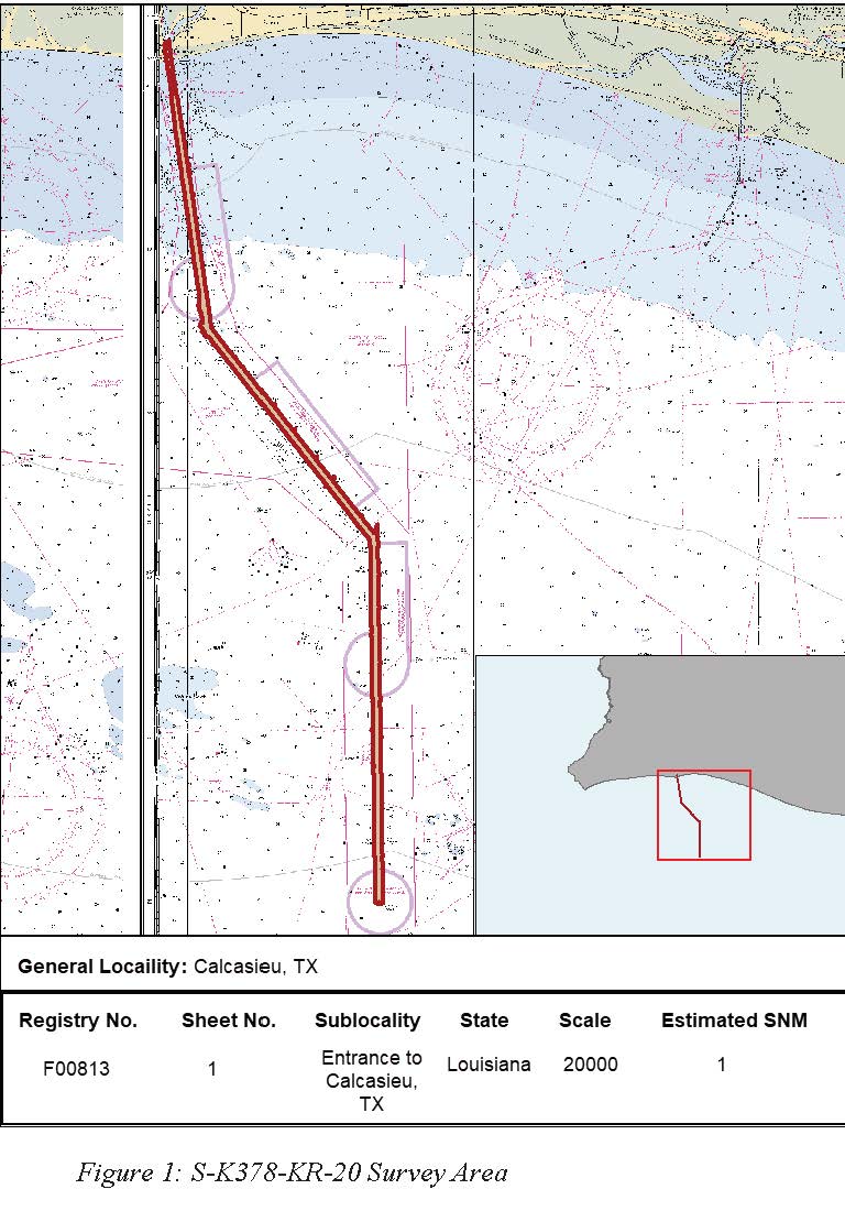
Federal
F00813: NOS Hydrographic Survey , 2020-09-27
National Oceanic and Atmospheric Administration, Department of Commerce —
The National Oceanic and Atmospheric Administration (NOAA) has the statutory mandate to collect hydrographic data in support of nautical chart compilation for safe... -
Federal
TIGER/Line Shapefile, 2021, County, Iberia Parish, LA, All Roads
U.S. Census Bureau, Department of Commerce —
The TIGER/Line shapefiles and related database files (.dbf) are an extract of selected geographic and cartographic information from the U.S. Census Bureau's Master... -
Federal
TIGER/Line Shapefile, 2021, County, Acadia Parish, LA, All Roads
U.S. Census Bureau, Department of Commerce —
The TIGER/Line shapefiles and related database files (.dbf) are an extract of selected geographic and cartographic information from the U.S. Census Bureau's Master... -
Federal
2020 Cartographic Boundary File (KML), 2020 Public Use Microdata Areas for Louisiana, 1:500,000
U.S. Census Bureau, Department of Commerce —
The 2020 cartographic boundary KMLs are simplified representations of selected geographic areas from the U.S. Census Bureau's Master Address File / Topologically...

Official websites use .gov
A
.gov website belongs to an official government
organization in the United States.
Secure .gov websites use HTTPS
A
lock (
) or https:// means you’ve safely connected to
the .gov website. Share sensitive information only on official,
secure websites.