
-
Federal
Gateway to Astronaut Photography of Earth
National Aeronautics and Space Administration —
Planetary nomenclature, like terrestrial nomenclature, is used to uniquely identify a feature on the surface of a planet or satellite so that the feature can be... -
Federal
Gazetteer of Planetary Nomenclature
National Aeronautics and Space Administration —
Planetary nomenclature, like terrestrial nomenclature, is used to uniquely identify a feature on the surface of a planet or satellite so that the feature can be... -
Federal
Gazetteer of Planetary Nomenclature
National Aeronautics and Space Administration —
Planetary nomenclature, like terrestrial nomenclature, is used to uniquely identify a feature on the surface of a planet or satellite so that the feature can be... -
Federal
2005 Hawaii IfSAR Digital Terrain Model (DTM)
National Oceanic and Atmospheric Administration, Department of Commerce —
Intermap DEMs populate its data store. The DEM products are generated using Intermap's STAR technology (Interferometric Synthetic Aperture Radar). The system is... -
Federal
Gazetteer of Planetary Nomenclature
National Aeronautics and Space Administration —
Planetary nomenclature, like terrestrial nomenclature, is used to uniquely identify a feature on the surface of a planet or satellite so that the feature can be... -
Federal
Positive openness rasters for the Greater Raleigh Area, North Carolina
Department of the Interior —
Rasters of positive openness and positive openness difference in the Greater Raleigh, NC Area based on 1-meter high-resolution lidar-derived digital elevation models... -
Federal
Gazetteer of Planetary Nomenclature
National Aeronautics and Space Administration —
Planetary nomenclature, like terrestrial nomenclature, is used to uniquely identify a feature on the surface of a planet or satellite so that the feature can be... -
Federal
Unprocessed aerial imagery from 9 December 2015 coastal survey of Central California.
Department of the Interior —
This is a set of 1132 oblique aerial photogrammetric images and their derivatives, collected from Capitola to Pajaro Dunes with a fixed-lens digital camera from a... -
Federal
Gazetteer of Planetary Nomenclature
National Aeronautics and Space Administration —
Planetary nomenclature, like terrestrial nomenclature, is used to uniquely identify a feature on the surface of a planet or satellite so that the feature can be... -
Federal
Unprocessed aerial imagery from 26 September 2016 coastal survey of Central California.
Department of the Interior —
This is a set of 1569 oblique aerial photogrammetric images and their derivatives, collected from San Francisco to Ano Nuevo with a fixed-lens digital camera from a... -
Federal
Gazetteer of Planetary Nomenclature
National Aeronautics and Space Administration —
Planetary nomenclature, like terrestrial nomenclature, is used to uniquely identify a feature on the surface of a planet or satellite so that the feature can be... -
Federal
DisMOSH, Cost, MOSHShoreline: Distance to foraging areas for piping plovers (foraging shoreline, cost mask, and least-cost path distance): Fire Island, NY, 2010–2011
Department of the Interior —
Understanding how sea-level rise will affect coastal landforms and the species and habitats they support is critical for crafting approaches that balance the needs of... -
Federal
Flow Accumulation Raster for Maine StreamStats
Department of the Interior —
This dataset consists of flow accumulation rasters for each 4-digit Hydrologic Unit Code (HUC) area in Maine (0101, 0102, 0103, 0104, 0105, and 0106). Each raster... -
Federal
SAWSC PeakFQ input and output files for at-site flood-frequency statistics
Department of the Interior —
Reliable estimates of the magnitude and frequency of floods are an important part of the framework for hydraulic-structure design and flood-plain management in... -
Federal
Unprocessed aerial imagery from 17 March 2023 coastal survey of Central California.
Department of the Interior —
This is a set of 2077 oblique aerial photogrammetric images and their derivatives, collected from Monterey to Ragged Point with a fixed-lens digital camera from a... -
Federal
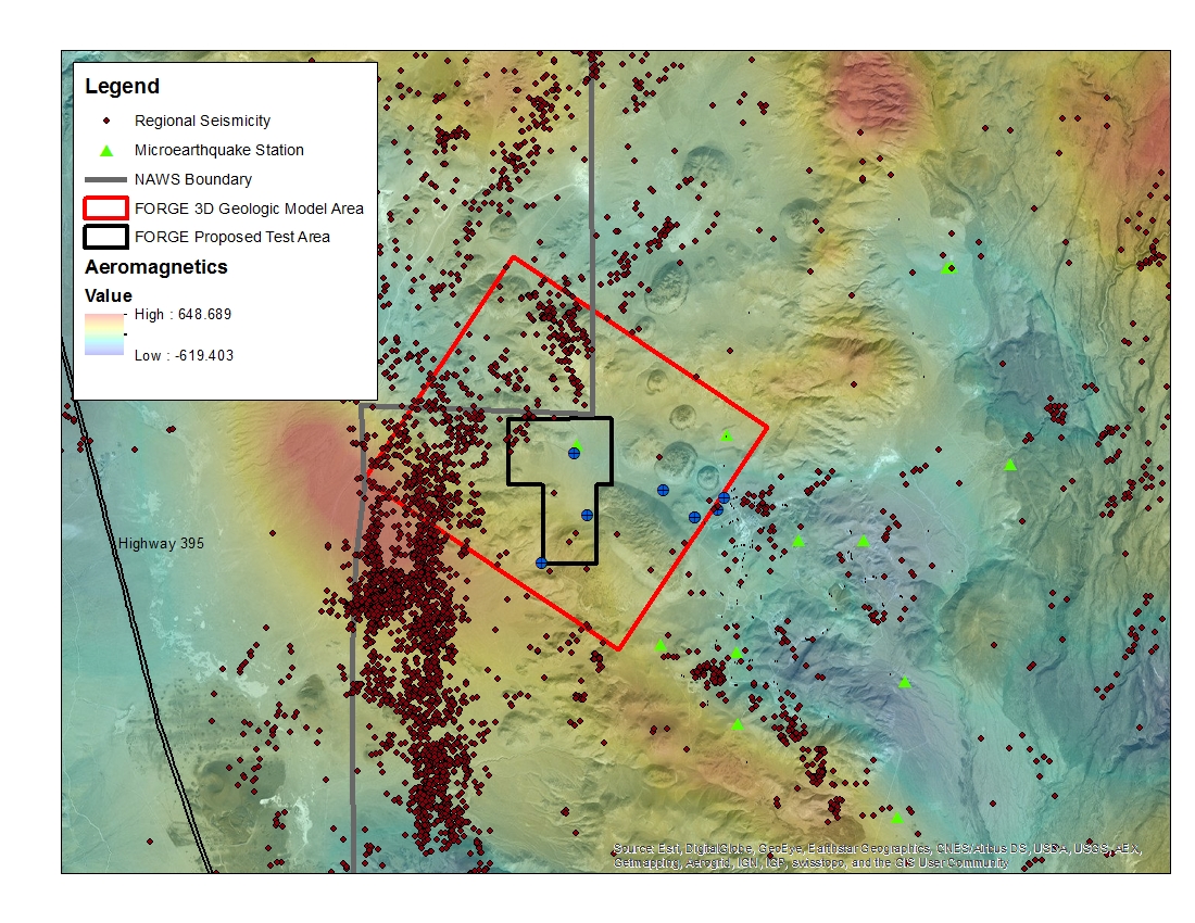
West Flank Coso, CA FORGE Test Area
Department of Energy —
A map with the Coso West Flank FORGE test area outlined, along with regional seismicity, the aeromagnetic data set and the area currently being utilized for the... -
Federal
Gazetteer of Planetary Nomenclature
National Aeronautics and Space Administration —
Planetary nomenclature, like terrestrial nomenclature, is used to uniquely identify a feature on the surface of a planet or satellite so that the feature can be... -
Federal
Unprocessed aerial imagery from 18 September 2020 coastal survey of Southern California.
Department of the Interior —
This is a set of 1968 oblique aerial photogrammetric images and their derivatives, collected from Santa Barbara Channel with a fixed-lens digital camera from a crewed... -
Federal
Gazetteer of Planetary Nomenclature
National Aeronautics and Space Administration —
Planetary nomenclature, like terrestrial nomenclature, is used to uniquely identify a feature on the surface of a planet or satellite so that the feature can be... -
Federal
Gateway to Astronaut Photography of Earth
National Aeronautics and Space Administration —
Planetary nomenclature, like terrestrial nomenclature, is used to uniquely identify a feature on the surface of a planet or satellite so that the feature can be...

Official websites use .gov
A
.gov website belongs to an official government
organization in the United States.
Secure .gov websites use HTTPS
A
lock (
) or https:// means you’ve safely connected to
the .gov website. Share sensitive information only on official,
secure websites.