
-
Federal
Quality Controlled Local Climatological Data (QCLCD) Publication
National Oceanic and Atmospheric Administration, Department of Commerce —
Quality Controlled Local Climatological Data (QCLCD) contains summaries from major airport weather stations that include a daily account of temperature extremes,... -
Federal
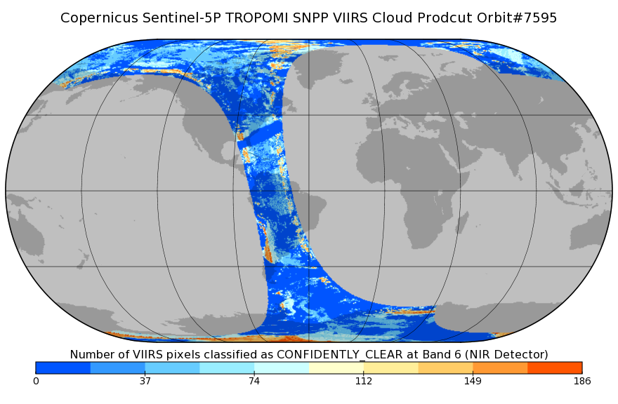
Sentinel-5P TROPOMI SNPP VIIRS cloud product band 6 (NIR detector) 1-Orbit L2 7km x 3.5km V1 (S5P_L2__NP_BD6) at GES DISC
National Aeronautics and Space Administration —
Starting from August 6th in 2019, Sentinel-5P TROPOMI along-track high spatial resolution (~5.5km at nadir) has been implemented. For data after August 6th of 2019,... -
Federal
Infrared Atmospheric Sounding Interferometer (IASI) Level 2 Cloud cleared Radiances (CCR)
National Oceanic and Atmospheric Administration, Department of Commerce —
The Infrared Atmospheric Sounding Interferometer is a Cross-nadir infrared sounder flown on the European MetOp satellite series. IASI measures atmospheric emission... -
Federal
TOVS GLA DAILY GRIDS from NOAA-12 V01 (TOVSADND) at GES DISC
National Aeronautics and Space Administration —
This dataset (TOVSADND) contains the TIROS Operational Vertical Sounder (TOVS) level 3 geophysical parameters derived using data from NOAA-12 and the physical... -
Federal
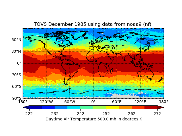
TOVS GLA MONTHLY GRIDS from NOAA-9 02 (TOVSAMNF) at GES DISC
National Aeronautics and Space Administration —
This dataset (TOVSAMNF) contains the TIROS Operational Vertical Sounder (TOVS) level 3 geophysical parameters derived using data from NOAA-9 and the physical... -
Federal
AMSR-E/AMSR2 Unified L3 Global Monthly Ascending/Descending .25x.25 deg Ocean Grids V001
National Aeronautics and Space Administration —
The AMSR-E/AMSR2 Unified L3 Global Monthly Ascending/Descending .25x.25 deg Ocean Grids data set is a gridded product that reports monthly estimates of water vapor,... -
Federal
CERES MODIS Cloud Retrievals in ISCCP-D2like Format Daytime Aqua FM4 Edition3A NGDA
National Aeronautics and Space Administration —
CER_ISCCP-D2like-Day_Aqua-FM4-MODIS_Edition3A is the Clouds and the Earth's Radiant Energy System (CERES) Moderate Resolution Imaging Spectroradiometer (MODIS) Cloud... -
Federal
TRMM Microwave Imager Hydrometeor Profile L2 1.5 hours V7 (TRMM_2A12) at GES DISC
National Aeronautics and Space Administration —
The new version of these data is in GPM-like format and can be found under the name GPM_2AGPROFTRMMTMI_CLIM. This dataset, 2A12, ”TMI Profiling”, generates surface... -
Federal
TES/Aura L2 Methanol Nadir V007
National Aeronautics and Space Administration —
TL2MTLN_7 is the Tropospheric Emission Spectrometer (TES)/Aura Level 2 Methanol Nadir Version 7 data product. TES was an instrument aboard NASA's Aura satellite and... -
Federal
TES/Aura L2 Methane Nadir V007
National Aeronautics and Space Administration —
TL2CH4N_7 is the Tropospheric Emission Spectrometer (TES)/Aura Level 2 Methane Nadir Version 7 data product. TES was an instrument aboard NASA's Aura satellite and... -
Federal
TOVS GLA DAILY GRIDS from NOAA-10 V01 (TOVSADNG) at GES DISC
National Aeronautics and Space Administration —
This dataset (TOVSADNG) contains the TIROS Operational Vertical Sounder (TOVS) level 3 geophysical parameters derived using data from NOAA-10 and the physical... -
Federal
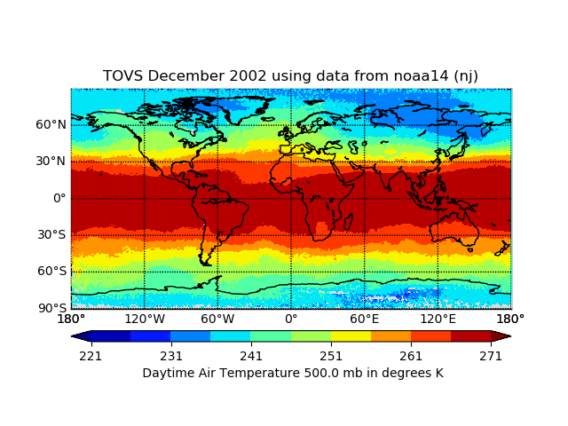
TOVS GLA MONTHLY GRIDS from NOAA-14 02 (TOVSAMNJ) at GES DISC
National Aeronautics and Space Administration —
This dataset (TOVSAMNJ) contains the TIROS Operational Vertical Sounder (TOVS) level 3 geophysical parameters derived using data from NOAA-14 and the physical... -
Federal
TES/Aura L2 Methane Nadir Special Observation V007
National Aeronautics and Space Administration —
TL2CH4NS_7 is the Tropospheric Emission Spectrometer (TES)/Aura Level 2 Methane Nadir Special Observation Version 7 data product. TES was an instrument aboard NASA's... -
Federal
Figure data for article "Acidity and the multiphase chemistry of atmospheric aqueous particles and clouds"
U.S. Environmental Protection Agency —
Noting here that data used to make figures in "Acidity and the multiphase chemistry of atmospheric aqueous particles and clouds" article can be found within the paper... -
Federal
AMSR-E/Aqua L2B Global Swath Ocean Products derived from Wentz Algorithm V002
National Aeronautics and Space Administration —
This daily Level-2B swath data set includes Sea Surface Temperature (SST), Near-Surface Wind Speed, Columnar Water Vapor, and Cloud liquid Water data arrays, and was... -
Federal
TOVS GLA DAILY GRIDS from TIROSN V01 (TOVSADTN) at GES DISC
National Aeronautics and Space Administration —
This dataset (TOVSADTN) contains the TIROS Operational Vertical Sounder (TOVS) level 3 geophysical parameters derived using data from TIROS-N and the physical... -
Federal
AERONET-OCEAN COLOR
National Aeronautics and Space Administration —
The Aerosol Robotic Network (AERONET), developed to sustain atmospheric studies at various scales with measurements from worldwide distributed autonomous sun-... -
Federal
Global Marine Surface Observations from Ocean Surface Vessels
National Oceanic and Atmospheric Administration, Department of Commerce —
The Primary source of data used to produce these files were from vessels of the following cooperatives: Cuba, Denmark, Finland, France, Germany (Federal Republic of... -
Federal
The Acidity of Atmospheric Particles and Clouds
U.S. Environmental Protection Agency —
Dataset contains supplementary information (model inputs and/or outputs and literature values) for Section 4.1 (idealized acidity calculations), Section 4.2 (box... -
Federal
SWOT Level 2 Radiometer Brightness Temperatures and Troposphere Interim Data Product, Version 2.0
National Aeronautics and Space Administration —
The SWOT Level 2 Radiometer Brightness Temperatures and Troposphere Interim Geophysical Data Record (IGDR) Version 1.0 dataset produced by the Surface Water and Ocean...

Official websites use .gov
A
.gov website belongs to an official government
organization in the United States.
Secure .gov websites use HTTPS
A
lock (
) or https:// means you’ve safely connected to
the .gov website. Share sensitive information only on official,
secure websites.