
-
Federal
Ground-Based Global Navigation Satellite System (GNSS) GLONASS real-time POD Clock Corrections (1-second sampling, 60-second files) from NASA CDDIS
National Aeronautics and Space Administration —
This product contains a high-rate time series of clock biases for healthy satellites in the GLONASS constellation that are accumulated every minute throughout the... -
Federal
Ground-Based Global Navigation Satellite System (GNSS) GPS real-time POD Orbits (60-second sampling, 60-second files) from NASA CDDIS
National Aeronautics and Space Administration —
This product contains a time series of position and velocity components for healthy satellites in the GPS constellation that are accumulated every minute throughout... -
Federal
TROPICS03 L2B Deep Multispectral INtensity (DMIN) of Tropical cyclones estimator Algorithm V1.0
National Aeronautics and Space Administration —
The "Time-Resolved Observations of Precipitation structure and storm Intensity with a Constellation of Smallsats" (TROPICS) mission has a goal of providing nearly... -
Federal
TROPESS Chemical Reanalysis SO2 Monthly 3-dimensional Product V1 (TRPSCRSO2M3D) at GES DISC
National Aeronautics and Space Administration —
The TROPESS Chemical Reanalysis SO2 Monthly 3-dimensional Product contains vertical concentrations of sulfur dioxide. The data are part of the Tropospheric Chemical... -
Federal
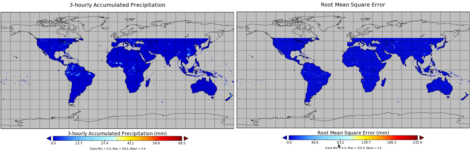
TMI/TRMM precipitation and uncertainty (TMPA) L3 3 hour 0.25 degree x 0.25 degree V001 (WC_MULTISEN_PREC_025) at GES DISC
National Aeronautics and Space Administration —
TMI/TRMM precipitation and uncertainty (TMPA) L3 3 hour 0.25 degree x 0.25 degree V001 provides estimates of accumulated precipitation from the Tropical Rainfall... -
Federal
Global Navigation Satellite System (GNSS) Rapid Clocks Products from NASA CDDIS
National Aeronautics and Space Administration —
Satellite and receiver clock products derived from analysis of Global Navigation Satellite System (GNSS) data. These products are the generated by analysis centers in... -
Federal
Global Navigation Satellite System (GNSS) Earth Rotation Parameters (ERP) products from NASA CDDIS
National Aeronautics and Space Administration —
Earth Rotation Parameters (ERPs) derived from analysis of Global Navigation Satellite System (GNSS) data. These products are the generated by analysis centers in... -
Federal
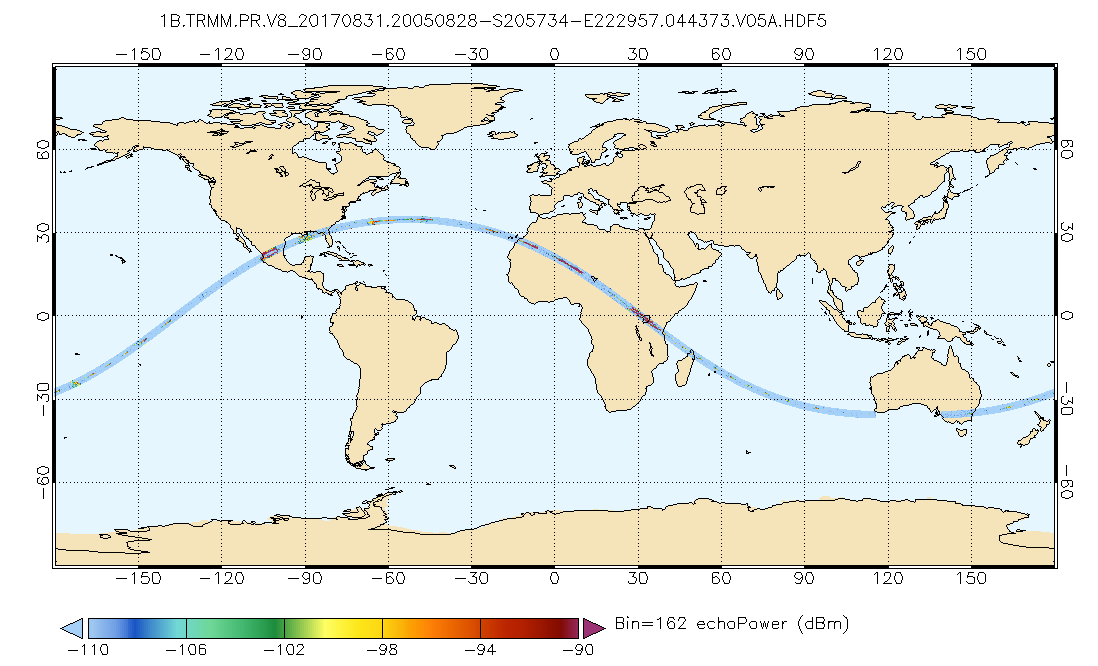
GPM PR on TRMM Echo Power L1B 1.5 hours 5 km V07 (GPM_1BPR) at GES DISC
National Aeronautics and Space Administration —
This is the new (GPM-formated) TRMM product. It replaces the old TRMM_1B21,1C21 Version 07 is the current version of the data set. Previous versions have been... -
Federal
Sentinel-6A MF Jason-CS L2 P4 Altimeter Low Resolution (LR) NTC Reduced Ocean Surface Topography (Unvalidated) F08
National Aeronautics and Space Administration —
Provides low resolution (LR) non-time critical (NTC; 60-day latency) measurements of sea surface height anomaly (SSHA), Significant Wave Height (SWH), and Wind Speed.... -
Federal
SENTINEL-1A_DUAL_POL_METADATA_GRD_HIGH_RES
National Aeronautics and Space Administration —
Sentinel-1A Dual-pol ground projected high and full resolution metadata -
Federal
San Diego Coastal Project
National Aeronautics and Space Administration —
Measurements near the Southern Californias coast made under the San Diego Coastal Project between 2004 and 2006. -
Federal
First ISCCP Regional Experiment (FIRE) Atlantic Stratocumulus Transition Experiment (ASTEX) Rawinsonde Level 1 Data
National Aeronautics and Space Administration —
The First ISCCP Regional Experiments (FIRE) have been designed to improve data products and cloud/radiation parameterizations used in general circulation models... -
Federal
First ISCCP Regional Experiment (FIRE) Arctic Cloud Experiment (ACE) CV580 Aircraft G-Meter Data
National Aeronautics and Space Administration —
This data set consists of light scattering measurements provided by the 4-channel nephelometer g-meter instrument flown onboard the University of Washington's CV580... -
Federal
ECOSTRESS Gridded Top of Atmosphere Calibrated Radiance Instantaneous L1C Global 70 m V002
National Aeronautics and Space Administration —
The ECOsystem Spaceborne Thermal Radiometer Experiment on Space Station (ECOSTRESS) mission measures the temperature of plants to better understand how much water... -
Federal
CRRES Ephemeris data
National Aeronautics and Space Administration —
This data set contains CRRES spacecraft ephemeris documentation, software, and a sample data file from the Aerospace Agency Tape data set. -
Federal
Pioneer 11 Trapped Radiation Detector (TRD) 30-m Count Rate Summary Data
National Aeronautics and Space Administration —
This ASCII data set contains 30-min count rates for \n21 "pulse-counting" channels from a Cerenkov counter (which measures,\nvia 3 discrimination levels, electrons... -
Federal
Pioneer 11 Spacecraft Ephemeris, Cartesian Position and Velocity Vectors, Daily Data
National Aeronautics and Space Administration —
This Data Collection consists of Daily Cartesian Position and Velocity Vectors derived from SEDR predict Data provided by the Pioneer Project to the Plasma Science... -
Federal
CRRES Attitude data
National Aeronautics and Space Administration —
This data set contains CRRES spacecraft attitude data that consists of a series of time-tagged coefficients from fits of attitude motion. These parameters are used... -
Federal
BARREL 4D X-ray Spectrometer (MSPC) Bremsstrahlung X-ray Spectrum Medium Time Resolution, Level 2, 4 s Data
National Aeronautics and Space Administration —
MSPC: 48 channels of medium time resolution, 4 s, Bremsstrahlung X-ray spectra detected with a NaI Scintillator. The nominal energy range covered by the 48 channels... -
Federal
Vega 1 Magnetic Field Data (2.5 min)
National Aeronautics and Space Administration —
2.5-minute averaged magnetic field measurements from Vega 1. During the cruise phase from Earth to Venus (12/84-06/85) both Vega-1 and Vega-2 spacecraft had one-axis...

Official websites use .gov
A
.gov website belongs to an official government
organization in the United States.
Secure .gov websites use HTTPS
A
lock (
) or https:// means you’ve safely connected to
the .gov website. Share sensitive information only on official,
secure websites.