
-
Federal
OMPS-NPP L2 NM Nitrogen Dioxide (NO2) Total and Tropospheric Column swath orbital V2 (OMPS_NPP_NMNO2_L2) at GES DISC
National Aeronautics and Space Administration —
The OMPS-NPP L2 NM Nitrogen Dioxide (NO2) Total and Tropospheric Column swath orbital collection 2 version 2.0 product contains the retrieved nitrogen dioxide (NO2)... -
Federal
OMPS-N20 NM PCA SO2 Step 1 Total Column 1-Orbit L2 Swath 17x13km NRT
National Aeronautics and Space Administration —
The OMPS-N20 NM PCA SO2 Step1 Total Column 1-Orbit L2 Swath 17x13km collection 1 product contains the retrieved sulfur dioxide (SO2) measured by the Ozone Mapping and... -
Federal
OMI/Aura Level 1B UV Zoom-in Geolocated Earthshine Radiances V004 (OML1BRUZ) at GES DISC
National Aeronautics and Space Administration —
The Aura Ozone Monitoring Instrument (OMI) Level 1B (L1B) Geolocated Earthshine UV Radiance, Zoom-mode (shortname OML1BRUZ) Version 4 product contains geolocated... -
Federal
Satellite Laser Ranging (SLR) Satellite Orbit Products from NASA CDDIS
National Aeronautics and Space Administration —
SLR Satellite Orbit solutions available from the Crustal Dynamics Data Information System (CDDIS). Precise Orbit Determination (POD) solutions in Standard Product 3... -
Federal
Sounder SIPS: JPSS-1 CrIS Level 3 Comprehensive Quality Control Gridded Monthly CLIMCAPS V2 (SNDRJ1IML3CMCCP) at GES DISC
National Aeronautics and Space Administration —
WARNING: To users of the derived product “co_mmr_midtrop” (carbon monoxide mass mixing ratio to dry air [kg/kg] at ~500 hPa). This variable has a significant bias due... -
Federal
SMEX03 Landsat Thematic Mapper Imagery: Georgia, Version 1
National Aeronautics and Space Administration —
This data set provides imagery developed from Landsat 5 Thematic Mapper (TM) data for use in studying land cover features during the Soil Moisture Experiment 2003... -
Federal
Portable Remote Imaging Spectrometer (PRISM) COral Reef Airborne Laboratory (CORAL) Regional Reflectance Data
National Aeronautics and Space Administration —
Flight line reflectance measurements from the Portable Remote Imaging Spectrometer (PRISM) instrument aboard the Tempus Applied Solutions Gulfstream-IV (G-IV)... -
Federal
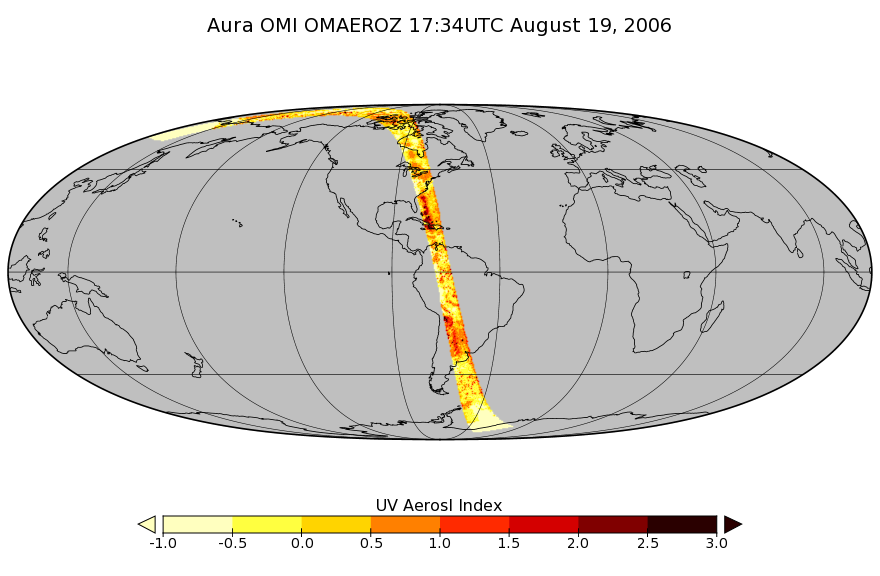
OMI/Aura Aerosol product Multi-wavelength Algorithm Zoomed 1-Orbit L2 Swath 13x12km V003 (OMAEROZ) at GES DISC
National Aeronautics and Space Administration —
The reprocessed OMI/Aura Level-2 Zoomed Aerosol data product OMAEROZ at 13x12 km resolution have been made available from the NASA Goddard Earth Sciences Data and... -
Federal
OMI/Aura Chlorine Dioxide (OClO) Total Column 1-orbit L2 Swath 13x24 km V003 (OMOCLO) at GES DISC
National Aeronautics and Space Administration —
The Aura Ozone Monitoring Instrument (OMI) collection-3 Chlorine Dioxide Product OMOCLO is now available from the NASA Goddard Earth Sciences Data and Information... -
Federal
OMPS/NPP PCA SO2 Total Column 1-Orbit L2 Swath 50x50km NRT
National Aeronautics and Space Administration —
The OMPS-NPP L2 NM Sulfur Dioxide (SO2) Total and Tropospheric Column swath orbital collection 2 version 2.0 product contains the retrieved sulfur dioxide (SO2)... -
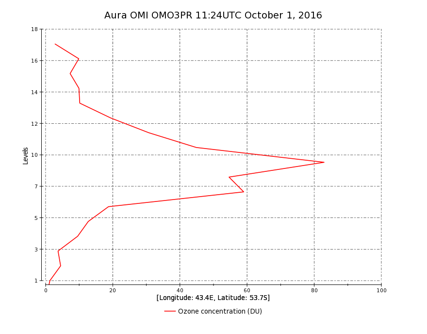
Federal
OMI/Aura Ozone (O3) Profile 1-Orbit L2 Swath 13x48km V003 (OMO3PR) at GES DISC
National Aeronautics and Space Administration —
The Aura Ozone Monitoring Instrument Level-2 Ozone Profile data product OMO3PR (Version 003) is now available from the NASA Goddard Earth Sciences Data and... -
Federal
SAFARI 2000 Cloud Absorption Radiometer BRDF, Dry Season 2000
National Aeronautics and Space Administration —
This record links to the web page for the Cloud Absorption Radiometer (CAR) data for the SAFARI 2000 project. Twenty-one flights were undertaken over Southern Africa... -
Federal
OMI/Aura TOMS-Like Ozone, Aerosol Index, Cloud Radiance Fraction L3 1 day 1 degree x 1 degree V3 (OMTO3d) at GES DISC
National Aeronautics and Space Administration —
The OMI science team produces this Level-3 daily global TOMS-Like Total Column Ozone gridded product OMTO3d (1 deg Lat/Lon grids). The OMTO3d product is produced by... -
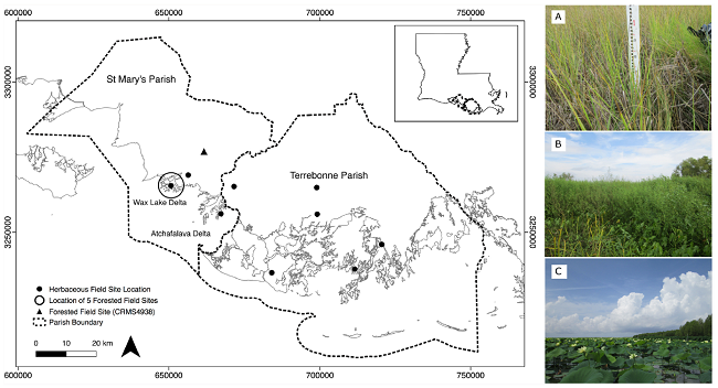
Federal
Pre-Delta-X: Vegetation Species, Structure, Aboveground Biomass, MRD, LA, USA, 2015
National Aeronautics and Space Administration —
This dataset provides vegetation species, height, stem density and diameter, and species aboveground biomass (AGB) measurements collected at herbaceous and forested... -
Federal
QuikSCAT Level 2B Ocean Wind Vectors in 12.5km Slice Composites Version 3.1
National Aeronautics and Space Administration —
This dataset contains the latest reprocessed version 3.1 of the Level 2B science-quality ocean surface wind vector retrievals from the QuikSCAT scatterometer. The... -
Federal
SENTINEL-1B_RAW
National Aeronautics and Space Administration —
Sentinel-1B level zero product -
Federal
SENTINEL-1B_OCN
National Aeronautics and Space Administration —
Sentinel-1B Level 2 Ocean wind, wave and current data -
Federal
Satellite Laser Ranging (SLR) Predictions from NASA CDDIS
National Aeronautics and Space Administration —
Predicted satellite orbits for Satellite Laser Ranging (SLR) tracking of satellites equipped with corner cube retroreflectors. SLR stations download these prediction... -
Federal
MLS/Aura Level 3 Daily Binned Ozone (O3) Mixing Ratio on Assorted Grids V005 (ML3DBO3) at GES DISC
National Aeronautics and Space Administration —
ML3DBO3 is the EOS Aura Microwave Limb Sounder (MLS) daily binned on various vertical grids product for ozone (O3) derived from radiances measured by the 240 GHz...

Official websites use .gov
A
.gov website belongs to an official government
organization in the United States.
Secure .gov websites use HTTPS
A
lock (
) or https:// means you’ve safely connected to
the .gov website. Share sensitive information only on official,
secure websites.