
-
Federal
BOREAS TE-23 Map Plot Data
National Aeronautics and Space Administration —
The BOREAS TE-23 team collected map plot data in support of its efforts to characterize and interpret information on canopy architecture and understory cover at the... -
Federal
The Seven-Year Swift-XRT Point Source Catalog (1SWXRT)
National Aeronautics and Space Administration —
This table contains the 1SWXRT catalog of point sources detected by X-ray Telescope (XRT) on board of the Swift satellite during the first seven years of operation... -
Federal
Combined ASTER and MODIS Emissivity database over Land (CAMEL) Covariances Climatology Monthly Global 0.25Deg V003
National Aeronautics and Space Administration —
The NASA Making Earth System Data Records for Use in Research Environments (MEaSUREs)... -
Federal
TWINS 1 Images of Plasma Sheet Ion Temperature during Storms calculated from Energetic Neutral Atom (ENA) Measurements
National Aeronautics and Space Administration —
TWINS, Two Wide-angle Imaging Neutral-atom Spectrometers, is a Mission of Opportunity under NASA's Small Explorer, SMEX, Program. TWINS-1 and TWINS-2 are the... -
Federal
ISIS-1 Topside Sounder Average Ionogram over Orroral, Australia: ORR, Latitude -36, Longitude 149
National Aeronautics and Space Administration —
This Ionogram was digitized from the original ISIS 1 Analog Telemetry Data on 7-Track Tape using the Facilities of the Data Evaluation Laboratory at NASA GSFC, Code... -
Federal
CERES Time-Interpolated TOA Fluxes, Clouds and Aerosols Daily NOAA-20 Edition1B
National Aeronautics and Space Administration —
The Clouds and the Earth's Radiant Energy System (CERES) Single Scanner Footprint One Degree (SSF1deg) Day provides daily averages of regional constant meteorology... -
Federal
Northern Balearic (NORBAL) Sea measurements in 2002
National Aeronautics and Space Administration —
Measurements made in the Northern Balearic Sea in 2002 and 2003. -
Federal
CYGNSS Level 3 Storm Centric Grid Science Data Record Version 1.0
National Aeronautics and Space Administration —
This dataset contains the Version 1.0 Cyclone Global Navigation Satellite System (CYGNSS) Level 3 Storm Centric Grid (SCG) Science Data Record (SDR) which provides... -
Federal
KPBZ NEXRAD IMPACTS V1
National Aeronautics and Space Administration —
The KPBZ NEXRAD IMPACTS dataset consists of Next Generation Weather Radar (NEXRAD) Level II surveillance data that were collected at 31 NEXRAD sites from January 1 to... -
Federal
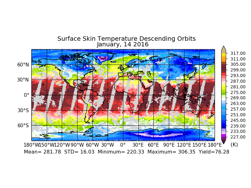
MLS/Aura Level 2 Diagnostics, Geophysical Parameter Grid V004 (ML2DGG) at GES DISC
National Aeronautics and Space Administration —
ML2DGG is the EOS Aura Microwave Limb Sounder (MLS) product containing geophysical diagnostic quantities pertaining directly to the standard geophysical data... -
Federal
IMAGE RPI Monthly Electron Density Values
National Aeronautics and Space Administration —
The electron density values listed in this file are derived from the IMAGE Radio Plasma Imager (B.W. Reinisch, PI) data using an automatic fitting program written by... -
Federal
Spitzer Extragalactic First Look Survey SDSS Spectroscopic Catalog
National Aeronautics and Space Administration —
The Extragalactic First Look Survey is composed of 4 square degrees of imaging with MIPS and IRAC centered at J1718+5930, with extensive ancillary data from ground-... -
Federal
INTEGRAL IBIS Hard X-Ray Survey Above 100 keV Source Catalog
National Aeronautics and Space Administration —
This table contains results from an all-sky survey, performed by the Imager on-Board the INTEGRAL Satellite (IBIS) telescope on board the INTErnational Gamma-Ray... -
Federal
UAVSAR_POLSAR_ML_COMPLEX_GRD_3X3
National Aeronautics and Space Administration —
UAVSAR PolSAR Scene Projected Multilook 3x3 -
Federal
Sounder SIPS: AQUA AIRS IR-only Level 3 CLIMCAPS: Specific Quality Control Gridded Daily V2 (SNDRAQIL3SDCCP) at GES DISC
National Aeronautics and Space Administration —
WARNING: Users of the derived product “co_mmr_midtrop” (carbon monoxide mass mixing ratio to dry air [kg/kg] at ~500 hPa). This variable has a significant bias due to... -
Federal
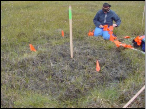
Arctic Vegetation Plots at Frost Boil Sites, North Slope, Alaska, 2000-2006
National Aeronautics and Space Administration —
This data set describes the environment, soil, and vegetation on nonsorted circles and earth hummocks at seven study sites along a N-S-transect from the Arctic Ocean... -
Federal
MODIS/Terra Near Real Time L3 Value-added Aerosol Optical Depth
National Aeronautics and Space Administration —
MODIS was launched aboard the Terra satellite on December 18, 1999 (10:30 am equator crossing time) as part of NASA's Earth Observing System (EOS) mission. MODIS with... -
Federal
LAI (Indirect): Light Wand - KSU (FIFE)
National Aeronautics and Space Administration —
The prairie is inherently variable and large numbers of samples are needed to obtain reliable estimates of the prairie agronomic characteristics. For the Indirect... -
Federal
ATTREX Global Hawk UAS In-Situ Trace Gas Measurements
National Aeronautics and Space Administration —
ATTREX-Aircraft_insitu_TraceGas_Measurements are in-situ trace gas measurements collected onboard the Global Hawk Uninhabited Aerial System (UAS) during the Airborne... -
Federal
ISEE 3 64-min Trajectory Data
National Aeronautics and Space Administration —
This data set was generated at NSSDC by selecting data parameters from the ISEE 3 data pool tape (binary) and converting to ASCII. The time resolution is about an...

Official websites use .gov
A
.gov website belongs to an official government
organization in the United States.
Secure .gov websites use HTTPS
A
lock (
) or https:// means you’ve safely connected to
the .gov website. Share sensitive information only on official,
secure websites.