
-
Federal
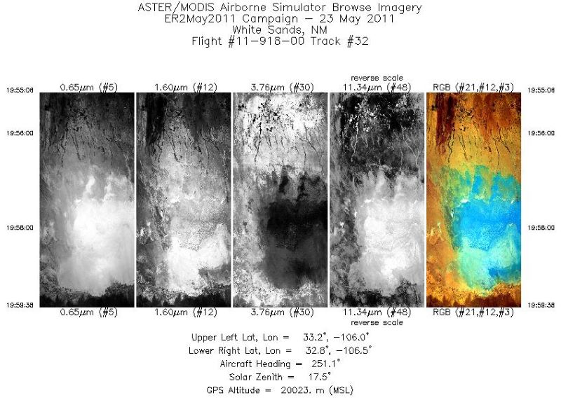
Spitzer Wide-area InfraRed Extragalactic Survey Lockman Hole Optical-IRAC-MIPS24 Catalog
National Aeronautics and Space Administration —
The Spitzer Wide-area InfraRed Extragalactic survey (SWIRE), the largest Spitzer Legacy program, is a wide-area, imaging survey to trace the evolution of dusty, star-... -
Federal
VIIRS/JPSS1 BRDF/Albedo BSA at Solar Noon ShortWave Daily L3 Global 30ArcSec CMG V002
National Aeronautics and Space Administration —
The NOAA-20 Visible Infrared Imaging Radiometer Suite (VIIRS) Bidirectional Reflectance Distribution Function (BRDF) and Albedo Black-Sky Albedo for ShortWave... -
Federal
WISE 3-Band Cryo Source Working Database
National Aeronautics and Space Administration —
The WISE 3-Band Cryo Source Working Database (WDB) contains positions and photometry in the 3.4, 4.6 and 12 μm bands for 261,418,479 sources extracted from... -
Federal
LMC 30 Doradus Complex Chandra X-Ray Point Source Catalog
National Aeronautics and Space Administration —
This table contains the results of a study of the X-ray point-source population of the 30 Doradus (30 Dor) star-forming complex in the Large Magellanic Cloud (LMC)... -
Federal
ECCO Sea-Ice Velocity - Daily Mean llc90 Grid (Version 4 Release 4)
National Aeronautics and Space Administration —
This dataset provides daily-averaged sea-ice velocity on the native Lat-Lon-Cap 90 (LLC90) model grid from the ECCO Version 4 Release 4 (V4r4) ocean and sea-ice state... -
Federal
Vega 2 Trajectory Data
National Aeronautics and Space Administration —
Daily Vega 2 position data in Solar Ecliptic and HGI coordinates. -
Federal
CLASH 4.5 micron Catalog
National Aeronautics and Space Administration —
The Cluster Lensing And Supernova survey with Hubble (CLASH) Multi-Cycle Treasury program (PI: Marc Postman) completed its Hubble Space Telescope (HST)... -
Federal
SBUV2/NOAA-9 Ozone (O3) Profile and Total Column Ozone 1 Month Zonal Mean L3 Global 5.0 degree Latitude Zones V1 (SBUV2N09L3zm) at GES DISC
National Aeronautics and Space Administration —
The Solar Backscattered Ultraviolet (SBUV) from NOAA-9 Level-3 monthly zonal mean (MZM) product (SBUV2N17L3zm) is derived from the Level-2 retrieved ozone profiles.... -
Federal
SDO/AIA 4500 Angstrom FITS Data
National Aeronautics and Space Administration —
The SDO/AIA 4500 Å Level 1 FITS Data. The 4500 Å channel observes the continuum from the photosphere. \n\nThe Atmospheric Imaging Assembly (AIA) onboard Solar... -
Federal
MAVEN SEP Calibrated Ion and Electron Spectra Data Collection (Sensor 2)
National Aeronautics and Space Administration —
Calibrated MAVEN Solar Energetic Particle (SEP) Instrument Sensor 2 ion and electron spectra. The data include total (integrated) and differential (as a function of... -
Federal
Toward countering muscle and bone loss with spaceflight: GSK3 as a potential target (Tibialis Anterior, RR9, Western Blot)
National Aeronautics and Space Administration —
We examined the effects of ~30 days of spaceflight on glycogen synthase kinase 3 (GSK3) content and inhibitory serine phosphorylation in murine muscle and bone... -
Federal
TROPICS05 L2A Unified Resolution Brightness Temperatures V0.2
National Aeronautics and Space Administration —
The "Time-Resolved Observations of Precipitation structure and storm Intensity with a Constellation of Smallsats" (TROPICS) mission has a goal of providing nearly... -
Federal
SENTINEL-1A_SINGLE_POL_GRD_FULL_RES
National Aeronautics and Space Administration —
Sentinel-1A Single-pol ground range detected full resolution images -
Federal
SDO/HMI Linewidth, 720-Second Data
National Aeronautics and Space Administration —
The linewidth observable refers to the FWHM of the (assumed) Gaussian absorption line profile for the 6173.3 Å line on the surface of the sun.\n\nHMI samples the Fe I... -
Federal
VIIRS/JPSS2 Day/Night Band 6-Min L1B Swath SDR 750m NRT
National Aeronautics and Space Administration —
The Near Real Time (NRT) VIIRS Level 1 and Level 2 swath (VJ202DNB_NRT) product is single NASA VIIRS panchromatic Day-Night band (DNB) calibrated radiance product.... -
Federal
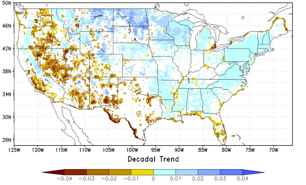
NCA-LDAS Noah-3.3 Land Surface Model L4 Trends 0.125 x 0.125 degree V2.0 (NCALDAS_NOAH0125_Trends) at GES DISC
National Aeronautics and Space Administration —
The National Climate Assessment - Land Data Assimilation System, or NCA-LDAS, is a terrestrial water reanalysis in support of the United States Global Change Research... -
Federal
Alpha Jet Atmospheric eXperiment Formaldehyde Data
National Aeronautics and Space Administration —
The Alpha Jet Atmospheric eXperiment (AJAX) is a partnership between NASA's Ames Research Center and H211, L.L.C., facilitating routine in-situ measurements over... -
Federal
TROPESS CrIS-SNPP L2 for Los Angeles Megacity, Standard Product V1 (TRPSDL2ALLCRSMGLOS) at GES DISC
National Aeronautics and Space Administration —
The TROPESS CrIS-SNPP L2 for Los Angeles Megacity, Standard Product contains the vertical distribution of seven retrieved atmospheric gases (CH4, CO, H2O, HDO, NH3,... -
Federal
AirMOSS: L2/3 Volumetric Soil Moisture Profiles Derived From Radar, 2012-2015
National Aeronautics and Space Administration —
This data set provides level 2/3 root zone soil moisture (RZSM) estimates at multiple depths at 90-m spatial resolution from the Airborne Microwave Observatory of...

Official websites use .gov
A
.gov website belongs to an official government
organization in the United States.
Secure .gov websites use HTTPS
A
lock (
) or https:// means you’ve safely connected to
the .gov website. Share sensitive information only on official,
secure websites.