
-
Federal
2MASS Survey Merged Extended Source Information Table
National Aeronautics and Space Administration —
The merged source tables contain the mean positions magnitudes and uncertainties for sources detected multiple times in each of the 2MASS data sets. The merging was... -
Federal
MISR radiometric camera-by-camera Cloud Mask subset for the UAE region V004
National Aeronautics and Space Administration —
UAEMIRCM_004 is the Multi-angle Imaging SpectroRadiometer (MISR) radiometric camera-by-camera Cloud Mask subset for the UAE region version 4. It contains the... -
Federal
Pioneer Venus Orbiter(PVO) hourly averaged plasma data
National Aeronautics and Space Administration —
This data set holds hourly data for the interplanetary solar wind near Venus from the Plasma Analyzer (OPA) \nexperiment on the Pioneer Venus Orbiter spacecraft. Data... -
Federal
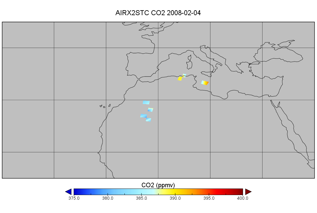
AIRS/Aqua L2 CO2 in the free troposphere (AIRS+AMSU) V005 (AIRX2STC) at GES DISC
National Aeronautics and Space Administration —
The Atmospheric Infrared Sounder (AIRS) is a grating spectrometer (R = 1200) aboard the second Earth Observing System (EOS) polar-orbiting platform, EOS Aqua. In... -
Federal
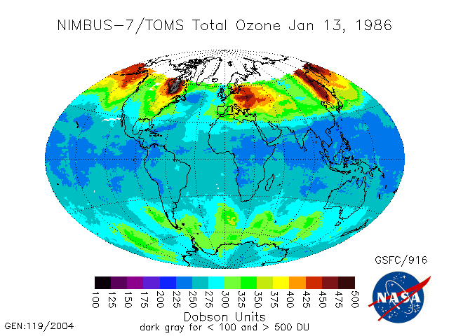
TOMS Nimbus-7 Total Column Ozone Daily L3 Global 1 deg x 1.25 deg Lat/Lon Grid V008 (TOMSN7L3dtoz) at GES DISC
National Aeronautics and Space Administration —
This Nimbus-7 Total Ozone Mapping Spectrometer (TOMS) version 8 daily global gridded data product contains total column ozone values. The data are mapped to a global... -
Federal
Polar Radiant Energy in the Far InfraRed Experiment (PREFIRE) Satellite 1 Raw Curated Payload R01
National Aeronautics and Space Administration —
Polar Radiant Energy in the Far InfraRed Experiment (PREFIRE) Satellite 1 Raw Curated Payload (PREFIRE_SAT1_0-PAYLOAD-TLM) contains the curated raw measurements from... -
Federal
LBA-ECO ND-02 Soil Volumetric Water Content, Tapajos National Forest, Brazil
National Aeronautics and Space Administration —
This data set reports monthly measured soil volumetric water content (VWC) from a rainfall exclusion experiment that was conducted from 1999-2001 at the km 67 Seca... -
Federal
CYGNSS Level 2 Ocean Surface Heat Flux Climate Data Record Version 1.2
National Aeronautics and Space Administration —
This dataset contains the third release, Version 1.2, of the CYGNSS Level 2 Ocean Surface Heat Flux Climate Data Record (CDR), which provides the time-tagged and... -
Federal
LOFAR Radio Catalog of Herschel-ATLAS North Galactic Pole Field
National Aeronautics and Space Administration —
This table contains some of the results of Low-Frequency Array (LOFAR) High-Band Array (HBA) observations of the Herschel-ATLAS North Galactic Pole (NGP) survey area.... -
Federal
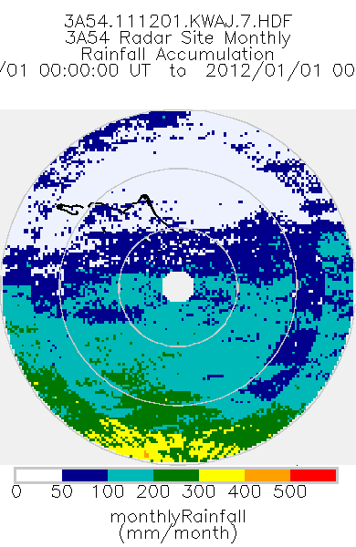
TRMM Ground Validation Radar Site Rain Type Totals Map L3 1 month 2 km V7 (TRMM_3A54) at GES DISC
National Aeronautics and Space Administration —
The 3A54 product, 'Site Rainfall Map', is a map of monthly surface rain totals derived from the instantaneous rain rate maps (2A53). The map is in Cartesian... -
Federal
Global Navigation Satellite System (GNSS) IGS Final Analysis Center (AC) Station Positions/Velocities (no covariance matrix) product from NASA CDDIS - Cloned
National Aeronautics and Space Administration —
This derived product set consists of Global Navigation Satellite System Final Combined Station Positions/Velocities (no covariance matrix) Product available from the... -
Federal
AIRS/Aqua L3 8-day CO2 in the free troposphere (AIRS-only) 2.5 degrees x 2 degrees V005 (AIRS3C28) at GES DISC
National Aeronautics and Space Administration —
The Atmospheric Infrared Sounder (AIRS) is a grating spectrometer (R = 1200) aboard the second Earth Observing System (EOS) polar-orbiting platform, EOS Aqua. In... -
Federal
VIIRS/JPSS1 Land Surface Temperature/Emissivity 8-Day L3 Global 0.05Deg CMG V002
National Aeronautics and Space Administration —
The NOAA-20 Visible Infrared Imaging Radiometer Suite (VIIRS) Land Surface Temperature and Emissivity (LST&E) 8-day Climate Modeling Grid Version 2 product... -
Federal
Ulysses Trajectory Data SEDR
National Aeronautics and Space Administration —
This trajectory data set is provided by NSSDC. NSSDC has been actively supporting the Ulysses mission from the start by providing up-to-date trajectory-related data... -
Federal
VIIRS/NPP BRDF/Albedo WSA at Solar Noon Band M7 Daily L3 Global 30ArcSec CMG V002
National Aeronautics and Space Administration —
The NASA/NOAA Suomi National Polar-orbiting Partnership (Suomi NPP) Visible Infrared Imaging Radiometer Suite (VIIRS) Bidirectional Reflectance Distribution Function... -
Federal
International Satellite Cloud Climatology Project (ISCCP) Stage B3 Reduced Radiances in Native Format
National Aeronautics and Space Administration —
The ISCCP_B3_NAT data is the International Satellite Cloud Climatology Project (ISCCP) Stage B3 Reduced Radiances in Native Format data product. This is the original... -
Federal
Amazon River Basin Precipitation, 1972-1992
National Aeronautics and Space Administration —
The Amazon River Basin precipitation grids were derived from data which was collected daily by the gauging network operated by the Divisao Nacional de Aguas e Energia... -
Federal
Voyager 2 Planetary Radio Astronomy (PRA) Lowband Receiver Jupiter encounter, 6 sec resolution
National Aeronautics and Space Administration —
\n (Description based on material from VG2_PRA_JUP_HRES_DS.CAT)\n\n Voyager 2 Radio Astronomy (PRA) data from the Jupiter encounter (1979-04-25 to 1979-08-04). \n The... -
Federal
Airborne Surface Profiling of Alaskan Glaciers, 1994 - 2001, Version 1
National Aeronautics and Space Administration —
This data set consists of glacier outline, laser altimetry profile, and surface elevation change data for 46 glaciers in Alaska and British Columbia, Canada, measured... -
Federal
SMEX04 Landsat Thematic Mapper Imagery, Sonora, Version 1
National Aeronautics and Space Administration —
This data set provides imagery developed from Landsat 5 Thematic Mapper (TM) data for use in studying land cover features during the Soil Moisture Experiment 2004...

Official websites use .gov
A
.gov website belongs to an official government
organization in the United States.
Secure .gov websites use HTTPS
A
lock (
) or https:// means you’ve safely connected to
the .gov website. Share sensitive information only on official,
secure websites.