
-
Federal
WISE All-Sky Reject Table
National Aeronautics and Space Administration —
NASA's Wide-field Infrared Survey Explorer (WISE; Wright et al. 2010) mapped the sky at 3.4, 4.6, 12, and 22 μm (W1, W2, W3, W4) in 2010 with an angular resolution of... -
Federal
Gold Level L2 Solar EUV proxy
National Aeronautics and Space Administration —
The GOLD solar irradiance proxy (QEUV) is a proxy for the integrated solar EUV \n irradiance below 45 nm, which can be derived directly from far ultraviolet (FUV)... -
Federal
VIIRS/JPSS1 BRDF/Albedo NBAR at Solar Noon Band M11 Daily L3 Global 30ArcSec CMG V002
National Aeronautics and Space Administration —
The NOAA-20 Visible Infrared Imaging Radiometer Suite (VIIRS) Bidirectional Reflectance Distribution Function (BRDF) and Albedo Nadir BRDF-Adjusted Reflectance (NBAR)... -
Federal
BOREAS AFM-02 Wyoming King Air 1994 Aircraft Sounding Data
National Aeronautics and Space Administration —
The BOREAS AFM-02 team used the University of Wyoming King Air aircraft during IFCs 1, 2, and 3 in 1994 to collected pass-by-pass fluxes (and many other statistics)... -
Federal
BARREL 2X X-ray Spectrometer (FSPC) Bremsstrahlung X-ray Spectrum Fast Time Resolution, Level 2, 0.05 s Data
National Aeronautics and Space Administration —
FSPC: Six channels of fast time resolution, 50 ms, Bremsstrahlung X-ray spectra detected with a NaI Scintillator. Each channel is separated in its own variable:... -
Federal
SARP 2014 Data
National Aeronautics and Space Administration —
SARP_2014_Data is the data collected onboard the NASA DC-8 aircraft during the 2014 deployment of the Student Airborne Research Program (SARP) mission. Data... -
Federal
DeepDrill XMM-LSS 4.5 micron Catalog
National Aeronautics and Space Administration —
The Vera C. Rubin Observatory Legacy Survey of Space and Time (LSST) will observe several Deep Drilling Fields (DDFs) to a greater depth and with a more rapid cadence... -
Federal
Swift Gamma-ray Urgent Archiver for Novel Opportunities (GUANO) Events
National Aeronautics and Space Administration —
The Swift Observatory provides event-level data from the Burst Alert Telescope (BAT) on demand in response to transients detected by other observatories/instruments.... -
Federal
ATMOS L2 Trace Gases on Potential Temperature Grid, Fixed Field Format V3 (ATMOSL2TF) at GES DISC
National Aeronautics and Space Administration —
This is the version 3 Atmospheric Trace Molecule Spectroscopy (ATMOS) Level 2 product containing trace gases on a vertical potential temperature (theta) grid with... -
Federal
RSS SMAP Level 3 Sea Surface Salinity Standard Mapped Image 8-Day Running Mean V5.0 Validated Dataset
National Aeronautics and Space Administration —
The version 5.0 SMAP-SSS level 3, 8-Day running mean gridded product is based on the fifth release of the validated standard mapped sea surface salinity (SSS) data... -
Federal
GLIMPSE SMOG Catalog
National Aeronautics and Space Administration —
The Spitzer Mapping of the Outer Galaxy (SMOG; Carey et al. 2008) project mapped a 21 square degree area with IRAC & MIPS (l=102d to 109d , b=0d to 3d) of the... -
Federal
SDO/EVE Level 3 Version 8 Mission-Long Data
National Aeronautics and Space Administration —
EVE level 3 data files were created at the Laboratory for Atmospheric and Space Physics in Boulder, Colorado for the NASA Solar Dynamics Observatory (SDO) Extreme... -
Federal
SDO/HMI Data Products at JSOC/Stanford U.
National Aeronautics and Space Administration —
The HMI-AIA (Helioseismic and Magnetic Imager -\nAtmospheric Imaging Assembly) JSOC (Joint Science Operations Center) \nat Stanford University archives, and provides... -
Federal
VIIRS/JPSS1 BRDF/Albedo Parameter 1 Band M8 Daily L3 Global 30 ArcSec CMG V002
National Aeronautics and Space Administration —
The NOAA-20 Visible Infrared Imaging Radiometer Suite (VIIRS) Bidirectional Reflectance Distribution Function (BRDF) and Albedo Model Parameter 1 Band M8 product... -
Federal
GPM GROUND VALIDATION METEOROLOGICAL TOWER ENVIRONMENT CANADA GCPEX V1
National Aeronautics and Space Administration —
The GPM Ground Validation Meteorological Tower Environment Canada GCPEx dataset provides temperature, relative humidity, 10 m winds, pressure and solar radiation data... -
Federal
SENTINEL-1A_METADATA_SLC
National Aeronautics and Space Administration —
Metadata for Sentinel-1A slant-range product -
Federal
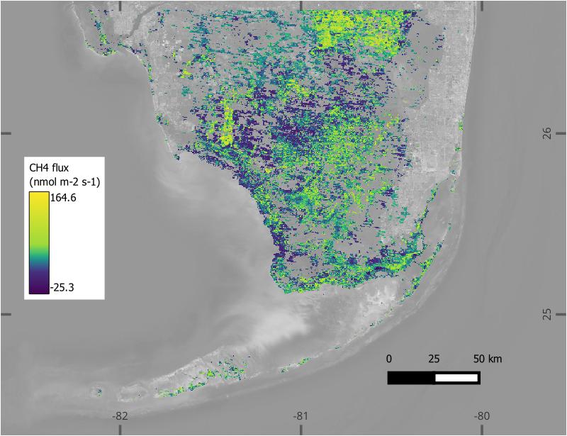
BlueFlux: Modeled Daily CO2 and CH4 Wetland Fluxes, Southern Florida, 2000-2024
National Aeronautics and Space Administration —
This dataset contains gridded estimates of carbon dioxide (CO2) and methane (CH4) fluxes at daily resolution covering the Southern Florida region from 2000 to 2024.... -
Federal
GPM GROUND VALIDATION PRECIPITATION VIDEO IMAGER (PVI) GCPEX V1
National Aeronautics and Space Administration —
The GPM Ground Validation Precipitation Video Imager (PVI) GCPEx dataset collected precipitation particle images and drop size distribution data from November 2011... -
Federal
SAFARI 2000 MODIS MOD05_L2 Water Vapor Data, Binary Format, for Southern Africa
National Aeronautics and Space Administration —
The Moderate Resolution Imaging Spectroradiometer (MODIS) precipitable water product consists of vertical column water-vapor amounts in centimeters (cm) at 1-km... -
Federal
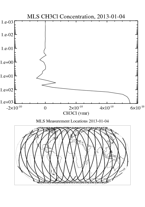
MLS/Aura Level 2 Methyl Chloride (CH3CL) Mixing Ratio V004 (ML2CH3CL) at GES DISC
National Aeronautics and Space Administration —
ML2CH3CL is the EOS Aura Microwave Limb Sounder (MLS) standard product for methyl chloride derived from radiances measured by the 640 GHz radiometer. The data version...

Official websites use .gov
A
.gov website belongs to an official government
organization in the United States.
Secure .gov websites use HTTPS
A
lock (
) or https:// means you’ve safely connected to
the .gov website. Share sensitive information only on official,
secure websites.