
-
Federal
NOAA-11 AVHRR Atmospherically Corrected Normalized Difference Vegetation Index Daily L3 Global 0.05 Deg. CMG
National Aeronautics and Space Administration —
The Long-Term Data Record (LTDR) produces, validates, and distributes a global land surface climate data record (CDR) that uses both mature and well-tested algorithms... -
Federal
LBA-ECO LC-14 Biophysical Measurements, Rainfall Exclusion, Tapajos National Forest
National Aeronautics and Space Administration —
This data set reports forest biophysical measurements from a rainfall exclusion experiment conducted at the km 67 Seca Floresta site, Tapajos National Forest, Brazil... -
Federal
Lamont-Doherty Earth Observatory measurements from the South Atlantic Ocean (ATL)
National Aeronautics and Space Administration —
Measurements from the South Atlantic Ocean (ATL) made by researchers at Columbia Universitys Lamont-Doherty Earth Observatory (LDEO). -
Federal
VIIRS/JPSS1 BRDF/Albedo Valid Observation Band M5 Daily L3 Global 30ArcSec CMG V002
National Aeronautics and Space Administration —
The NOAA-20 Visible Infrared Imaging Radiometer Suite (VIIRS) Bidirectional Reflectance Distribution Function (BRDF) and Albedo Valid Observation Band M5 product... -
Federal
SAMPEX Daily-averaged flux
National Aeronautics and Space Administration —
SAMPEX Daily-averaged flux -
Federal
VIIRS/NPP BRDF/Albedo BSA at Solar Noon DNB Daily L3 Global 30ArcSec CMG V002
National Aeronautics and Space Administration —
The NASA/NOAA Suomi National Polar-orbiting Partnership (Suomi NPP) Visible Infrared Imaging Radiometer Suite (VIIRS) Bidirectional Reflectance Distribution Function... -
Federal
Approaches for Surveying Cosmic Radiation Damage in Large Populations of Arabidopsis thaliana Seeds- an Antarctic Example
National Aeronautics and Space Administration —
The Cosmic Ray Exposure Sequencing Science (CRESS) payload system is a proof of concept experiment to assess the genomic impact of space radiation on seeds. CRESS was... -
Federal
Primary Ancillary Data Geo-Colocated to OMI/Aura VIS 1-Orbit L2 Swath 13x24km V4 (OMVANC) at GES DISC
National Aeronautics and Space Administration —
The Primary Ancillary Data Geo-Colocated to OMI/Aura VIS 1-Orbit L2 Swath 13x24km (OMVANC) provides selected parameters from GEOS-5 Forward Processing for Instrument... -
Federal
NACP MsTMIP: Global 0.5-degree Model Outputs in Standard Format, Version 2.0
National Aeronautics and Space Administration —
This dataset provides an updated version of global gridded estimates of carbon, energy, and hydrologic fluxes between the land and atmosphere from 17 Terrestrial... -
Federal
Spatial Statistical Data Fusion (SSDF) Level 3: CONUS Near-Surface Atmospheric Temperature from Aqua AIRS, V2 (SNDRAQIL3SSDFCNSAT)
National Aeronautics and Space Administration —
This data set provides an estimate of the surface air temperature. It infers a value for each grid point based on nearby and distant values of the input Level-2... -
Federal
SNOE Daily Integrated Values of 2 to 7 nm Solar Soft X-ray Irradiance
National Aeronautics and Space Administration —
This data set was provided by the PI team and contains daily values of the integrated solar X-ray irradiance (2-7 nm) as measured by the SNOE Solar X-ray Photometer.... -
Federal
IMP 4 SPME Energetic Particle Count Rates
National Aeronautics and Space Administration —
IMP 4 SPME hourly >10, >30, >60 MeV proton count rates and 1-10 MeV proton and alpha particle rates, in ASCII via ftp -
Federal
LMC Clusters Catalog
National Aeronautics and Space Administration —
A new catalogue of clusters in the Large Magellanic Cloud has been constructed from searches of the IIIa-J component of the ESO/SERC Southern Sky Atlas. The catalogue... -
Federal
Measurements near Nauru, Micronesia in 1999
National Aeronautics and Space Administration —
Measurements made around the island of Nauru in Micronesia in 1999. -
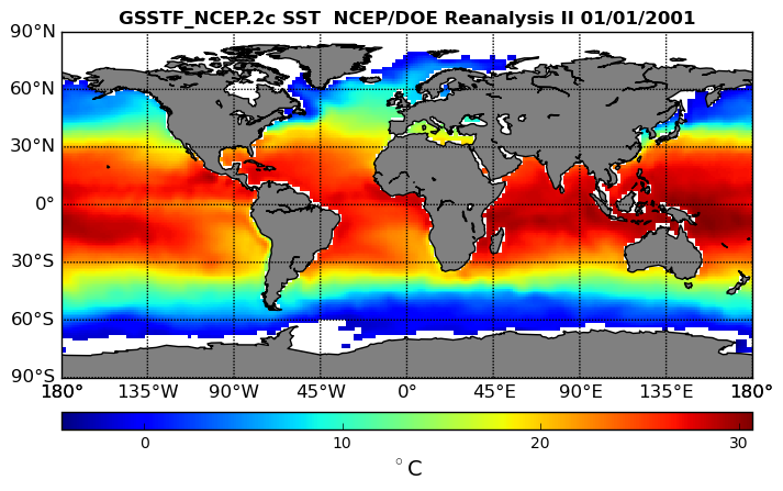
Federal
NCEP/DOE Reanalysis II in HDF-EOS5, for GSSTF2c, 1x1 deg Daily grid V2c (GSSTF_NCEP) at GES DISC
National Aeronautics and Space Administration —
These data are the Goddard Satellite-based Surface Turbulent Fluxes Version-2c (GSSTF2c) Dataset recently produced through a MEaSURES funded project led by Dr. Chung-... -
Federal
Pioneer 10 Magnetometer 1-min data
National Aeronautics and Space Administration —
Pioneer 10 1-min averaged magnetic field vectors in RTN coordinates, cruise phase, ASCII -
Federal
Helios 2 E3 Magnetometer (Ness et al.) 1-hr Data
National Aeronautics and Space Administration —
Task of the HELIOS mission was the exploration of the inner heliosphere, inside the Earth's orbit to 0.3 AU. The Rome-GSFC magnetic field experiment has been a joint... -
Federal
BOREAS Follow-On HMet-01 Level-2 GOES-8 1996 Shortwave and Longwave Radiation
National Aeronautics and Space Administration —
The BOREAS RSS-14 team collected and processed several Level-1 GOES-7 and GOES-8 image data sets for 1994-1996, and GOES-7 Level-2 for 1994 over the BOREAS study... -
Federal
CfA Redshift Survey: South Galactic Cap Data
National Aeronautics and Space Administration —
The Center for Astrophysics (CfA) Redshift Survey South Galactic Cap (CFA2S) Catalog contains redshifts for a sample of about 4300 galaxies with blue (Zwicky B(0)... -
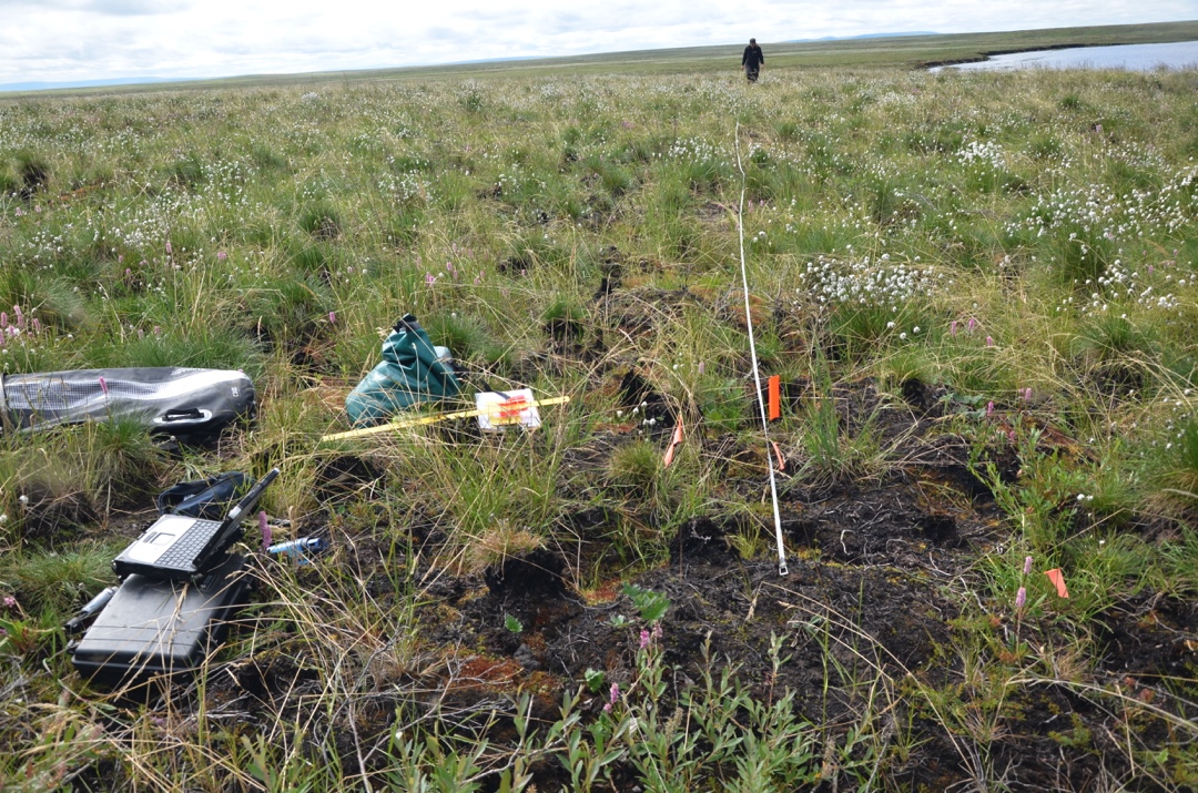
Federal
Arctic Vegetation Plots in Burned and Unburned Tundra, Alaska, 2011-2012
National Aeronautics and Space Administration —
This dataset provides environmental and vegetation data collected in late June and July of 2011 and of 2012 from study plots located in tundra fire scars and adjacent...

Official websites use .gov
A
.gov website belongs to an official government
organization in the United States.
Secure .gov websites use HTTPS
A
lock (
) or https:// means you’ve safely connected to
the .gov website. Share sensitive information only on official,
secure websites.