
-
Federal
Rooftop Energy Potential of Low Income Communities in America REPLICA
Department of Energy —
The Rooftop Energy Potential of Low Income Communities in America REPLICA data set provides estimates of residential rooftop solar technical potential at the tract-... -
Federal
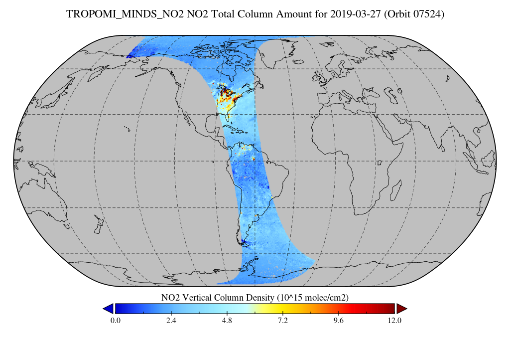
TROPOMI/S5P NO2 Tropospheric, Stratospheric and Total Columns MINDS 1-Orbit L2 Swath 5.5 km x 3.5 km V1.1 (TROPOMI_MINDS_NO2) at GES DISC
National Aeronautics and Space Administration —
As part of the NASA's Making Earth System Data Records for Use in Research Environments (MEaSUREs) program, this project entitled “Multi-Decadal Nitrogen Dioxide and... -
Federal
O'Brien-Lemon Magnetospheric Density Reanalysis Data Set
National Aeronautics and Space Administration —
Retrospective analyses of spacecraft anomalies, especially surface charging, require information about the local plasma environment. Such information is usually not... -
Federal
Circum-Arctic Map of Permafrost and Ground-Ice Conditions, Version 2
National Aeronautics and Space Administration —
The Circum-Arctic permafrost and ground ice map is available via ftp in ESRI Shapefile format and Equal-Area Scalable Earth Grid (EASE-Grid) format. See the Format... -
Federal
Transcriptional profiling of livers from mice flown on Rodent Research Reference Mission-1 (RRRM-1)
National Aeronautics and Space Administration —
In the Rodent Research Reference Mission (RRRM-1), forty female BALB/cAnNTac mice were flown on the International Space Station. To assess differences in outcomes due... -
Federal
Pre-ABoVE: L1 S-0 Polarimetric Data from AirMOSS P-band SAR, Alaska, 2014-2015
National Aeronautics and Space Administration —
This data set provides level 1 (L1) polarimetric radar backscattering coefficient (sigma-0), multi-look complex, polarimetrically calibrated, and georeferenced data... -
Federal
MODIS/Aqua Near Real Time (NRT) L2 Surface Reflectance, 5-Min Swath 250m, 500m, and 1km
National Aeronautics and Space Administration —
MODIS/Aqua Near Real Time (NRT) L2 Surface Reflectance, 5-Min Swath 250m, 500m, and 1km (MYD09). This product is computed from the MODIS Level 1B land bands 1, 2, 3,... -
Federal
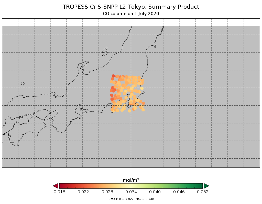
TROPESS CrIS-SNPP L2 for Tokyo Megacity, Summary Product V1 (TRPSYL2ALLCRSMGTOK) at GES DISC
National Aeronautics and Space Administration —
The TROPESS CrIS-SNPP L2 for Tokyo Megacity, Summary Product contains the vertical distribution of six retrieved atmospheric gases (CH4, CO, HDO, NH3, O3 and PAN),... -
Federal
ISLSCP II Global Precipitation Climatology Centre (GPCC) Monthly Precipitation
National Aeronautics and Space Administration —
The Global Precipitation Climatology Centre (GPCC), which is operated by the Deutscher Wetterdienst (National Meteorological Service of Germany), is a component of... -
Federal
BOREAS TE-02 Continuous Wood Respiration Data
National Aeronautics and Space Administration —
The BOREAS TE-02 team collected several data sets in support of its efforts to characterize and interpret information on the respiration of the foliage, roots, and... -
Federal
ISIS-1 Topside Sounder Average Ionogram over Winkfield, United Kingdom: WNK, Latitude 51, Longitude 359
National Aeronautics and Space Administration —
This Ionogram was digitized from the original ISIS 1 Analog Telemetry Data on 7-Track Tape using the Facilities of the Data Evaluation Laboratory at NASA GSFC, Code... -
Federal
GPM Ground Validation Airborne Snow Observatory (ASO) OLYMPEX V1
National Aeronautics and Space Administration —
The GPM Ground Validation Airborne Snow Observatory (ASO) OLYMPEX dataset consists of snow depth, bare earth surface, land surface classification and a Red, Green,... -
Federal
TROPESS CrIS-SNPP L2 Peroxyacetyl Nitrate for Reanalysis Stream, Summary Product V1 (TRPSYL2PANCRSRS) at GES DISC
National Aeronautics and Space Administration —
The TROPESS CrIS-SNPP L2 Peroxyacetyl Nitrate for Reanalysis Stream, Summary Product contains the vertical distribution of the retrieved atmospheric state of... -
Federal
Delta-X: AVIRIS-NG BRDF-Adjusted Surface Reflectance and Mosaics, MRD, LA, 2021, V3
National Aeronautics and Space Administration —
This data provides AVIRIS-NG Bidirectional Reflectance Distribution Function (BRDF) and sunglint-corrected surface spectral reflectance images over the Atchafalaya... -
Federal
Joint Global Ocean Flux Study (JGOFS) Arabian Sea measurements
National Aeronautics and Space Administration —
Joint Global Ocean Flux Study (JGOFS) Arabian Sea measurements from 1994 and 1995. -
Federal
ECCO Gent-McWilliams Bolus Transport Streamfunction - Daily Mean llc90 Grid (Version 4 Release 4)
National Aeronautics and Space Administration —
This dataset provides daily-averaged Gent-McWilliams ocean bolus transport streamfunction on the native Lat-Lon-Cap 90 (LLC90) model grid from the ECCO Version 4... -
Federal
BSCW Grid Depository
National Aeronautics and Space Administration —
Please upload your BSCW grids here. Thank you. -
Federal
VIIRS/JPSS1 BRDF/Albedo WSA at Solar Noon Band M10 Daily L3 Global 30ArcSec CMG V002
National Aeronautics and Space Administration —
The NOAA-20 Visible Infrared Imaging Radiometer Suite (VIIRS) Bidirectional Reflectance Distribution Function (BRDF) and Albedo white-sky albedo for band M10... -
Federal
SARP 2013 Data
National Aeronautics and Space Administration —
SARP_2013_Data is the data collected onboard the NASA DC-8 aircraft during the 2013 deployment of the Student Airborne Research Program (SARP) mission. Data... -
Federal
SMEX02 Land Surface Information: Land Use Classification, Version 1
National Aeronautics and Space Administration —
This data set consists of land use classification data collected for the Iowa Soil Moisture Experiment 2002 (SMEX02) study region. The land use classification image...

Official websites use .gov
A
.gov website belongs to an official government
organization in the United States.
Secure .gov websites use HTTPS
A
lock (
) or https:// means you’ve safely connected to
the .gov website. Share sensitive information only on official,
secure websites.