

193 datasets found
-
Federal
HHS COVID-19 Small Area Estimations Survey - Primary Vaccine Series - Wave 08
U.S. Department of Health & Human Services —
The goal of the Monthly Outcome Survey (MOS) Small Area Estimations (SAE) is to generate estimates of the proportions of adults, by county and month, who were in the... -
City
Proposed Annexation 2017
City of Bloomington —
Proposed 2017 annexation areas for the City of Bloomington used to define and display areas under consideration for annexation. -
City
City Limits
City of Somerville —
ESRI polygon feature class representing the City of Somerville, Massachusetts city boundary. -
County
StreetMidline2015
Cook County of Illinois —
The Street Midlines in this feature class represent the interpreted midline between the compiled edges of pavement. Unimproved rights-of-way are also included in this... -
Federal
HHS COVID-19 Small Area Estimations Survey - Primary Vaccine Series - Wave 02
U.S. Department of Health & Human Services —
The goal of the Monthly Outcome Survey (MOS) Small Area Estimations (SAE) is to generate estimates of the proportions of adults, by county and month, who were in the... -
Federal
HHS COVID-19 Small Area Estimations Survey - Updated Bivalent Vaccine Audience - Wave 28
U.S. Department of Health & Human Services —
The goal of the Monthly Outcome Survey (MOS) Small Area Estimations (SAE) is to generate estimates of the proportions of adults, by county and month, who were in the... -
Federal
HHS COVID-19 Small Area Estimations Survey - Primary Vaccine Series - Wave 11
U.S. Department of Health & Human Services —
The goal of the Monthly Outcome Survey (MOS) Small Area Estimations (SAE) is to generate estimates of the proportions of adults, by county and month, who were in the... -
Federal
HHS COVID-19 Small Area Estimations Survey - Primary Vaccine Series - Wave 24
U.S. Department of Health & Human Services —
The goal of the Monthly Outcome Survey (MOS) Small Area Estimations (SAE) is to generate estimates of the proportions of adults, by county and month, who were in the... -
City
Paving History
City of Bloomington —
This layer is used by public works to track current and previous year's street paving. -
City
Fire Response Districts
City of Somerville —
ESRI polygon feature class representing City of Somerville, Massachusetts fire response districts. -
City
Multiuse Sidepaths
City of Bloomington —
This map layer represents the multiuse pedestrian paths in and around the City of Bloomington, Bloomington. This paths features captures pedestrian features managed... -
City
Police Stations
City of Somerville —
ESRI point feature class representing City of Somerville, Massachusetts police station locations. -
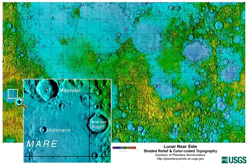
Federal
Gazetteer of Planetary Nomenclature: Moon: 1:10 million-scale Shaded Relief and Color-coded Topography: Near Side
National Aeronautics and Space Administration —
These lunar maps display the four different areas of the moon with color-coded topography in low and high resolution approved by the International Astronomical Union... -
County
Road Services - Map Vault
King County, Washington —
Search for maps and projects managed by King County's Department of Transportation -
Federal
Mesoscale Analy. and Prediction Sys., 60 km grid covering North Am. continent
Department of Energy —
No description found -
Federal
HHS COVID-19 Small Area Estimations Survey - Primary Vaccine Series - Wave 25
U.S. Department of Health & Human Services —
The goal of the Monthly Outcome Survey (MOS) Small Area Estimations (SAE) is to generate estimates of the proportions of adults, by county and month, who were in the... -
County
King County Map Compendium
King County, Washington —
Maps and map applications of all kinds—interactive map viewers, downloadable maps, map collections and more—from all around King County government. -
City
Zoning Districts
City of Bloomington —
This map data layer represents the zoning district boundaries for the City of Bloomington, Indiana as defined through the City's zoning ordinance. The most recent... -
City
Texas Freshwater/Saltwater Boundary
City of Austin —
The following data represents the Texas Freshwater/Saltwater Boundary line.
193 datasets found