
-
Federal
The StreamCat Dataset: Accumulated Attributes for NHDPlusV2 (Version 2.1) Catchments for the Conterminous United States: National Land Cover Database
U.S. Environmental Protection Agency —
This dataset represents data derived from the NLCD dataset and the National Hydrography Dataset version 2.1(NHDPlusV2) (see Data Sources for links to NHDPlusV2 data... -
Federal
EPA Facility Registry Service (FRS): ER_TRI
U.S. Environmental Protection Agency —
This web feature service contains location and facility identification information from EPA's Facility Registry System (FRS) for the subset of facilities that link to... -
Federal
EnviroAtlas - Fruit and vegetable crops by 12-digit HUC for the Conterminous United States
U.S. Environmental Protection Agency —
This EnviroAtlas dataset includes data on the area, yield, and number of fruit and vegetable crops grown per 12-digit Hydrologic Unit (HUC) in the conterminous USA.... -
Federal
NOAA Digital Orthophotography for the Coasts of New York and New Jersey
National Oceanic and Atmospheric Administration, Department of Commerce —
Project: NOAA Digital Orthophotography for the Coasts of Main/New Hampshire, Massachusetts/Rhode Island/Connecticut, and Hudson River/Long Island /NY/NJ Contract No.... -
Federal
Geochemical data generated by projects funded by the USGS Earth Mapping Resources Initiative (ver. 12.0, December 2025)
Department of the Interior —
The geochemical data included here were generated as part of the Earth Mapping Resources Initiative (Earth MRI), which was developed by the U.S. Geological Survey... -
Federal
EnviroAtlas - Public outdoor recreation areas availability and accessibility for the Conterminous United States
U.S. Environmental Protection Agency —
This EnviroAtlas map estimates the accessibility and availability of public outdoor recreational areas (e.g., urban parks, national forests) within 800m along... -
Federal
EPA Facility Registry Service (FRS): ER_FRP
U.S. Environmental Protection Agency —
This dataset contains location and facility identification information from EPA's Facility Registry System (FRS) for the subset of facilities that link to Facility... -
Federal
EnviroAtlas - 2020 Dasymetric Population for the Conterminous United States v1.1
U.S. Environmental Protection Agency —
This EnviroAtlas dataset intelligently reallocates 2020 population from census blocks to 30 meter pixels based on land cover and land use for the conterminous United... -
Federal
EnviroAtlas Estimated Percent Green Space Along Walkable Roads Web Service
U.S. Environmental Protection Agency —
This EnviroAtlas dataset estimates green space along walkable roads. Green space within 25 meters of the road centerline is included and the percentage is based on... -
Federal
EnviroAtlas - Manure application to agricultural lands from confined animal feeding operations by 12-digit HUC for the Conterminous United States, 2006
U.S. Environmental Protection Agency —
This EnviroAtlas dataset contains data on the mean livestock manure application to cultivated crop and hay/pasture lands by 12-digit Hydrologic Unit (HUC) in 2006.... -
Federal
Geochemical and Geospatial Data for Per- and Polyfluoroalkyl Substances (PFAS) in Groundwater Used as a Source of Drinking Water in the Eastern United States
Department of the Interior —
Concentrations of inorganic constituents, dissolved organic carbon (DOC), tritium, per- and polyfluoroalkyl substances (PFAS), volatile organic compounds (VOCs), and... -
Federal
EnviroAtlas - Above Ground Live Tree Biomass Carbon Storage by 12-Digit HUC for the Conterminous United States - Forested
U.S. Environmental Protection Agency —
This EnviroAtlas dataset includes the sum of aboveground live dry biomass estimate by 12-digit Hydrologic Unit (HUC) in total metric tons (megagrams) from the 2000... -
Federal
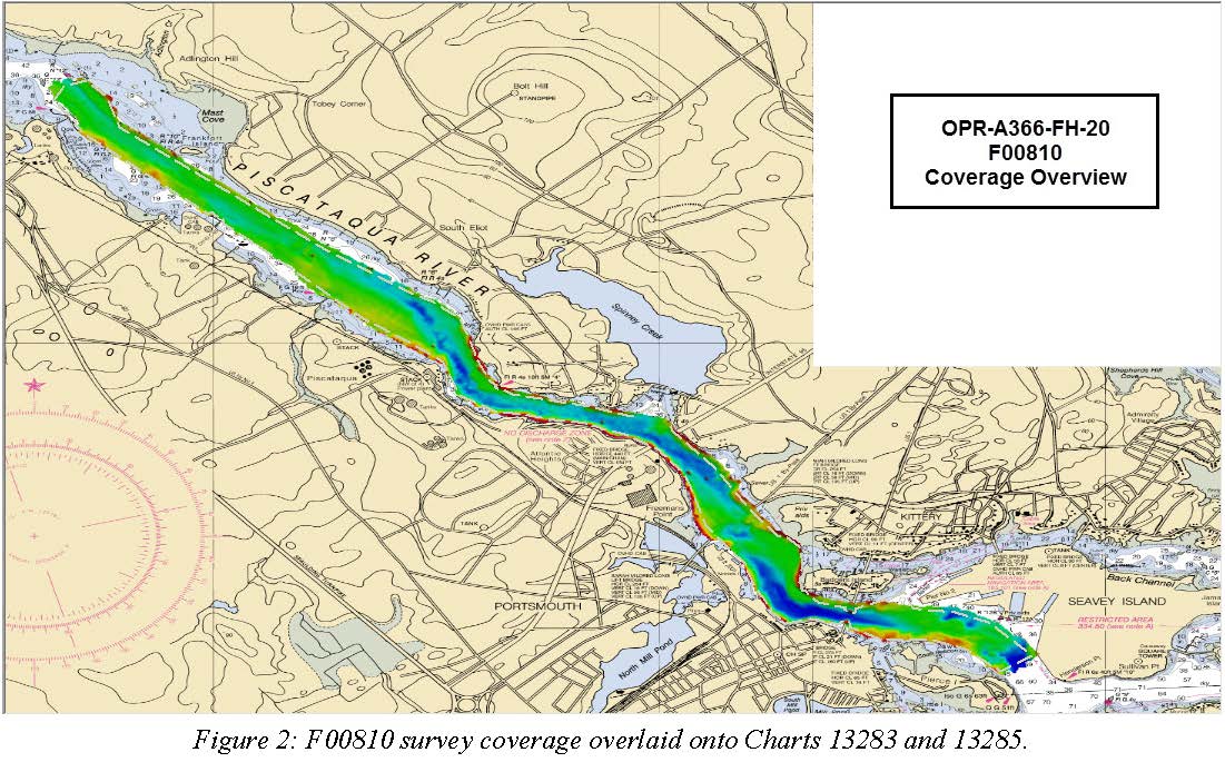
F00810: NOS Hydrographic Survey , 2020-08-05
National Oceanic and Atmospheric Administration, Department of Commerce —
The National Oceanic and Atmospheric Administration (NOAA) has the statutory mandate to collect hydrographic data in support of nautical chart compilation for safe... -
Federal
Data for machine learning predictions of pH in the glacial aquifer system, northern USA
Department of the Interior —
A boosted regression tree (BRT) model was developed to predict pH conditions in three-dimensions throughout the glacial aquifer system (GLAC) of the contiguous United... -
Federal
Demographics for US Census Tracts - 2010 (American Community Survey 2006-2010 Derived Summary Tables)
U.S. Environmental Protection Agency —
This map service displays data derived from the 2006-2010 American Community Survey (ACS). Values derived from the ACS and used for this map service include: Total... -
Federal
2017 NOAA/MCP Topobathy Lidar DEM: Blue Hill Bay, ME - Riegl Sensor
National Oceanic and Atmospheric Administration, Department of Commerce —
Fugro was contracted in July 2017 by the State of Maine Department of Marine Resources (SMDMR), Maine Coastal Program (MCP), and the NOAA Office for Coastal... -
Federal
EnviroAtlas - Portland, ME - 15m Riparian Buffer Forest Cover
U.S. Environmental Protection Agency —
This EnviroAtlas dataset describes the percentage of a 15-m riparian buffer that is forested. There is a potential for decreased water quality in areas where the... -
Federal
A01 Optics - Chlorophyll / Turbidity
National Oceanic and Atmospheric Administration, Department of Commerce —
Ocean observation data from the Northeastern Regional Association of Coastal & Ocean Observing Systems (NERACOOS). The NERACOOS region includes the northeast... -
Federal
US EPA Nonattainment Areas and Designations-PM10 (1987 NAAQS)
U.S. Environmental Protection Agency —
This web service contains the following layer: PM10 Nonattainment Areas (1987 NAAQS). Full FGDC metadata records for each layer may be found by clicking the layer... -
Federal
EnviroAtlas - 2011 Land Cover, Impervious Surface, and Riparian Land Cover Proportions by County for the Conterminous United States
U.S. Environmental Protection Agency —
This EnviroAtlas dataset represents land cover across a county and in riparian areas for each county in the conterminous United States for use in the Compare my Area...

Official websites use .gov
A
.gov website belongs to an official government
organization in the United States.
Secure .gov websites use HTTPS
A
lock (
) or https:// means you’ve safely connected to
the .gov website. Share sensitive information only on official,
secure websites.