
-
Federal
Galveston, Texas Coastal Digital Elevation Model
National Oceanic and Atmospheric Administration, Department of Commerce —
NOAA's National Geophysical Data Center (NGDC) is building high-resolution digital elevation models (DEMs) for select U.S. coastal regions. These integrated... -
Federal
Gravity Anomalies and Estimated Topography Derived from Satellite Altimetry
National Oceanic and Atmospheric Administration, Department of Commerce —
In many areas of the global ocean, the depth of the seafloor is not well known because survey lines by ships are hundreds of kilometers apart. Satellites carrying... -
Federal
F00443: NOS Hydrographic Survey , Charleston Harbor, South Carolina and Adjoining Waterways, South Carolina, 1998-07-29
National Oceanic and Atmospheric Administration, Department of Commerce —
The National Oceanic and Atmospheric Administration (NOAA) has the statutory mandate to collect hydrographic data in support of nautical chart compilation for safe... -
Federal
NCCOS Mapping: Characterizing Benthic Habitats West of Saipan, Commonwealth of the Northern Mariana Islands (CNMI), 2018-11-05 to 2022-04-29 (NCEI Accession 0291792)
National Oceanic and Atmospheric Administration, Department of Commerce —
This data package contains information and maps showing the geology and biology of select submerged lands (0 to 40 meters deep) offshore of western Saipan,... -
Federal
Bathymetric data for Beaver Lake near Rogers, Arkansas, 2018
Department of the Interior —
Beaver Lake was constructed in 1966 on the White River in the northwest corner of Arkansas for flood control, hydroelectric power, public water supply, and... -
Federal
Digital Elevation Model of the Gulf of Mexico, Integrating Bathymetric and Topographic Datasets
National Oceanic and Atmospheric Administration, Department of Commerce —
Modeling and mapping of coastal processes (e.g. tsunamis, hurricane storm-surge, and sea-level rise) requires digital representations of Earth's solid surface,... -
Federal
Columbia River, WA/OR (P260) Bathymetric Digital Elevation Model (30 meter resolution) Derived From Source Hydrographic Survey Soundings Collected by NOAA
National Oceanic and Atmospheric Administration, Department of Commerce —
Bathymetry for the Columbia River was derived from forty-five surveys containing 306,711 soundings. Nine older, overlapping, less accurate surveys were omitted before... -
Federal
F00757: NOS Hydrographic Survey , 2018-11-01
National Oceanic and Atmospheric Administration, Department of Commerce —
The National Oceanic and Atmospheric Administration (NOAA) has the statutory mandate to collect hydrographic data in support of nautical chart compilation for safe... -
Federal
Kawaihae, Hawaii Tsunami Forecast Grids for MOST Model
National Oceanic and Atmospheric Administration, Department of Commerce —
The Kawaihae, Hawaii Forecast Model Grids provides bathymetric data strictly for tsunami inundation modeling with the Method of Splitting Tsunami (MOST) model. MOST... -
Federal
D00239: NOS Hydrographic Survey , 2017-09-15
National Oceanic and Atmospheric Administration, Department of Commerce —
The National Oceanic and Atmospheric Administration (NOAA) has the statutory mandate to collect hydrographic data in support of nautical chart compilation for safe... -
Federal
Continuously Updated Digital Elevation Model (CUDEM) - 1/3 Arc-Second Resolution Bathymetric-Topographic Tiles NGDA
National Oceanic and Atmospheric Administration, Department of Commerce —
NOAA's National Centers for Environmental Information (NCEI) is developing a suite of digital elevation models (DEMs) for the U.S. coast to support a variety of NOAA... -
Federal
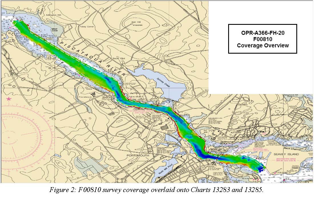
F00810: NOS Hydrographic Survey , 2020-08-05
National Oceanic and Atmospheric Administration, Department of Commerce —
The National Oceanic and Atmospheric Administration (NOAA) has the statutory mandate to collect hydrographic data in support of nautical chart compilation for safe... -
Federal
Coastal Bathymetry Data Collected in 2016 from the Chandeleur Islands, Louisiana–Single Beam Bathymetry Soundings (XYZ)
Department of the Interior —
The U.S. Geological Survey St. Petersburg Coastal and Marine Science Center (USGS SPCMSC), collected single beam and swath bathymetry data from the northern... -
Federal
TEAMER: Long Island Sound Tidal Resource Assessment Geodatabase Model
Department of Energy —
This submission includes the Long Island Sound (LIS) Tidal Energy Resource Geodatabase developed collaboratively by Integral Consulting Inc. and Future Island Impact... -
Federal
Coastal Single-beam Bathymetry Data Collected in August 2018 from the Chandeleur Islands, Louisiana
Department of the Interior —
Scientists from the U.S. Geological Survey St. Petersburg Coastal and Marine Science Center (USGS - SPCMSC) in St. Petersburg, Florida, conducted a single-beam... -
Federal
H07741: NOS Hydrographic Survey , 1949-12-31
National Oceanic and Atmospheric Administration, Department of Commerce —
The National Oceanic and Atmospheric Administration (NOAA) has the statutory mandate to collect hydrographic data in support of nautical chart compilation for safe... -
Federal
H00133A: NOS Hydrographic Survey , 1841-10-19
National Oceanic and Atmospheric Administration, Department of Commerce —
The National Oceanic and Atmospheric Administration (NOAA) has the statutory mandate to collect hydrographic data in support of nautical chart compilation for safe... -
Federal
H06103: NOS Hydrographic Survey , 1936-12-31
National Oceanic and Atmospheric Administration, Department of Commerce —
The National Oceanic and Atmospheric Administration (NOAA) has the statutory mandate to collect hydrographic data in support of nautical chart compilation for safe... -
Federal
H04729: NOS Hydrographic Survey , 1927-12-31
National Oceanic and Atmospheric Administration, Department of Commerce —
The National Oceanic and Atmospheric Administration (NOAA) has the statutory mandate to collect hydrographic data in support of nautical chart compilation for safe... -
Federal
F00036: NOS Hydrographic Survey , 1942-07-12
National Oceanic and Atmospheric Administration, Department of Commerce —
The National Oceanic and Atmospheric Administration (NOAA) has the statutory mandate to collect hydrographic data in support of nautical chart compilation for safe...

Official websites use .gov
A
.gov website belongs to an official government
organization in the United States.
Secure .gov websites use HTTPS
A
lock (
) or https:// means you’ve safely connected to
the .gov website. Share sensitive information only on official,
secure websites.
.jpg)