
-
Federal
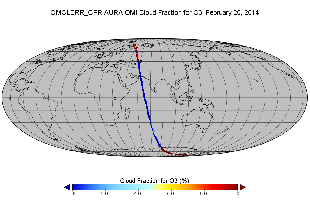
OMI/Aura Cloud Pressure and Fraction (Raman Scattering) 200-km swath subset along CloudSat track V003 (OMCLDRR_CPR) at GES DISC
National Aeronautics and Space Administration —
This is the OMI/Aura Cloud Pressure and Fraction (Raman Scattering) subset along CloudSat tracks, for the purposes of the A-Train mission. The original data product... -
Federal
OMPS-NPP L2 NM Nitrogen Dioxide (NO2) Total and Tropospheric Column swath orbital V2 (OMPS_NPP_NMNO2_L2) at GES DISC
National Aeronautics and Space Administration —
The OMPS-NPP L2 NM Nitrogen Dioxide (NO2) Total and Tropospheric Column swath orbital collection 2 version 2.0 product contains the retrieved nitrogen dioxide (NO2)... -
Federal
OMPS-N20 NM PCA SO2 Step 1 Total Column 1-Orbit L2 Swath 17x13km NRT
National Aeronautics and Space Administration —
The OMPS-N20 NM PCA SO2 Step1 Total Column 1-Orbit L2 Swath 17x13km collection 1 product contains the retrieved sulfur dioxide (SO2) measured by the Ozone Mapping and... -
Federal
OMI/Aura Level 1B UV Zoom-in Geolocated Earthshine Radiances V004 (OML1BRUZ) at GES DISC
National Aeronautics and Space Administration —
The Aura Ozone Monitoring Instrument (OMI) Level 1B (L1B) Geolocated Earthshine UV Radiance, Zoom-mode (shortname OML1BRUZ) Version 4 product contains geolocated... -
Federal
Sounder SIPS: JPSS-1 CrIS Level 3 Comprehensive Quality Control Gridded Monthly CLIMCAPS V2 (SNDRJ1IML3CMCCP) at GES DISC
National Aeronautics and Space Administration —
WARNING: To users of the derived product “co_mmr_midtrop” (carbon monoxide mass mixing ratio to dry air [kg/kg] at ~500 hPa). This variable has a significant bias due... -
Federal
SMEX03 Landsat Thematic Mapper Imagery: Georgia, Version 1
National Aeronautics and Space Administration —
This data set provides imagery developed from Landsat 5 Thematic Mapper (TM) data for use in studying land cover features during the Soil Moisture Experiment 2003... -
Federal
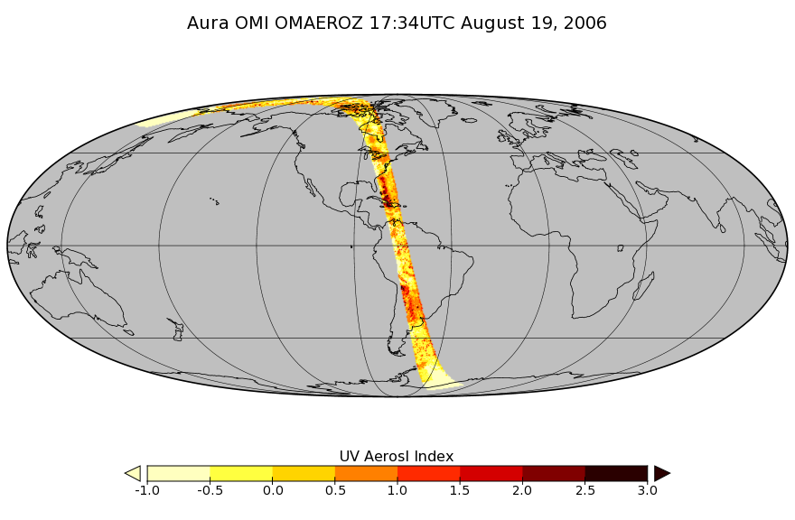
OMI/Aura Aerosol product Multi-wavelength Algorithm Zoomed 1-Orbit L2 Swath 13x12km V003 (OMAEROZ) at GES DISC
National Aeronautics and Space Administration —
The reprocessed OMI/Aura Level-2 Zoomed Aerosol data product OMAEROZ at 13x12 km resolution have been made available from the NASA Goddard Earth Sciences Data and... -
Federal
OMI/Aura Chlorine Dioxide (OClO) Total Column 1-orbit L2 Swath 13x24 km V003 (OMOCLO) at GES DISC
National Aeronautics and Space Administration —
The Aura Ozone Monitoring Instrument (OMI) collection-3 Chlorine Dioxide Product OMOCLO is now available from the NASA Goddard Earth Sciences Data and Information... -
Federal
OMPS/NPP PCA SO2 Total Column 1-Orbit L2 Swath 50x50km NRT
National Aeronautics and Space Administration —
The OMPS-NPP L2 NM Sulfur Dioxide (SO2) Total and Tropospheric Column swath orbital collection 2 version 2.0 product contains the retrieved sulfur dioxide (SO2)... -
Federal
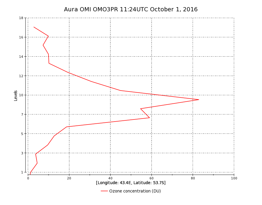
OMI/Aura Ozone (O3) Profile 1-Orbit L2 Swath 13x48km V003 (OMO3PR) at GES DISC
National Aeronautics and Space Administration —
The Aura Ozone Monitoring Instrument Level-2 Ozone Profile data product OMO3PR (Version 003) is now available from the NASA Goddard Earth Sciences Data and... -
Federal
SAFARI 2000 Cloud Absorption Radiometer BRDF, Dry Season 2000
National Aeronautics and Space Administration —
This record links to the web page for the Cloud Absorption Radiometer (CAR) data for the SAFARI 2000 project. Twenty-one flights were undertaken over Southern Africa... -
Federal
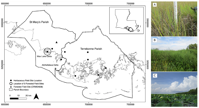
Pre-Delta-X: Vegetation Species, Structure, Aboveground Biomass, MRD, LA, USA, 2015
National Aeronautics and Space Administration —
This dataset provides vegetation species, height, stem density and diameter, and species aboveground biomass (AGB) measurements collected at herbaceous and forested... -
Federal
MLS/Aura Level 3 Daily Binned Ozone (O3) Mixing Ratio on Assorted Grids V005 (ML3DBO3) at GES DISC
National Aeronautics and Space Administration —
ML3DBO3 is the EOS Aura Microwave Limb Sounder (MLS) daily binned on various vertical grids product for ozone (O3) derived from radiances measured by the 240 GHz... -
Federal
MLS/Aura Level 3 Daily Binned Chlorine Monoxide (ClO) Mixing Ratio on Assorted Grids V005 (ML3DBCLO) at GES DISC
National Aeronautics and Space Administration —
ML3DBCLO is the EOS Aura Microwave Limb Sounder (MLS) daily binned on various vertical grids product for chlorine monoxide (ClO) derived from radiances measured... -
Federal
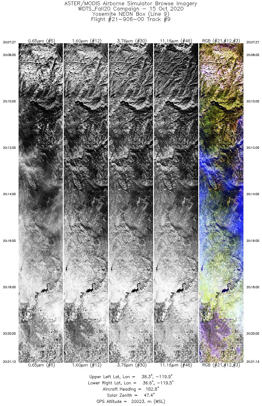
MASTER: Western Diversity Time Series Campaign, WDTS, California, USA, Fall 2020
National Aeronautics and Space Administration —
This dataset includes Level 1B (L1B) and Level 2 (L2) data products from the MODIS/ASTER Airborne Simulator (MASTER) instrument. The spectral data were collected as... -
Federal
MLS/Aura Level 2 Carbon Monoxide (CO) Mixing Ratio V004 (ML2CO) at GES DISC
National Aeronautics and Space Administration —
ML2CO is the EOS Aura Microwave Limb Sounder (MLS) standard product for carbon monoxide derived from radiances measured by the 640 GHz radiometer. The data version is... -
Federal
ECCO Ocean and Sea-Ice Surface Stress - Daily Mean 0.5 Degree (Version 4 Release 4)
National Aeronautics and Space Administration —
This dataset contains daily-averaged ocean and sea-ice surface stress interpolated to a regular 0.5-degree grid from the ECCO Version 4 revision 4 (V4r4) ocean and... -
Federal
ECCO Ocean Bottom Pressure - Daily Mean 0.5 Degree (Version 4 Release 4)
National Aeronautics and Space Administration —
This dataset contains daily-averaged ocean bottom pressure interpolated to a regular 0.5-degree grid from the ECCO Version 4 revision 4 (V4r4) ocean and sea-ice state... -
Federal
CPEX-CV DC-8 Aircraft In-situ Cloud Data
National Aeronautics and Space Administration —
CPEXCV_Cloud_AircraftInSitu_DC8_Data is the in-situ cloud data collected during the Convective Processes Experiment - Cabo Verde (CPEX-CV) onboard the DC-8 aircraft.... -
Federal
Wind SWE Weimer Propagated 60 s Resolution data in GSM Coordinates
National Aeronautics and Space Administration —
Wind SWE propagated solar wind data and linearly interpolated to have the measurements on the minute at 60 s resolution data in GSM coordinates. This data set...

Official websites use .gov
A
.gov website belongs to an official government
organization in the United States.
Secure .gov websites use HTTPS
A
lock (
) or https:// means you’ve safely connected to
the .gov website. Share sensitive information only on official,
secure websites.