
-
Federal
VIIRS/NPP BRDF/Albedo Parameter 1 Band M11 Daily L3 Global 30 ArcSec CMG V002
National Aeronautics and Space Administration —
The NASA/NOAA Suomi National Polar-orbiting Partnership (Suomi NPP) Visible Infrared Imaging Radiometer Suite (VIIRS) Bidirectional Reflectance Distribution Function... -
Federal
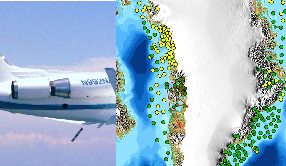
OMG Airborne eXpendable Conductivity Temperature Depth (AXCTD) Profiles
National Aeronautics and Space Administration —
This dataset contains in situ profile measurements from Airborne eXpendable Conductivity Temperature Depth (AXCTD) probes. It provides salinity, density, temperature... -
Federal
M 51 Deep Chandra ACIS X-Ray Point Source Catalog
National Aeronautics and Space Administration —
The authors obtained a deep X-ray image of the nearby galaxy M 51 using the Chandra X-Ray Observatory. Here the catalog of X-ray sources detected in these... -
Federal
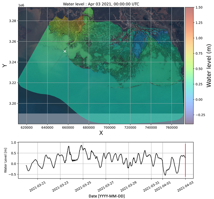
Delta-X: ANUGA Hydrodynamic Outputs, Atchafalaya and Terrebonne, MRD, USA
National Aeronautics and Space Administration —
This dataset comprises the primary inputs and outputs from the ANUGA hydrodynamic model for spring 2021 (2021-03-20 to 2021-04-04). These dates align with the 2021... -
Federal
Ground-Based Global Navigation Satellite System (GNSS)-based Upper Atmospheric Realtime Disaster Information and Alert Network (GUARDIAN) Near Real-Time Ionospheric Total Electron Count (5-second sampling, 24-hour files) from NASA CDDIS
National Aeronautics and Space Administration —
Developed at JPL, GUARDIAN is a near-real-time (NRT) ionospheric monitoring software (Martire et al.). Its main products are NRT total electronic content (TEC) time... -
Federal
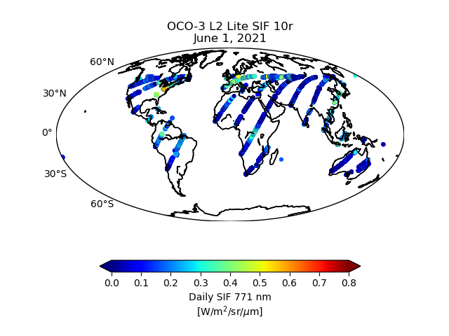
OCO-3 Level 2 bias-corrected solar-induced fluorescence and other select fields from the IMAP-DOAS algorithm aggregated as daily files, Retrospective processing V11r (OCO3_L2_Lite_SIF) at GES DISC
National Aeronautics and Space Administration —
Version 11r is the current version of the data set. Older versions will no longer be available and are superseded by Version 11r. The Orbiting Carbon Observatory -3... -
Federal
OPERA Land Surface Disturbance Annual from Harmonized Landsat Sentinel-2 product (Version 1)
National Aeronautics and Space Administration —
The Observational Products for End-Users from Remote Sensing Analysis (OPERA) Land Surface Disturbance Annual from... -
Federal
VIIRS/NPP DNB BRDF/Albedo Quality Daily L3 Global 1km SIN Grid V002
National Aeronautics and Space Administration —
The NASA/NOAA Suomi National Polar-orbiting Partnership (Suomi NPP) Visible Infrared Imaging Radiometer Suite (VIIRS) Day/Night Band (DNB) Bidirectional Reflectance... -
Federal
SatCORPS CERES GEO Edition 4 Meteosat-09 Northern Hemisphere Version 1.2
National Aeronautics and Space Administration —
CER_GEO_Ed4_MET09_NH_V01.2 is the Satellite Cloud and Radiation Property retrieval System (SatCORPS) Clouds and the Earth's Radiant Energy System (CERES)... -
Federal
ISLSCP II EDGAR 3 Gridded Greenhouse and Ozone Precursor Gas Emissions
National Aeronautics and Space Administration —
The EDGAR (Emission Database for Global Atmospheric Research) database project is a comprehensive task carried out jointly by the National Institute for Public Health... -
Federal
U.S. National Ice Center Arctic and Antarctic Sea Ice Charts in SIGRID-3 Format, Version 1
National Aeronautics and Space Administration —
This data set provides total sea ice concentration, partial concentration, stage of development, and ice form as defined by the World Meteorological Organization in... -
Federal
OMPS-N20 L2 NM Aerosol Index swath orbital NRT
National Aeronautics and Space Administration —
The OMPS-N20 L2 NM Aerosol Index swath orbital V2 for Near Real Time. For the standard product see the OMPS_N20_NMUVAI_L2 product in CMR .The aerosol index is derived... -
Federal
ASTER Level 1 precision terrain corrected registered at-sensor radiance V003
National Aeronautics and Space Administration —
The Terra Advanced Spaceborne Thermal Emission and Reflection Radiometer (ASTER) Level 1 Precision Terrain Corrected Registered At-Sensor Radiance (AST_L1T) data... -
Federal
Lunar Orbiter Laser Altimeter (LOLA) one-way Laser Ranging Full Rate Data (all ranges collected, ground stations, aggregate of normal points daily) from NASA CDDIS
National Aeronautics and Space Administration —
Lunar Orbiter Laser Altimeter (LOLA) one-way laser ranging full rate data. These files contain the full rate data (all ranges collected) as delivered from the ground... -
Federal
MODIS/Terra Ocean Reflectance Daily L2G-Lite Global 1km SIN Grid V006
National Aeronautics and Space Administration —
The MODOCGA Version 6 data product was decommissioned on July 31, 2023. The MODOCGA Version 6 Level 2 Gridded Lite (L2G-lite) Ocean Reflectance product provides an... -
Federal
Southwest Florida optical measurements
National Aeronautics and Space Administration —
Measurements made near southwest Florida in 2010 and 2011. -
Federal
SMAP_L1A_RADAR_RECEIVE_ONLY_METADATA_V002
National Aeronautics and Space Administration —
SMAP Level 1A Radar Receive Only Product Metadata Version 2 -
Federal
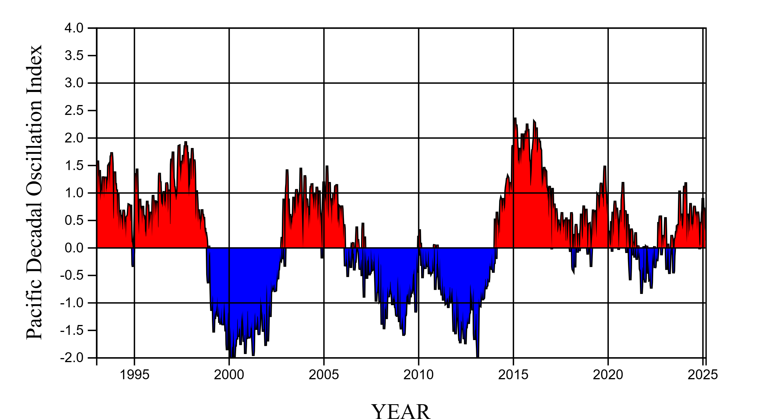
NASA-SSH PDO Sea Surface Height Indicator
National Aeronautics and Space Administration —
This file contains an indicator for the Pacific Decadal Oscillation (PDO), based on satellite observations of sea surface height anomaly, measured by radar altimeter... -
Federal
Hurricane and Severe Storm Sentinel (HS3) Naval Research Laboratory (NRL) Tropics Satellite Data V1
National Aeronautics and Space Administration —
The Hurricane and Severe Storm Sentinel (HS3) Naval Research Laboratory (NRL) Tropics Satellite Data contains browse only data files, including brightness... -
Federal
Landsat-Derived Global Irrigated-Cropland Product L1 2020 30 m V002
National Aeronautics and Space Administration —
The Landsat-Derived Global Irrigated-Cropland Product Level 1 2020 (LGRIP30_L1_IRRI) Version 2 data provides high-resolution, 30 meter (m) cropland data to assist and...

Official websites use .gov
A
.gov website belongs to an official government
organization in the United States.
Secure .gov websites use HTTPS
A
lock (
) or https:// means you’ve safely connected to
the .gov website. Share sensitive information only on official,
secure websites.