
-
Federal
ECCO Ocean Density, Stratification, and Hydrostatic Pressure - Monthly Mean 0.5 Degree (Version 4 Release 4)
National Aeronautics and Space Administration —
This dataset contains monthly-averaged ocean density, stratification, and hydrostatic pressure interpolated to a regular 0.5-degree grid from the ECCO Version 4... -
Federal
ARCSIX P-3B In-Situ Aerosol Data
National Aeronautics and Space Administration —
ARCSIX_Aerosol_AircraftInSitu_P3B_Data is the in-situ aerosol data collected onboard the P-3B aircraft during the Arctic Radiation-Cloud-Aerosol-Surface Interaction... -
Federal
MLS/Aura Level 3 Monthly Binned Nitrous Oxide (N2O) Mixing Ratio on Assorted Grids V005 (ML3MBN2O) at GES DISC
National Aeronautics and Space Administration —
ML3MBN2O is the EOS Aura Microwave Limb Sounder (MLS) monthly binned on various vertical grids product for nitrous oxide (N2O) derived from radiances measured... -
Federal
MODIS/Terra Aerosol Cloud Water Vapor Ozone Monthly L3 Global 1Deg CMG
National Aeronautics and Space Administration —
The MODIS/Terra Aerosol Cloud Water Vapor Ozone Monthly L3 Global 1Deg CMG product (MOD08_M3) contains monthly 1 x 1 degree grid average values of atmospheric... -
Federal
ISLSCP II Global Population of the World
National Aeronautics and Space Administration —
Global Population of the World (GPW) translates census population data to a latitude-longitude grid so that population data may be used in cross-disciplinary studies.... -
Federal
DEVOTE UC-12 Aircraft Research Scanning Polarimeter (RSP) Remotely Sensed Data
National Aeronautics and Space Administration —
DEVOTE_AircraftRemoteSensing_UC12_RSP_Data are remotely sensed data collected via the Research Scanning Polarimeter (RSP) onboard the UC-12 aircraft as part of the... -
Federal
LBA Regional Carbon in Live Vegetation, 0.5-degree (Olson)
National Aeronautics and Space Administration —
This data set is a subset of Olson et al. (1985, 2000) "Major World Ecosystem Complexes Ranked by Carbon in Live Vegetation." This subset was created for the study... -
Federal
STRAT Balloonsondes and Ozonesondes Data
National Aeronautics and Space Administration —
STRAT_Sondes_Data is the balloonsonde and ozonesonde data collected during the Stratospheric Tracers of Atmospheric Transport (STRAT) campaign. Data collection for... -
Federal
SE-590 Lab-Measured Reflectances (OTTER)
National Aeronautics and Space Administration —
Laboratory hemispherical reflectance spectra measurements taken to eliminate the effects of atmosphere, understory, exposed soils, mixed species and canopy architecture. -
Federal
MLS/Aura Level 3 Daily Binned Temperature on Zonal and Similar Grids V005 (ML3DZT) at GES DISC
National Aeronautics and Space Administration —
ML3DZT is the EOS Aura Microwave Limb Sounder (MLS) daily binned on zonal and assorted vertical grids product for temperature derived from radiances measured by the... -
Federal
Bio-optical properties of the different water masses in the Gulf of St. Lawrence
National Aeronautics and Space Administration —
The St. Lawrence ecosystem is a complex environment influenced by a variety of physical forces (runoff, winds, tides, bathymetry) that sustains a diverse food web... -
Federal
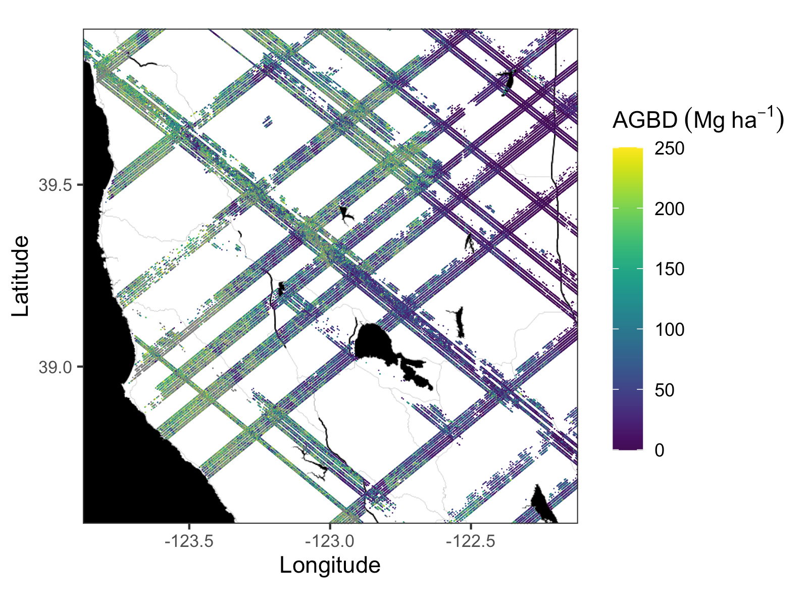
GEDI L4A Footprint Level Aboveground Biomass Density, Golden Weeks, Version 1
National Aeronautics and Space Administration —
This dataset contains Global Ecosystem Dynamics Investigation (GEDI) Level 4A (L4A) predictions of the aboveground biomass density (AGBD; in Mg/ha) and estimates of... -
Federal
Global Navigation Satellite System (GNSS) IGS Final Troposphere Zenith Path Delay (ZPD) Combination Product from NASA CDDIS
National Aeronautics and Space Administration —
This derived product set consists of Global Navigation Satellite System Final Troposphere Zenith Path Delay (ZPD) Product (daily files by station) from the NASA... -
Federal
ATom: Merged Atmospheric Chemistry, Trace Gases, and Aerosols
National Aeronautics and Space Administration —
This dataset provides information on greenhouse gases and human-produced air pollution, including atmospheric concentrations of carbon dioxide (CO2), methane (CH4),... -
Federal
SMEX03 Regional Ground Soil Moisture Data: Oklahoma, Version 1
National Aeronautics and Space Administration —
This data set includes soil moisture measurements for the Oklahoma study region. Summary files containing field averages are also provided. This data set is part of... -
Federal
SMAP_L1A_RADAR_RECEIVE_ONLY_V001
National Aeronautics and Space Administration —
SMAP Level 1A Radar Receive Only Product Version 1 -
Federal
CLPX-Ground: ISA Snow Depth Transects and Related Measurements, Version 2
National Aeronautics and Space Administration —
This data set consists of snow depth data from nine study areas, within three larger-scale areas in northern Colorado (Fraser, North Park, and Rabbit Ears Meso-cell... -
Federal
ASTER L2 Surface Radiance VNIR and Crosstalk Corrected SWIR V004
National Aeronautics and Space Administration —
The Terra Advanced Spaceborne Thermal Emission and Reflection Radiometer (ASTER) Surface Radiance VNIR and Crosstalk Corrected SWIR (AST_09XT) contains... -
Federal
Global Peatland Carbon Balance and Land Use Change CO2 Emissions Through the Holocene
National Aeronautics and Space Administration —
This data set provides a time series of global peatland carbon balance and carbon dioxide emissions from land use change throughout the Holocene (the past 11,000... -
Federal
Earth Radiation Budget through Earth Radiation Budget Satellite Wide-field-of-view Nonscanner Observations Edition
National Aeronautics and Space Administration —
Understanding the mean and variability of the Earth’s radiation budget (ERB) at the Top-of-Atmosphere (TOA) and surface is a fundamental quantity governing climate...

Official websites use .gov
A
.gov website belongs to an official government
organization in the United States.
Secure .gov websites use HTTPS
A
lock (
) or https:// means you’ve safely connected to
the .gov website. Share sensitive information only on official,
secure websites.