
-
Federal
D00239: NOS Hydrographic Survey , 2017-09-15
National Oceanic and Atmospheric Administration, Department of Commerce —
The National Oceanic and Atmospheric Administration (NOAA) has the statutory mandate to collect hydrographic data in support of nautical chart compilation for safe... -
Federal
Continuously Updated Digital Elevation Model (CUDEM) - 1/3 Arc-Second Resolution Bathymetric-Topographic Tiles NGDA
National Oceanic and Atmospheric Administration, Department of Commerce —
NOAA's National Centers for Environmental Information (NCEI) is developing a suite of digital elevation models (DEMs) for the U.S. coast to support a variety of NOAA... -
Federal
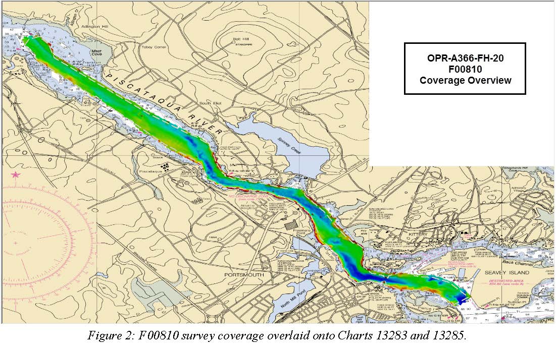
F00810: NOS Hydrographic Survey , 2020-08-05
National Oceanic and Atmospheric Administration, Department of Commerce —
The National Oceanic and Atmospheric Administration (NOAA) has the statutory mandate to collect hydrographic data in support of nautical chart compilation for safe... -
Federal
H07741: NOS Hydrographic Survey , 1949-12-31
National Oceanic and Atmospheric Administration, Department of Commerce —
The National Oceanic and Atmospheric Administration (NOAA) has the statutory mandate to collect hydrographic data in support of nautical chart compilation for safe... -
Federal
H00133A: NOS Hydrographic Survey , 1841-10-19
National Oceanic and Atmospheric Administration, Department of Commerce —
The National Oceanic and Atmospheric Administration (NOAA) has the statutory mandate to collect hydrographic data in support of nautical chart compilation for safe... -
Federal
H06103: NOS Hydrographic Survey , 1936-12-31
National Oceanic and Atmospheric Administration, Department of Commerce —
The National Oceanic and Atmospheric Administration (NOAA) has the statutory mandate to collect hydrographic data in support of nautical chart compilation for safe... -
Federal
H04729: NOS Hydrographic Survey , 1927-12-31
National Oceanic and Atmospheric Administration, Department of Commerce —
The National Oceanic and Atmospheric Administration (NOAA) has the statutory mandate to collect hydrographic data in support of nautical chart compilation for safe... -
Federal
F00036: NOS Hydrographic Survey , 1942-07-12
National Oceanic and Atmospheric Administration, Department of Commerce —
The National Oceanic and Atmospheric Administration (NOAA) has the statutory mandate to collect hydrographic data in support of nautical chart compilation for safe... -
Federal
Multibeam collection for SKQ201701S: Multibeam data collected aboard Sikuliaq from 19-Jan-17 to 15-Feb-17, Manzanillo, Mexico to San Diego, California
National Oceanic and Atmospheric Administration, Department of Commerce —
This data set is part of a larger set of data called the Multibeam Bathymetry Database (MBBDB) where other similar data can be found -
Federal
Multibeam collection for PD20T401: Multibeam data collected aboard Pressure Drop from 20-Aug-20 to 30-Aug-20, None to Honolulu, Hawaii
National Oceanic and Atmospheric Administration, Department of Commerce —
This data set is part of a larger set of data called the Multibeam Bathymetry Database (MBBDB) where other similar data can be found -
Federal
Multibeam collection for SKQ201507T: Multibeam data collected aboard Sikuliaq from 24-Jun-15 to 07-Jul-15, Seward, Alaska to Dutch Harbor, Alaska
National Oceanic and Atmospheric Administration, Department of Commerce —
This data set is part of a larger set of data called the Multibeam Bathymetry Database (MBBDB) where other similar data can be found -
Federal
Multibeam collection for KM1115: Multibeam data collected aboard Kilo Moana from 26-Apr-11 to 14-May-11, Honolulu, Hawaii to Honolulu, Hawaii
National Oceanic and Atmospheric Administration, Department of Commerce —
This data set is part of a larger set of data called the Multibeam Bathymetry Database (MBBDB) where other similar data can be found -
Federal
NCCOS Mapping: Characterizing Submerged Lands Around Naval Base Guam, Mariana Islands, 2016-01-11 to 2022-05-13 (NCEI Accession 0292018)
National Oceanic and Atmospheric Administration, Department of Commerce —
This data package contains information and maps showing the geology and biology of select submerged lands (0 to 50 meters deep) around Navy Base Guam (NBG) and Haputo... -
Federal
U.S. Coastal Relief Model Vol.2 - Southeast Atlantic
National Oceanic and Atmospheric Administration, Department of Commerce —
NGDC's U.S. Coastal Relief Model (CRM) provides the first comprehensive view of the U.S. coastal zone integrating offshore bathymetry with land topography into a... -
Federal
U.S. Coastal Relief Model - Southern California Version 2
National Oceanic and Atmospheric Administration, Department of Commerce —
NGDC's U.S. Coastal Relief Model (CRM) provides a comprehensive view of the U.S. coastal zone integrating offshore bathymetry with land topography into a seamless... -
Federal
Raritan Bay, NJ/NY (M060R) Bathymetric Digital Elevation Model (30 meter resolution) Derived From Source Hydrographic Survey Soundings Collected by NOAA
National Oceanic and Atmospheric Administration, Department of Commerce —
NEW - the following surveys were added because they represent more recent data than those formerly in the same geographic location. They are FE0239 (1979) and H07841... -
Federal
Mariana Trench 6 arc-second Bathymetric Digital Elevation Model
National Oceanic and Atmospheric Administration, Department of Commerce —
NOAA's National Geophysical Data Center (NGDC) created a bathymetric digital elevation model (DEM) for the Mariana Trench and adjacent seafloor in the Western Pacific... -
Federal
Portland, Maine Tsunami Forecast Grids for MOST Model
National Oceanic and Atmospheric Administration, Department of Commerce —
The Portland, Maine Forecast Model Grids provides bathymetric data strictly for tsunami inundation modeling with the Method of Splitting Tsunami (MOST) model. MOST is... -
Federal
Indian River (S190) Bathymetric Digital Elevation Model - NOAA/NOS Estuarine Bathymetry
National Oceanic and Atmospheric Administration, Department of Commerce —
A 1/3 arc-second Mean Lower Low Water bathymetric DEM of NOS hydrographic survey data in Indian River, FL. -
Federal
Atlantic City, New Jersey Coastal Digital Elevation Model
National Oceanic and Atmospheric Administration, Department of Commerce —
NOAA's National Geophysical Data Center (NGDC) is building high-resolution digital elevation models (DEMs) for select U.S. coastal regions. These integrated...

Official websites use .gov
A
.gov website belongs to an official government
organization in the United States.
Secure .gov websites use HTTPS
A
lock (
) or https:// means you’ve safely connected to
the .gov website. Share sensitive information only on official,
secure websites.