
-
Federal
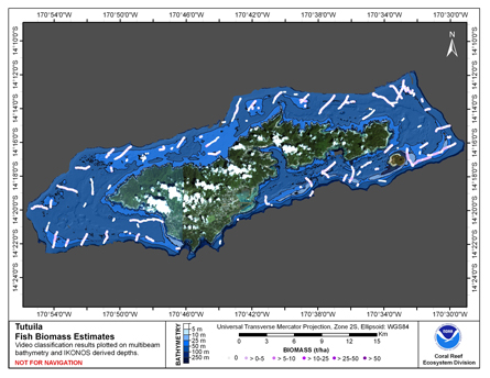
CRED Cumulative Fish Biomass map at Tutuila Island
National Oceanic and Atmospheric Administration, Department of Commerce —
This map displays fish biomass observation locations overlaid on bathymetry. -
Federal
Habitat Zone, Cover and Structure Maps of Rose Atoll 2001-2003, Derived from IKONOS Imagery
National Oceanic and Atmospheric Administration, Department of Commerce —
This project is a cooperative effort between the National Ocean Service, National Centers for Coastal Ocean Science, Center for Coastal Monitoring and Assessment, the... -
Federal
Oahu Hyperspectral Imagery 2000 (210-0612-272217) - Visual Interpretation from Remote Sensing Imagery Main Eight Hawaiian Islands
National Oceanic and Atmospheric Administration, Department of Commerce —
This project is a cooperative effort between the National Ocean Service, National Centers for Coastal Ocean Science, Center for Coastal Monitoring and Assessment, the... -
Federal
Hawaii Hamakua IKONOS and Quickbird Imagery - Mosaic
National Oceanic and Atmospheric Administration, Department of Commerce —
This project is a cooperative effort between the National Ocean Service, National Centers for Coastal Ocean Science, Center for Coastal Monitoring and Assessment, BAE... -
Federal
Map of Percent Scleractinian Coral Cover along towed camera sled tracks and AUV dive tracks over Galvez Bank, Territory of Guam, USA
National Oceanic and Atmospheric Administration, Department of Commerce —
This map displays optical validation observation locations and percent coverage of scleractinian coral overlaid on bathymetry. Optical data were collected by CRED... -
Federal
Shoreline of Kauai Derived From IKONOS and Quick Bird Satellite Imagery, 2004-2006
National Oceanic and Atmospheric Administration, Department of Commerce —
This project is a cooperative effort between the National Ocean Service, National Centers for Coastal Ocean Science, Center for Coastal Monitoring and Assessment, the... -
Federal
West Peninsular Florida 2, 1996 Environmental Sensitivity Index Map
National Oceanic and Atmospheric Administration, Department of Commerce —
Environmental Sensitivity Index (ESI) maps are an integral component in oil-spill contingency planning and assessment. They serve as a source of information in the... -
Federal
Oahu Hyperspectral Imagery 2000 (207b-0613-272217) - Visual Interpretation from Remote Sensing Imagery Main Eight Hawaiian Islands
National Oceanic and Atmospheric Administration, Department of Commerce —
This project is a cooperative effort between the National Ocean Service, National Centers for Coastal Ocean Science, Center for Coastal Monitoring and Assessment, the... -
Federal
Oahu Hyperspectral Imagery 2000 (204b-0613-272217)- Visual Interpretation from Remote Sensing Imagery Main Eight Hawaiian Islands
National Oceanic and Atmospheric Administration, Department of Commerce —
This project is a cooperative effort between the National Ocean Service, National Centers for Coastal Ocean Science, Center for Coastal Monitoring and Assessment, the... -
Federal
Benthic Habitat and Zone Maps of Puerto Rico 1999 - Prepared by Visual Interpretation from Remote Sensing Imagery Collected by NOAA, 1999
National Oceanic and Atmospheric Administration, Department of Commerce —
There are 208 habitat and zone maps of Puerto Rico and is major islands. This project is a cooperative effort between the National Ocean Service, National Centers for... -
Federal
2011 NOAA Ortho-rectified Mosaic of Galveston, Texas (NODC Accession 0105604)
National Oceanic and Atmospheric Administration, Department of Commerce —
This data set contains ortho-rectified mosaic tiles, created as a product from the NOAA Integrated Ocean and Coastal Mapping (IOCM) initiative. The source imagery was... -
Federal
CRED Cumulative Map of Percent Scleractinian Coral Cover along towed camera sled tracks and AUV dive tracks at Rota Island, Commonwealth of the Northern Mariana Islands
National Oceanic and Atmospheric Administration, Department of Commerce —
This map displays optical validation observation locations and percent coverage of scleractinian coral overlaid on bathymetry. Optical data were collected by CRED... -
Federal
CRED Gridded Bathymetry near Northampton Seamounts (100-004), Northwestern Hawaiian Islands
National Oceanic and Atmospheric Administration, Department of Commerce —
File 100-004b is a 60-m ASCII grid of depth data collected near Northampton Seamounts in the Northwestern Hawaiian Islands as of May 2003. This grid has been produced... -
Federal
2006 IKONOS Image Vieques Puerto Rico - opo_215365_000_ps
National Oceanic and Atmospheric Administration, Department of Commerce —
Benthic habitat maps of the nearshore marine environment of Vieques, Puerto Rico were created by visual interpretation of remotely sensed imagery. The objective of... -
Federal
Maui Photomosaic 2000 (312-313-0524) - Orthorectification and Mosaicing of Color Aerial Photography for the Main Eight Hawaiian Islands
National Oceanic and Atmospheric Administration, Department of Commerce —
Habitat maps of the main Hawaiian Islands were created by visual interpretation of aerial photos and hyperspectral imagery using the Habitat Digitizer extension.... -
Federal
CRED Gridded Bathymetry near Northampton Seamounts to West Laysan Island (100-005) Northwestern Hawaiian Islands
National Oceanic and Atmospheric Administration, Department of Commerce —
File 100-005b is a 60-m ASCII grid of depth data collected near Kure Atoll in the Northwestern Hawaiian Islands as of May 2003. This grid has been produced as part of... -
Federal
Hawaii Hyperspectral Imagery 2000 (419-0620-332211) - Visual Interpretation from Remote Sensing Imagery Main Eight Hawaiian Islands
National Oceanic and Atmospheric Administration, Department of Commerce —
This project is a cooperative effort between the National Ocean Service, National Centers for Coastal Ocean Science, Center for Coastal Monitoring and Assessment, the... -
Federal
Benthic Habitats of Puerto Rico and the U.S. Virgin Islands; Photomosaic of Puerto Rico (Isla de Culebra), 1999
National Oceanic and Atmospheric Administration, Department of Commerce —
Habitat maps of Puerto Rico and the U.S. Virgin Islands were created by visual interpretation of aerial photographs using the Habitat Digitizer Extension. Aerial... -
Federal
Habitat Zone, Cover and Structure Maps of the Asuncion Island Northern Mariana Archipelago 2001-2003, Derived From IKONOS Imagery
National Oceanic and Atmospheric Administration, Department of Commerce —
This project is a cooperative effort between the National Ocean Service, National Centers for Coastal Ocean Science, Center for Coastal Monitoring and Assessment, the... -
Federal
ESI-PR41 Naguabo, Puerto Rico 2000 (Environmental Sensitivity Index Map)
National Oceanic and Atmospheric Administration, Department of Commerce —
Environmental Sensitivity Index (ESI) maps are an integral component in oil-spill contingency planning and assessment. They serve as a source of information in the...

Official websites use .gov
A
.gov website belongs to an official government
organization in the United States.
Secure .gov websites use HTTPS
A
lock (
) or https:// means you’ve safely connected to
the .gov website. Share sensitive information only on official,
secure websites.