
-
Federal
Quality Controlled Lightning Imaging Sensor (LIS) on International Space Station (ISS) Backgrounds V2
National Aeronautics and Space Administration —
The Quality Controlled Lightning Imaging Sensor (LIS) on International Space Station (ISS) Backgrounds dataset was collected by the LIS instrument mounted on the ISS... -
Federal
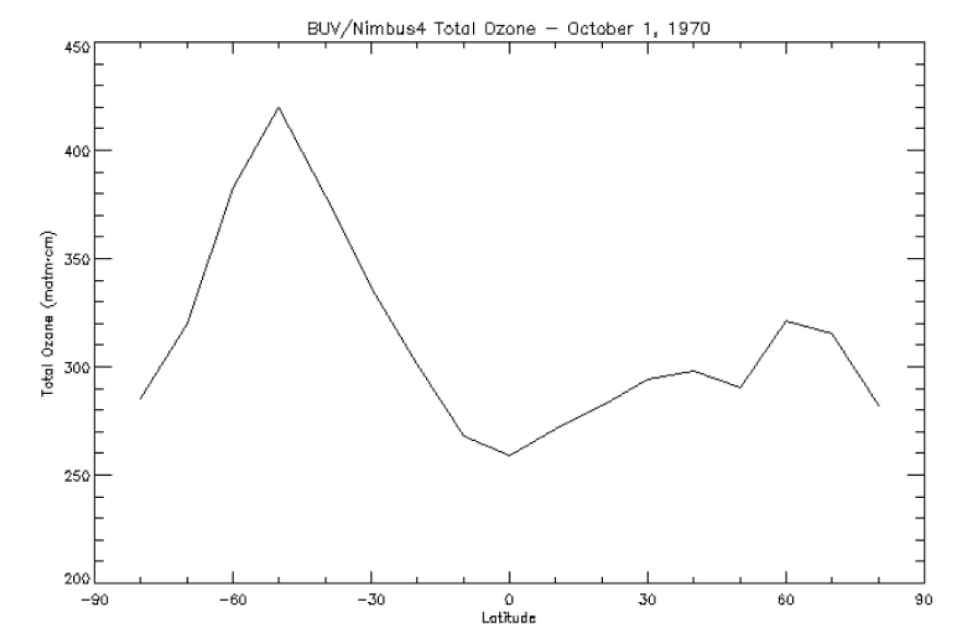
BUV/Nimbus-4 Level 3 Ozone Zonal Means V005 (BUVN4L3ZMT) at GES DISC
National Aeronautics and Space Administration —
The Nimbus-4 BUV Level 3 Ozone Zonal Means collection or ZMT contains total ozone, reflectivities, and ozone mixing ratios averaged in 10 degree latitude zones... -
Federal
ISLSCP II Climate Research Unit CRU05 Monthly Climate Data
National Aeronautics and Space Administration —
This data set contains a mean monthly climatology for several climate variables averaged over the period from 1961 to 1990, and constructed from a data set of station... -
Federal
Integrated Multi-satellitE Retrievals for GPM (IMERG) CPEX V1
National Aeronautics and Space Administration —
The Integrated Multi-satellitE Retrievals for GPM (IMERG) CPEX dataset includes measurements gathered by IMERG during the Convective Processes Experiment (CPEX) field... -
Federal
BOREAS TGB-05 Fire History of Manitoba 1980 to 1991 in Raster Format
National Aeronautics and Space Administration —
This raster format data set covers the province of Manitoba. The data were gridded into the AEAC projection from the original vector data. The original vector data... -
Federal
Combined ASTER and MODIS Emissivity database over Land (CAMEL) Emissivity Monthly Global 0.05Deg V002
National Aeronautics and Space Administration —
The NASA Making Earth System Data Records for Use in Research Environments (MEaSUREs)... -
Federal
Combined ASTER and MODIS Emissivity database over Land (CAMEL) Coefficient Monthly Global 0.05Deg V003
National Aeronautics and Space Administration —
The NASA Making Earth System Data Records for Use in Research Environments (MEaSUREs)... -
Federal
HIRENASD Unstructured Grids - Centaur software
National Aeronautics and Space Administration —
These grids were constructed using Centaur software at DLR in Germany. The grids designed for node based (labeled 'cv') and cell-centered solvers (labeled 'cc') are... -
Federal
Trojan Detection Software Challenge - nlp-sentiment-classification-apr2021-train part2
National Institute of Standards and Technology —
Round 6 Train Dataset part2This is the training data used to construct and evaluate trojan detection software solutions. This data, generated at NIST, consists of... -
Federal
Utah FORGE 3-2417: DAS Microseismic Event Records From Circulation Test - July, 2023
Department of Energy —
This dataset contains distributed acoustic sensing (DAS) microseismic event triggers (waveforms) recorded during the 16A-16B circulation tests conducted at the Utah... -
Federal
Data from: Impacts of gene duplication in the evolution of symbiotic root nodule symbiosis
Department of Agriculture —
The emerging consensus regarding the origin of root nodule symbiosis (RNS), based on modeling of trait gain and loss across approximately 13,000 species within the... -
Federal
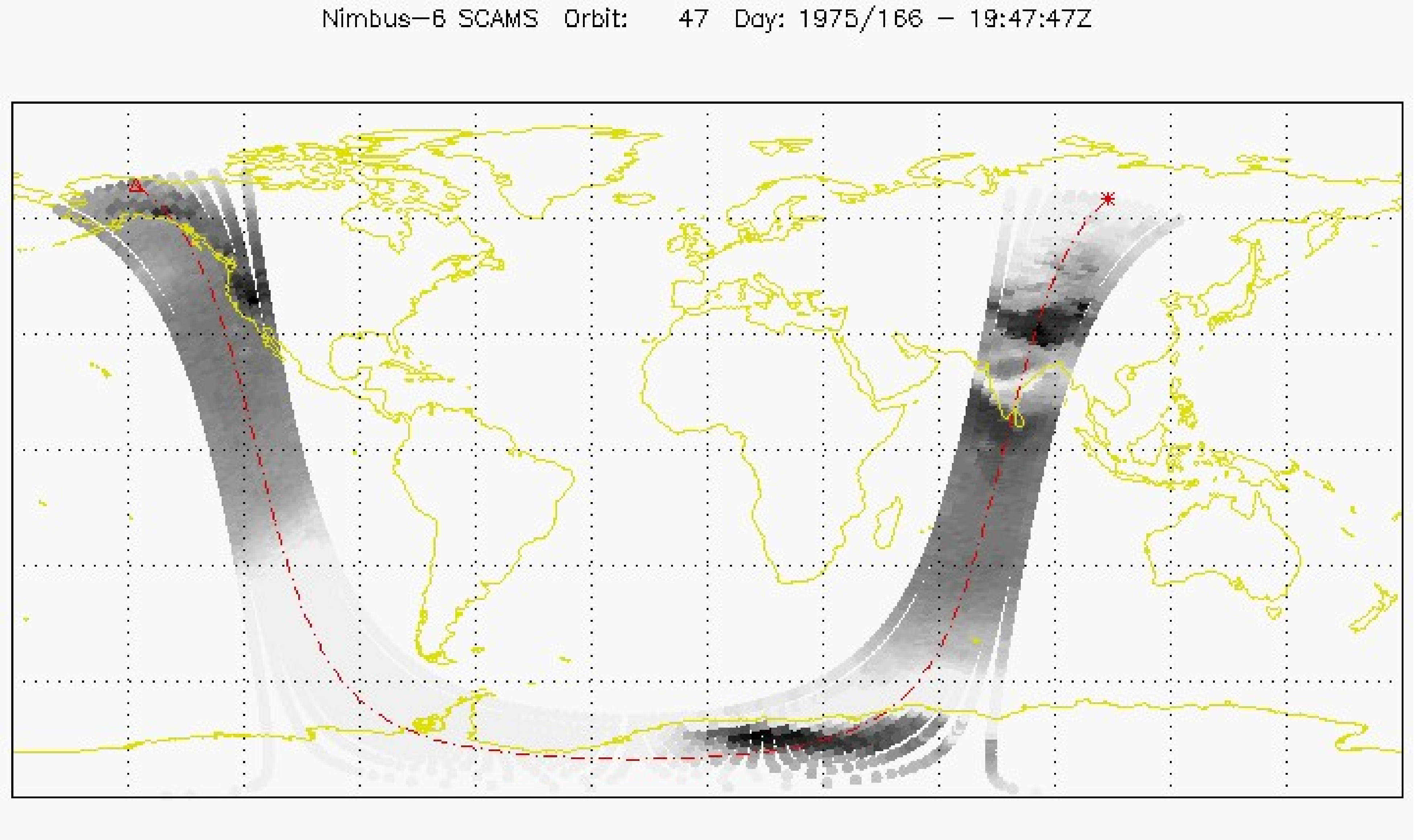
SCAMS/Nimbus-6 Level 2 Water Vapor and Temperature, as well as Antenna and Brightness Temperature V001 (SCAMSN6L2) at GES DISC
National Aeronautics and Space Administration —
The Nimbus-6 Scanning Microwave Spectrometer (SCAMS) Level 2 data product contains water vapor and temperature profiles, as well as antenna and brightness... -
Federal
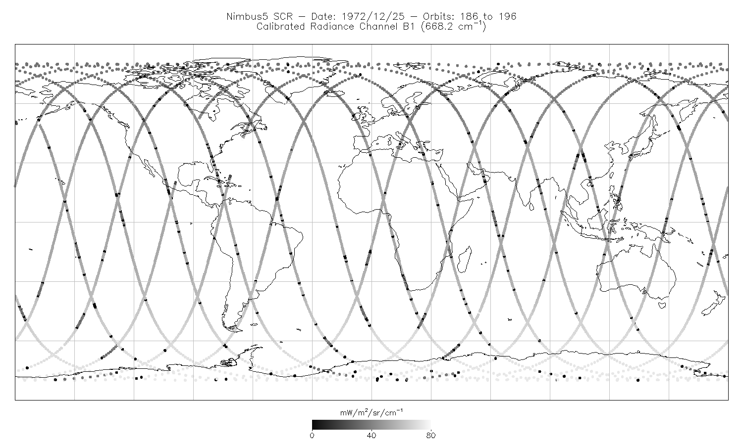
SCR/Nimbus-5 Level 1 Calibrated Radiances V001 (SCRN5L1RAD) at GES DISC
National Aeronautics and Space Administration —
SCRN5L1RAD is the Nimbus-5 Selective Chopper Radiometer (SCR) Level 1 Calibrated Radiances data product. The calibrated radiances are measured at 16 channels from 2.3... -
Federal
SCAMS/Nimbus-6 Images of Brightness Temperatures, Water Vapor and Temperature on 70-mm Film V001 (SCAMSN6IM) at GES DISC
National Aeronautics and Space Administration —
The SCAMSN6IM data product consists of images of brightness temperatures, water vapor and temperature on 70 mm film strips from the Nimbus-6 Scanning Microwave... -
Federal
LRIR/Nimbus-6 Level 2 Inverted Profiles of Temperature and Ozone V001 (LRIRN6L2IPAT) at GES DISC
National Aeronautics and Space Administration —
LRIRN6L2IPAT is the Nimbus-6 Limb Radiance Inversion Radiometer (LRIR) Level 2 Inverted Profiles of Temperature and Ozone data product. The product contains daily... -
Federal
Combined ASTER and MODIS Emissivity database over Land (CAMEL) Uncertainty Monthly Global 0.05Deg V003
National Aeronautics and Space Administration —
The NASA Making Earth System Data Records for Use in Research Environments (MEaSUREs)... -
Federal
Combined ASTER and MODIS Emissivity database over Land (CAMEL) Uncertainty Climatology Monthly Global 0.05Deg V003
National Aeronautics and Space Administration —
The NASA Making Earth System Data Records for Use in Research Environments (MEaSUREs)... -
Federal
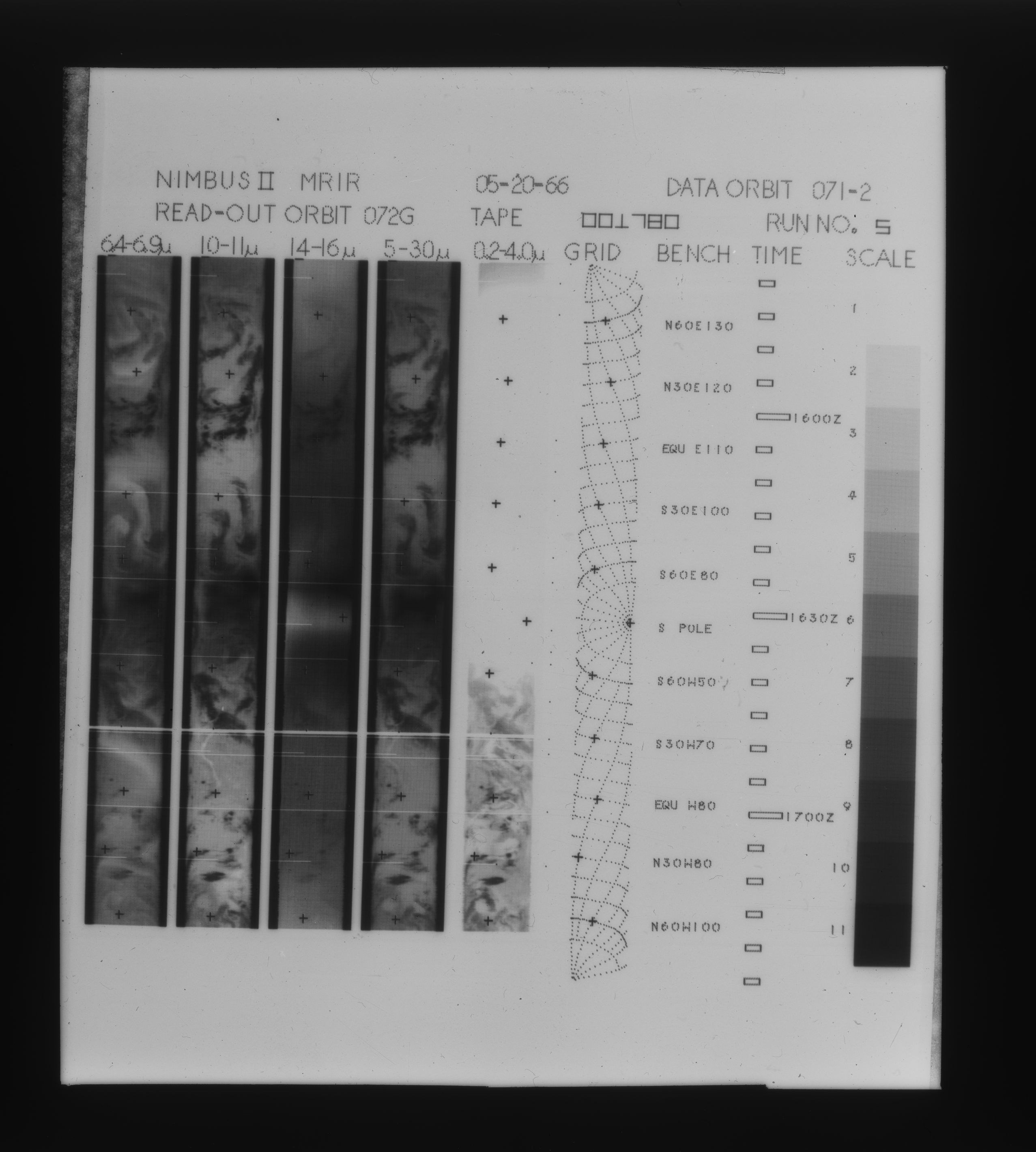
MRIR/Nimbus-3 Images of Daytime Brightness Temperature on 4 x 5 inch Film Sheets V001 (MRIRN3IM) at GES DISC
National Aeronautics and Space Administration —
MRIRN3IM is the Nimbus-3 Medium Resolution Infrared Radiometer (MRIR) data product consisting of 4 x 5 inch photographic film sheets. Each film sheet contains an... -
Federal
MRIR/Nimbus-2 Images of Daytime Brightness Temperature on 4 x 5 inch Film Sheets V001 (MRIRN2IM) at GES DISC
National Aeronautics and Space Administration —
MRIRN2IM is the Nimbus-2 Medium Resolution Infrared Radiometer (MRIR) data product consisting of 4 x 5 inch photographic film sheets. Each film sheet contains an... -
Federal
NASA-SSH Along-Track Sea Surface Height from Standardized Reference Missions Version 1
National Aeronautics and Space Administration —
The NASA-SSH Along-Track Sea Surface Height from Standardized Reference Missions Version 1 dataset produced by NASA provide observations of sea surface height, or sea...

Official websites use .gov
A
.gov website belongs to an official government
organization in the United States.
Secure .gov websites use HTTPS
A
lock (
) or https:// means you’ve safely connected to
the .gov website. Share sensitive information only on official,
secure websites.