
-
Federal
SMEX03 QuikSCAT/SeaWinds Backscatter Data, Oklahoma, Version 1
National Aeronautics and Space Administration —
This data set includes data collected over the Soil Moisture Experiment 2003 (SMEX03) areas of Alabama, Georgia, and Oklahoma, USA. -
Federal
CATS-ISS Level 1B Day Mode 7.2 Version 3-00
National Aeronautics and Space Administration —
CATS-ISS_L1B_D-M7.2-V3-00 is the Cloud-Aerosol Transport System (CATS) International Space Station (ISS) Level 1B Day Mode 7.2 Version 3-00 data product. This... -
Federal
BOREAS TF-11 Decomposition Data over the SSA-Fen
National Aeronautics and Space Administration —
The BOREAS TF-11 team collected several data sets in their efforts to fully describe the flux and site characteristics at the SSA-Fen site. This data set contains... -
Federal
CALIPSO IIR Lidar Level 3 Global Energy and Water Cycle Experiment (GEWEX) Cloud, Standard V1-00
National Aeronautics and Space Administration —
CAL_IIR_L3_GEWEX_Cloud-Standard-V1-00 is the Cloud-Aerosol Lidar and Infrared Pathfinder Satellite Observations (CALIPSO) IIR Level 3 Global Energy and Water Cycle... -
Federal
CAMEX-4 AMPR BRIGHTNESS TEMPERATURE (TB) V1
National Aeronautics and Space Administration —
The CAMEX-4 AMPR Brightness Temperature (TB) dataset was collected by the Advanced Microwave Precipitation Radiometer (AMPR), which was deployed during the Fourth... -
Federal
TROPESS Chemical Reanalysis CH2O Monthly 3-dimensional Product V1 (TRPSCRCH2OM3D) at GES DISC
National Aeronautics and Space Administration —
The TROPESS Chemical Reanalysis CH2O Monthly 3-dimensional Product contains vertical concentrations of formaldehyde. The data are part of the Tropospheric Chemical... -
Federal
Terra MODIS Level-3 Global Binned 4µm Nighttime Sea Surface Temperature (SST4) Data, version R2019.0
National Aeronautics and Space Administration —
MODIS (or Moderate-Resolution Imaging Spectroradiometer) is a key instrument aboard the Terra (EOS AM) and Aqua (EOS PM) satellites. Terra's orbit around the Earth is... -
Federal
Terra MODIS Level-3 Global Mapped 4µm Nighttime Sea Surface Temperature (SST4) Data, version R2019.0
National Aeronautics and Space Administration —
MODIS (or Moderate-Resolution Imaging Spectroradiometer) is a key instrument aboard the Terra (EOS AM) and Aqua (EOS PM) satellites. Terra's orbit around the Earth is... -
Federal
Suomi-NPP VIIRS Level-2 Regional Triple-window Sea Surface Temperature (SST3) Data, version R2016.2
National Aeronautics and Space Administration —
The Visible and Infrared Imager/Radiometer Suite (VIIRS) is a multi-disciplinary instrument that is being flown on the Joint Polar Satellite System (JPSS) series of... -
Federal
STS-68_METADATA_GRD
National Aeronautics and Space Administration —
Metadata for STS-68 SIR-C Ground Range Product -
Federal
Suomi-NPP VIIRS Level-3 Global Mapped Triple-window Sea Surface Temperature (SST3) Data, version R2016.2
National Aeronautics and Space Administration —
The Visible and Infrared Imager/Radiometer Suite (VIIRS) is a multi-disciplinary instrument that is being flown on the Joint Polar Satellite System (JPSS) series of... -
Federal
Global Navigation Satellite Systems (GNSS) Real-Time Orbit Products from NASA CDDIS
National Aeronautics and Space Administration —
Precise satellite orbits derived from analysis of Global Navigation Satellite System (GNSS) data. Analysis Centers (ACs) of the International GNSS Service (IGS)... -
Federal
Ground-Based Global Navigation Satellite System (GNSS) GLONASS real-time POD Clock Corrections (1-second sampling, 60-second files) from NASA CDDIS
National Aeronautics and Space Administration —
This product contains a high-rate time series of clock biases for healthy satellites in the GLONASS constellation that are accumulated every minute throughout the... -
Federal
Ground-Based Global Navigation Satellite System (GNSS) GPS real-time POD Orbits (60-second sampling, 60-second files) from NASA CDDIS
National Aeronautics and Space Administration —
This product contains a time series of position and velocity components for healthy satellites in the GPS constellation that are accumulated every minute throughout... -
Federal
TROPICS03 L2B Deep Multispectral INtensity (DMIN) of Tropical cyclones estimator Algorithm V1.0
National Aeronautics and Space Administration —
The "Time-Resolved Observations of Precipitation structure and storm Intensity with a Constellation of Smallsats" (TROPICS) mission has a goal of providing nearly... -
Federal
TROPESS Chemical Reanalysis SO2 Monthly 3-dimensional Product V1 (TRPSCRSO2M3D) at GES DISC
National Aeronautics and Space Administration —
The TROPESS Chemical Reanalysis SO2 Monthly 3-dimensional Product contains vertical concentrations of sulfur dioxide. The data are part of the Tropospheric Chemical... -
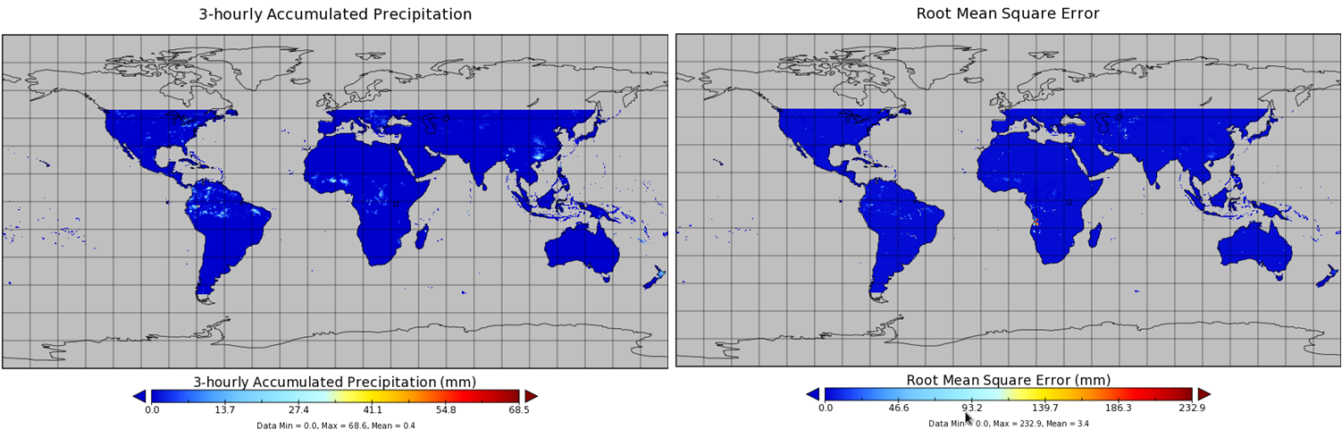
Federal
TMI/TRMM precipitation and uncertainty (TMPA) L3 3 hour 0.25 degree x 0.25 degree V001 (WC_MULTISEN_PREC_025) at GES DISC
National Aeronautics and Space Administration —
TMI/TRMM precipitation and uncertainty (TMPA) L3 3 hour 0.25 degree x 0.25 degree V001 provides estimates of accumulated precipitation from the Tropical Rainfall... -
Federal
Global Navigation Satellite System (GNSS) Rapid Clocks Products from NASA CDDIS
National Aeronautics and Space Administration —
Satellite and receiver clock products derived from analysis of Global Navigation Satellite System (GNSS) data. These products are the generated by analysis centers in... -
Federal
Global Navigation Satellite System (GNSS) Earth Rotation Parameters (ERP) products from NASA CDDIS
National Aeronautics and Space Administration —
Earth Rotation Parameters (ERPs) derived from analysis of Global Navigation Satellite System (GNSS) data. These products are the generated by analysis centers in... -
Federal
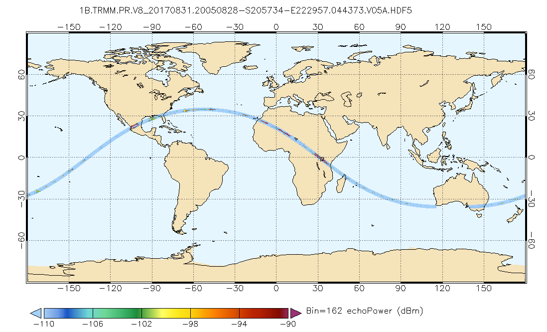
GPM PR on TRMM Echo Power L1B 1.5 hours 5 km V07 (GPM_1BPR) at GES DISC
National Aeronautics and Space Administration —
This is the new (GPM-formated) TRMM product. It replaces the old TRMM_1B21,1C21 Version 07 is the current version of the data set. Previous versions have been...

Official websites use .gov
A
.gov website belongs to an official government
organization in the United States.
Secure .gov websites use HTTPS
A
lock (
) or https:// means you’ve safely connected to
the .gov website. Share sensitive information only on official,
secure websites.