
-
Federal
SWOT Level 2 KaRIn Low Rate Sea Surface Height Data Product - Unsmoothed, Version D
National Aeronautics and Space Administration —
The SWOT Level 2 KaRIn Low Rate Sea Surface Height Unsmoothed Data Product from the Surface Water Ocean Topography (SWOT) mission provides global sea surface height... -
Federal
VIIRS/NOAA20 Deep Blue Level 3 daily aerosol data, 1 degree x 1 degree grid
National Aeronautics and Space Administration —
The VIIRS/NOAA20 Deep Blue Level 3 daily aerosol data, 1x1 degree grid, Short-name AERDB_D3_VIIRS_NOAA20 product is derived from the Version-2.0 (V2.0) L2 6-minute... -
Federal
Radarsat Antarctic Mapping Project Digital Elevation Model, Version 2
National Aeronautics and Space Administration —
The high-resolution Radarsat Antarctic Mapping Project (RAMP) Digital Elevation Model (DEM) combines topographic data from a variety of sources to provide consistent... -
Federal
TOPEX/POSEIDON Geophysical Data Record Version F
National Aeronautics and Space Administration —
The TOPEX/POSEIDON Geophysical Data Record (GDR) contains global coverage altimeter data. The objective of the TOPEX/POSEIDON mission, launched in August 1992, is to... -
Federal
Ulysses Heliosphere Instrument for Spectral, Composition, and Anisotropy at Low Energies (HISCALE) LEFS60 Count Rates, 11.5 s Averages
National Aeronautics and Space Administration —
12sec-averaged sectored count rates from LEFS60. The HISCALE instrument contains the Low-Energy Magnetic Spectrometers (LEMS), the Low-Energy Foil Spectrometers... -
Federal
S-MODE MASS Level 1 Lidar Point Cloud Version 1
National Aeronautics and Space Administration —
This dataset contains geolocated airborne LiDAR point cloud measurements from the Sub-Mesoscale Ocean Dynamics Experiment (S-MODE) conducted approximately 300 km... -
Federal
PEM Tropics B P-3B In-Situ Aerosol Data
National Aeronautics and Space Administration —
PEM-Tropics-B_Aerosol_AircraftInSitu_P3B_Data is the in-situ aerosol data collected onboard the P-3B aircraft during the Pacific Exploratory Mission (PEM) Tropics B... -
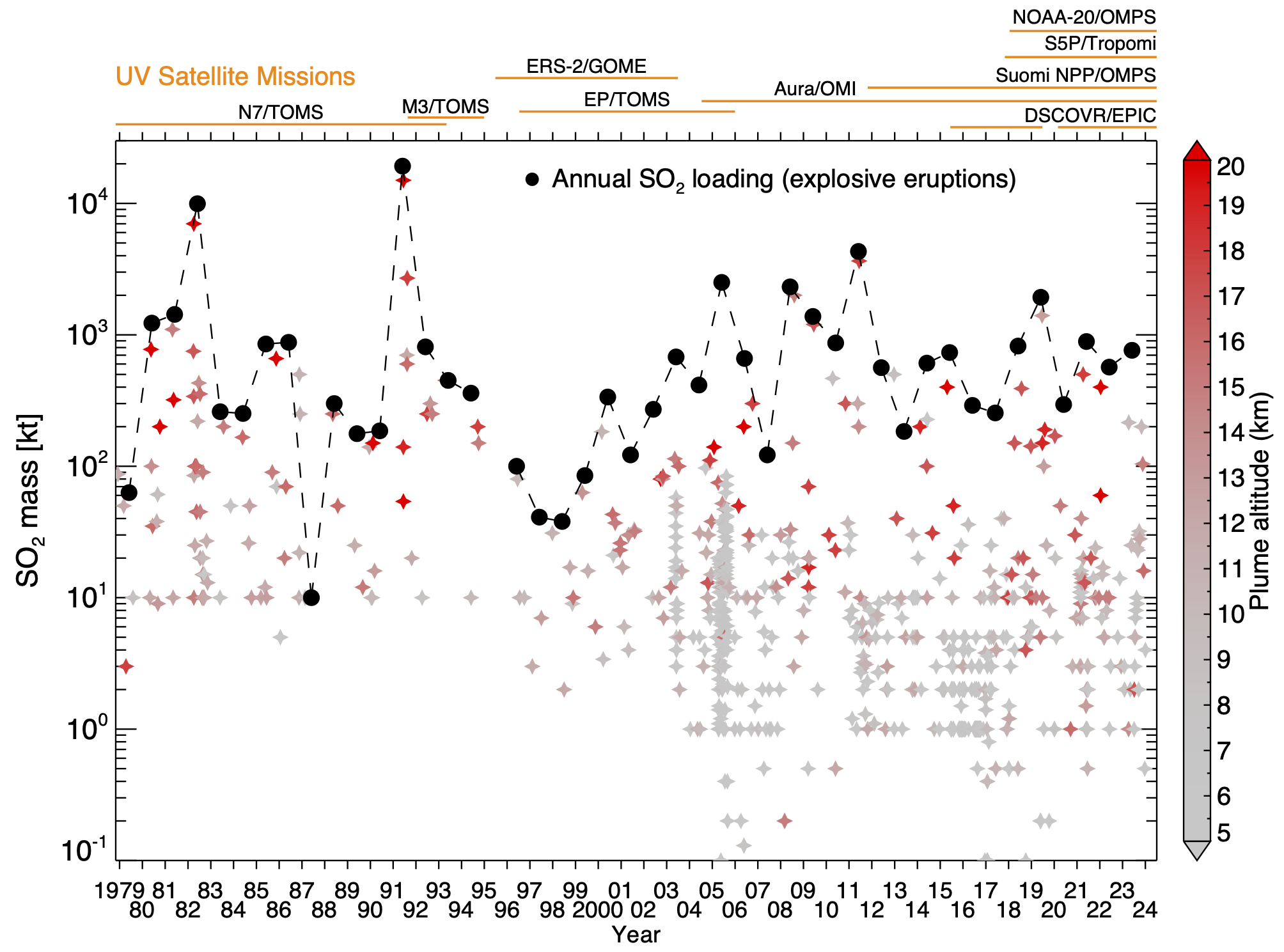
Federal
Multi-Satellite Volcanic Sulfur Dioxide L4 Long-Term Global Database V4 (MSVOLSO2L4) at GES DISC
National Aeronautics and Space Administration —
Version 4 is the current version of the data set. Older versions are no longer available and have been superseded by Version 4. These data are a part of MEaSUREs 2012... -
Federal
NAAMES R/V Atlantis Aerosol In Situ Data, Version 1
National Aeronautics and Space Administration —
NAAMES_Aerosol_ShipInSitu_Data are in situ aerosol measurements collected onboard the R/V Atlantis vessel during the North Atlantic Aerosols and Marine Ecosystems... -
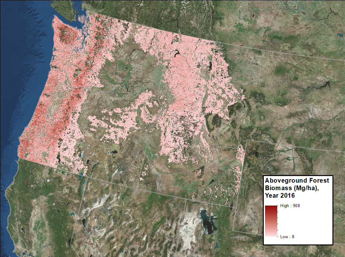
Federal
Annual Aboveground Biomass Maps for Forests in the Northwestern USA, 2000-2016
National Aeronautics and Space Administration —
This dataset provides annual maps of aboveground biomass (AGB, Mg/ha) for forests in Washington, Oregon, Idaho, and western Montana, USA, for the years 2000-2016, at... -
Federal
GEDI L4A Footprint Level Aboveground Biomass Density, Version 1
National Aeronautics and Space Administration —
This dataset contains Global Ecosystem Dynamics Investigation (GEDI) Level 4A (L4A) predictions of the aboveground biomass density (AGBD; in Mg/ha) and estimates of... -
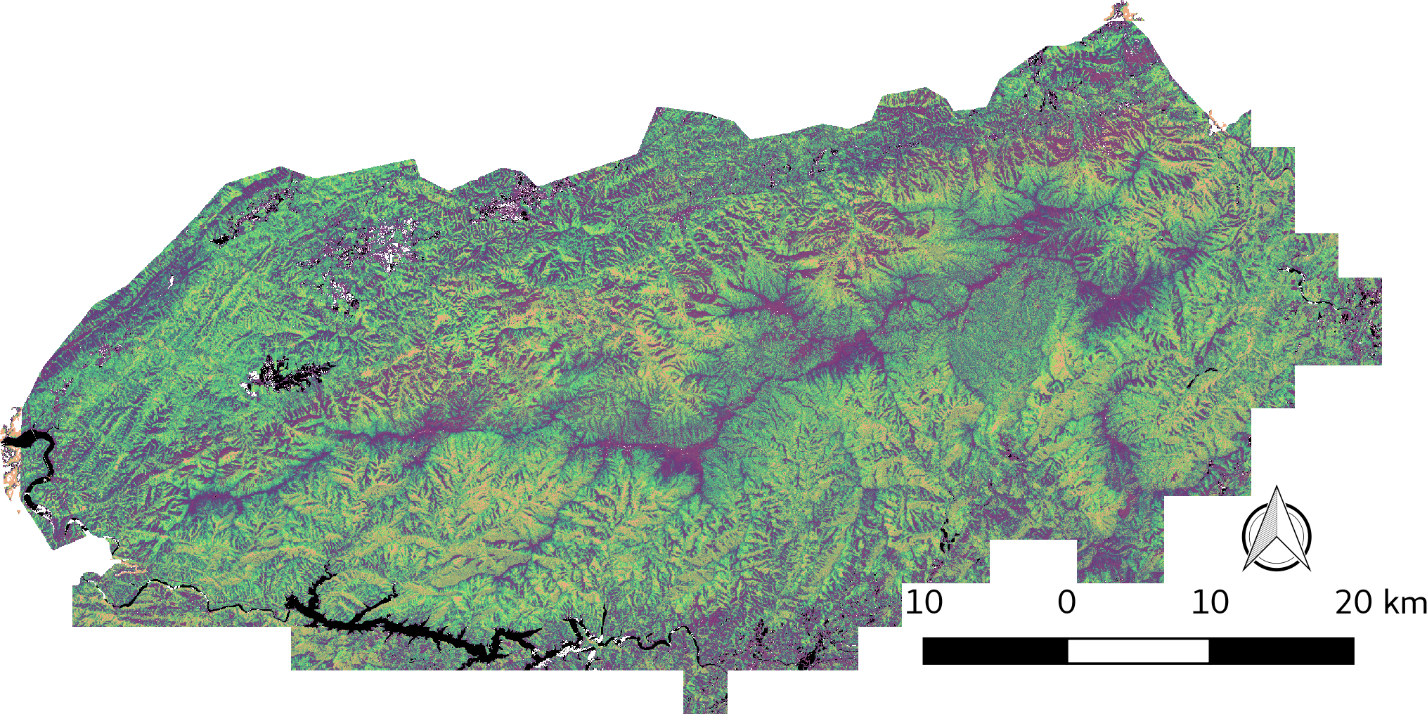
Federal
LiDAR-derived Vegetation Canopy Structure, Great Smoky Mountains National Park, 2011
National Aeronautics and Space Administration —
This dataset provides multiple-return LiDAR-derived vegetation canopy structure at 30-meter spatial resolution for the Great Smoky Mountains National Park (GSMNP).... -
Federal
GHRSST Level 2P Global Sea Surface Temperature v2.0 from the AVHRR on the MetOp-B satellite produced by NAVO
National Aeronautics and Space Administration —
A global Group for High Resolution Sea Surface Temperature (GHRSST) Level 2P data set containing multi-channel Sea Surface Temperature (SST) retrievals derived in... -
Federal
CERES Regionally Averaged Computed TOA, within the Atmosphere, and Surface Fluxes Hourly Terra Edition4A
National Aeronautics and Space Administration —
CER_CRS1deg-Hour_Terra-MODIS_Edition4A is the Terra Clouds and the Earth's Radiant Energy System (CERES) Level 3 computed flux Edition4A data product. The Cloud and... -
Federal
LBA-ECO TG-05 NPP, Carbon Pool, Soil Characteristics, Soil Gas Flux Maps of Brazil
National Aeronautics and Space Administration —
This data set provides maps produced from model output data from the National Aeronautics and Space Administration-Carnegie Ames Stanford Approach (NASA-CASA) model... -
Federal
CATS-ISS Level 1B Day Mode 7.1 Version 3-00
National Aeronautics and Space Administration —
CATS-ISS_L1B_D-M7.1-V3-00 is the Cloud-Aerosol Transport System (CATS) International Space Station (ISS) Level 1B Day Mode 7.1 Version 3-00 data product. The... -
Federal
DISCOVER-AQ Texas Deployment P-3B Aircraft In Situ Aerosol Data
National Aeronautics and Space Administration —
DISCOVERAQ_Texas_Aerosol_AircraftInSitu_P3B_Data contains in situ aerosol data collected onboard NASA's P-3B aircraft during the Texas (Houston) deployment of NASA's... -
Federal
Global Landslide Nowcast from LHASA L4 1 day 1 km x 1 km version 2.0.0 (Global_Landslide_Nowcast) at GES DISC
National Aeronautics and Space Administration —
The Global Landslide Nowcast addresses the need for real-time situational awareness of landslide hazard. The Landslide Hazard Assessment for Situational Awareness... -
Federal
CERES and GEO-Enhanced TOA, Within-Atmosphere and Surface Fluxes, Clouds and Aerosols 1-Hourly Terra Edition4A
National Aeronautics and Space Administration —
CER_SYN1deg-1Hour_Terra-MODIS_Edition4A is the Clouds and the Earth's Radiant Energy System (CERES) and geostationary (GEO)-Enhanced Top-of-Atmosphere (TOA), Within-...

Official websites use .gov
A
.gov website belongs to an official government
organization in the United States.
Secure .gov websites use HTTPS
A
lock (
) or https:// means you’ve safely connected to
the .gov website. Share sensitive information only on official,
secure websites.