
-
Federal
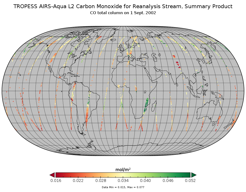
TROPESS AIRS-Aqua L2 Carbon Monoxide for Reanalysis Stream, Summary Product V1 (TRPSYL2COAIRSORS) at GES DISC
National Aeronautics and Space Administration —
The TROPESS AIRS-Aqua L2 Carbon Monoxide for Reanalysis Stream, Summary Product contains the vertical distribution of the retrieved atmospheric state of carbon... -
Federal
VIIRS/JPSS1 BRDF/Albedo Uncertainty Daily L3 Global 30ArcSec CMG V002
National Aeronautics and Space Administration —
The NOAA-20 Visible Infrared Imaging Radiometer Suite (VIIRS) Bidirectional Reflectance Distribution Function (BRDF) and Albedo Uncertainty product (VJ143D53) is... -
Federal
ROSETTA-ORBITER 67P OSIWAC 4 PRL-MTP009 RDR-STR-REFL V1.0
National Aeronautics and Space Administration —
This CODMAC level 4 data set contains solar stray light corrected, radiometric calibrated and geometric distortion corrected (resampled) image data in in reflectance... -
Federal
PEM West A Ground Data
National Aeronautics and Space Administration —
PEM-West-A_Ground_Data is the ground site data collected during the Pacific Exploratory Mission (PEM) West A suborbital campaign. Data utilizing the Nondispersive... -
Federal
SatCORPS CERES GEO Edition 4 GOES-16 Southern Hemisphere Version 1.4
National Aeronautics and Space Administration —
CER_GEO_Ed4_GOE16_SH_V01.4 is the Satellite Cloud and Radiation Property retrieval System (SatCORPS) Clouds and the Earth's Radiant Energy System (CERES)... -
Federal
CAMEX-4 ER-2 NAVIGATION DATA V1
National Aeronautics and Space Administration —
The CAMEX-4 ER-2 Navigation data files contain information recorded by on board navigation and data collection systems. In addition to typical navigation data (e.g.... -
Federal
VIIRS/JPSS1 BRDF/Albedo BSA at Solar Noon ShortWave Daily L3 Global 30ArcSec CMG V002
National Aeronautics and Space Administration —
The NOAA-20 Visible Infrared Imaging Radiometer Suite (VIIRS) Bidirectional Reflectance Distribution Function (BRDF) and Albedo Black-Sky Albedo for ShortWave... -
Federal
ECCO Sea-Ice Velocity - Daily Mean llc90 Grid (Version 4 Release 4)
National Aeronautics and Space Administration —
This dataset provides daily-averaged sea-ice velocity on the native Lat-Lon-Cap 90 (LLC90) model grid from the ECCO Version 4 Release 4 (V4r4) ocean and sea-ice state... -
Federal
ABoVE: Seasonal Dissolved Gases and Isotopes in Arctic Alaska Rivers
National Aeronautics and Space Administration —
This dataset provides dissolved carbon dioxide (CO2) and methane (CH4) concentrations alongside their stable and radiocarbon isotopic compositions within the Arctic... -
Federal
SBUV2/NOAA-9 Ozone (O3) Profile and Total Column Ozone 1 Month Zonal Mean L3 Global 5.0 degree Latitude Zones V1 (SBUV2N09L3zm) at GES DISC
National Aeronautics and Space Administration —
The Solar Backscattered Ultraviolet (SBUV) from NOAA-9 Level-3 monthly zonal mean (MZM) product (SBUV2N17L3zm) is derived from the Level-2 retrieved ozone profiles.... -
Federal
TROPICS05 L2A Unified Resolution Brightness Temperatures V0.2
National Aeronautics and Space Administration —
The "Time-Resolved Observations of Precipitation structure and storm Intensity with a Constellation of Smallsats" (TROPICS) mission has a goal of providing nearly... -
Federal
SENTINEL-1A_SINGLE_POL_GRD_FULL_RES
National Aeronautics and Space Administration —
Sentinel-1A Single-pol ground range detected full resolution images -
Federal
VIIRS/JPSS2 Day/Night Band 6-Min L1B Swath SDR 750m NRT
National Aeronautics and Space Administration —
The Near Real Time (NRT) VIIRS Level 1 and Level 2 swath (VJ202DNB_NRT) product is single NASA VIIRS panchromatic Day-Night band (DNB) calibrated radiance product.... -
Federal
NCA-LDAS Noah-3.3 Land Surface Model L4 Trends 0.125 x 0.125 degree V2.0 (NCALDAS_NOAH0125_Trends) at GES DISC
National Aeronautics and Space Administration —
The National Climate Assessment - Land Data Assimilation System, or NCA-LDAS, is a terrestrial water reanalysis in support of the United States Global Change Research... -
Federal
Alpha Jet Atmospheric eXperiment Formaldehyde Data
National Aeronautics and Space Administration —
The Alpha Jet Atmospheric eXperiment (AJAX) is a partnership between NASA's Ames Research Center and H211, L.L.C., facilitating routine in-situ measurements over... -
Federal
TROPESS CrIS-SNPP L2 for Los Angeles Megacity, Standard Product V1 (TRPSDL2ALLCRSMGLOS) at GES DISC
National Aeronautics and Space Administration —
The TROPESS CrIS-SNPP L2 for Los Angeles Megacity, Standard Product contains the vertical distribution of seven retrieved atmospheric gases (CH4, CO, H2O, HDO, NH3,... -
Federal
AirMOSS: L2/3 Volumetric Soil Moisture Profiles Derived From Radar, 2012-2015
National Aeronautics and Space Administration —
This data set provides level 2/3 root zone soil moisture (RZSM) estimates at multiple depths at 90-m spatial resolution from the Airborne Microwave Observatory of... -
Federal
BOREAS TE-23 Map Plot Data
National Aeronautics and Space Administration —
The BOREAS TE-23 team collected map plot data in support of its efforts to characterize and interpret information on canopy architecture and understory cover at the... -
Federal
Combined ASTER and MODIS Emissivity database over Land (CAMEL) Covariances Climatology Monthly Global 0.25Deg V003
National Aeronautics and Space Administration —
The NASA Making Earth System Data Records for Use in Research Environments (MEaSUREs)...

Official websites use .gov
A
.gov website belongs to an official government
organization in the United States.
Secure .gov websites use HTTPS
A
lock (
) or https:// means you’ve safely connected to
the .gov website. Share sensitive information only on official,
secure websites.