
-
Federal
LMOS Miscellaneous and Ancillary Data Products
National Aeronautics and Space Administration —
LMOS_Miscellaneous_Data is the supplementary and ancillary data to support the Lake Michigan Ozone Study (LMOS). This data product currently features supplementary... -
Federal
Soil CH4 and CO2 Profile Data from NSA Tower Sites
National Aeronautics and Space Administration —
The BOREAS TGB-01 team made numerous measurements of trace gas concentrations and fluxes at various NSA sites. This data set contains methane (CH4) and carbon dioxide... -
Federal
CERES and GEO-Enhanced TOA, Within-Atmosphere and Surface Fluxes, Clouds and Aerosols 3-Hourly Terra Edition4A
National Aeronautics and Space Administration —
CER_SYN1deg-3Hour_Terra-MODIS_Edition4A is the Clouds and the Earth's Radiant Energy System (CERES) and geostationary (GEO)-Enhanced Top of Atmosphere (TOA), Within-... -
Federal
LIS/OTD 2.5 Degree Low Resolution Time Series (LRTS) V2.3.2015
National Aeronautics and Space Administration —
The LIS/OTD 2.5 Degree Low Resolution Time Series (LRTS) contains a variety of gridded climatologies of total lightning flash rates obtained from two lightning... -
Federal
MODIS/Aqua Thermal Anomalies/Fire 8-Day L3 Global 1km SIN Grid V006
National Aeronautics and Space Administration —
The MYD14A2 Version 6 data product was decommissioned on July 31, 2023. Users are encouraged to use the MYD14A2... -
Federal
Deep Space Climate Observatory National Institute of Standards and Technology Advanced Radiometer Level 1B Radiance, Version 3
National Aeronautics and Space Administration —
DSCOVR_NISTAR_L1B_3 is the Deep Space Climate Observatory (DSCOVR) National Institute of Standards & Technology Advanced Radiometer (NISTAR) Level 1B version 3... -
Federal
LMOS Schiller Park Ground Site Data
National Aeronautics and Space Administration —
LMOS_Ground_SchillerPark_Data_1 is the Lake Michigan Ozone Study (LMOS) data collected at the Schiller Park ground site during the LMOS field campaign. This product... -
Federal
GPM DPR and GMI (Combined Precipitation) L3 1 month 0.25 degree x 0.25 degree V07 (GPM_3CMB) at GES DISC
National Aeronautics and Space Administration —
Version 07 is the current version of the data set. Older versions will no longer be available and have been superseded by Version 07. This is a precipitation product... -
Federal
NPP Multi-Biome: NPP and Driver Data for Ecosystem Model-data Intercomparison, R2
National Aeronautics and Space Administration —
This data set represents a refined set of global net primary productivity (NPP) estimates and model driver data that are the results of the Ecosystem Model-Data... -
Federal
Reduced-Resolution QuickBird Imagery and Related GIS Layers for Barrow, Alaska, USA, Version 1
National Aeronautics and Space Administration —
This data set contains reduced-resolution QuickBird imagery and geospatial data for the entire Barrow QuickBird image area 156.15° W - 157.07° W, 71.15° N - 71.41° N)... -
Federal
CERES and GEO-Enhanced TOA, Within-Atmosphere and Surface Fluxes, Clouds and Aerosols Monthly Terra-Aqua-NOAA20 Edition4B
National Aeronautics and Space Administration —
CER_SYN1deg-Month_Terra-Aqua-NOAA20_Edition4B is the Clouds and the Earth's Radiant Energy System (CERES) and geostationary (GEO)-Enhanced Top of Atmosphere (TOA),... -
Federal
GLM Events and Flashes Data
National Aeronautics and Space Administration —
The GLM Events and Flashes Data consist of the size and number of lightning flashes and events. The data were collected from the Geostationary Lightning Mapper (GLM)... -
Federal
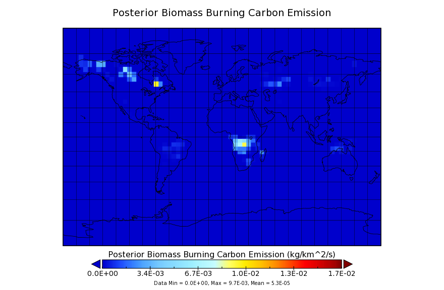
Carbon Monitoring System Flux for Posterior Fire Carbon L4 V1 (CMSFluxFirepost) at GES DISC
National Aeronautics and Space Administration —
This dataset provides the Carbon Flux for Fires. The NASA Carbon Monitoring System (CMS) is designed to make significant contributions in characterizing, quantifying,... -
Federal
Antarctic Marine Living Resources (AMLR) program
National Aeronautics and Space Administration —
Measurements taken under the U.S. Antarctic Marine Living Resources (AMLR) program spanning 1997 to 2008. -
Federal
VIIRS/NPP Land Surface Temperature and Emissivity 6-Min L2 Swath 750m V001
National Aeronautics and Space Administration —
The VNP21 VIIRS Version 1 data product was decommissioned on April 8th, 2025. Users are encouraged to use Version 2 data products, which provideFederalMODIS/Terra Land Surface Temperature/3-Band Emissivity 5-Min L2 1km V006
National Aeronautics and Space Administration —
The MOD21 Version 6 data product was decommissioned on July 31, 2023. Users are encouraged to use the MOD21 Version...FederalMODIS/Aqua Vegetation Indices 16-Day L3 Global 0.05Deg CMG V061
National Aeronautics and Space Administration —
The Aqua Moderate Resolution Imaging Spectroradiometer (MODIS) Vegetation Indices 16-Day (MYD13C1) Version 6.1 product provides a Vegetation Index (VI) value at a per...FederalATMOS L1 Spectra and Runlogs V3 (ATMOSL1) at GES DISC
National Aeronautics and Space Administration —
This is the version 3 Atmospheric Trace Molecule Spectroscopy (ATMOS) Level 1 product containing spectra and runlog (i.e. ) information in a netCDF format. ATMOS is...FederalLBA Regional Historical Croplands, 5-min, 1900-1992 (Ramankutty and Foley)
National Aeronautics and Space Administration —
This data set is a subset of a global croplands data set (Ramankutty and Foley 1999a). The subset was created for the study area of the Large Scale Biosphere-...9,607 datasets found

Official websites use .gov
A
.gov website belongs to an official government
organization in the United States.
Secure .gov websites use HTTPS
A
lock (
) or https:// means you’ve safely connected to
the .gov website. Share sensitive information only on official,
secure websites.