
-
Federal
First ISCCP Regional Experiment (FIRE) Atlantic Stratocumulus Transition Experiment (ASTEX) NASA ER-2 Cloud Lidar System Data
National Aeronautics and Space Administration —
The First ISCCP Regional Experiments have been designed to improve data products and cloud/radiation parameterizations used in general circulation models (GCMs).... -
Federal
ECCO Sea-Ice and Snow Concentration and Thickness - Daily Mean llc90 Grid (Version 4 Release 4)
National Aeronautics and Space Administration —
This dataset provides daily-averaged sea-ice and snow concentration, thickness, and pressure loading on the native Lat-Lon-Cap 90 (LLC90) model grid from the ECCO... -
Federal
GHRSST Level 3U NOAA STAR SST v2.80 from VIIRS on S-NPP Satellite
National Aeronautics and Space Administration —
The Joint Polar Satellite System (JPSS), starting with S-NPP launched on 28 October 2011, is the new generation of the US Polar Operational Environmental Satellites... -
Federal
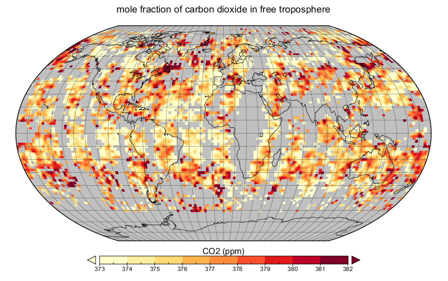
AIRS/Aqua L3 daily CO2 in the free troposphere (AIRS-only) 2.5 degrees x 2 degrees V005 (AIRS3C2D) at GES DISC
National Aeronautics and Space Administration —
The Atmospheric Infrared Sounder (AIRS) is a grating spectrometer (R = 1200) aboard the second Earth Observing System (EOS) polar-orbiting platform, EOS Aqua. In... -
Federal
EMIT L3 Aggregated Mineral Spectral Abundance and Uncertainty 0.5 Deg V001
National Aeronautics and Space Administration —
The Earth Surface Mineral Dust Source Investigation (EMIT) instrument measures surface mineralogy, targeting the Earth’s arid dust source regions. EMIT is installed... -
Federal
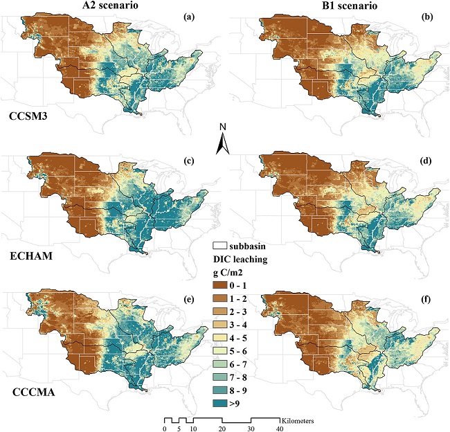
Export and Leaching of Carbon and Nitrogen from Mississippi River Basin, 1901-2099
National Aeronautics and Space Administration —
This dataset provides estimates for export and leaching of dissolved inorganic carbon (DIC), dissolved organic carbon (DIC), total organic carbon (TOC), particulate... -
Federal
Global Navigation Satellite System (GNSS) IGS Decoded Orbit Solution (30-second) from IGS Real-Time Product Streams from NASA CDDIS
National Aeronautics and Space Administration —
This derived product set consists of Global Navigation Satellite System satellite orbit products (daily files, generated daily) from the real-time IGS analysis center... -
Federal
CALIPSO Lidar Level 2 Vertical Feature Mask (VFM), V4-21
National Aeronautics and Space Administration —
CAL_LID_L2_VFM-Standard-V4-21 is the Cloud-Aerosol Lidar and Infrared Pathfinder Satellite Observations (CALIPSO) Lidar Level 2 Vertical Feature Mask (VFM), Version... -
Federal
GHRSST Level 4 AVHRR_OI Global Blended Sea Surface Temperature Analysis (GDS2) from NCEI
National Aeronautics and Space Administration —
A Group for High Resolution Sea Surface Temperature (GHRSST) global Level 4 sea surface temperature dataset is produced daily on a 0.25 degree grid at the NOAA... -
Federal
MODIS/Terra Gross Primary Productivity 8-Day L4 Global 500m SIN Grid V061
National Aeronautics and Space Administration —
The MOD17A2H Version 6.1 Gross Primary Productivity (GPP) product is a cumulative 8-day composite of values with 500 meter (m) pixel size based on the radiation use... -
Federal
SMEX05 Soil Moisture Network Data: Iowa, Version 1
National Aeronautics and Space Administration —
Notice to Data Users: The documentation for this data set was provided solely by the Principal Investigator(s) and was not further developed, thoroughly reviewed, or... -
Federal
Global Distribution of Root Profiles in Terrestrial Ecosystems
National Aeronautics and Space Administration —
Rooting depths were estimated from a global database of root profiles that was assembled from the primary literature to study relationships of abiotic and biotic... -
Federal
Global Mean Sea Level Trend from Integrated Multi-Mission Ocean Altimeters TOPEX/Poseidon, Jason-1, OSTM/Jason-2, Jason-3, and Sentinel-6 Version 5.2
National Aeronautics and Space Administration —
This dataset contains the Global Mean Sea Level (GMSL) trend generated from the Integrated Multi-Mission Ocean Altimeter Data for Climate Research Version 5.2. The... -
Federal
ASTER Level 1 Precision Terrain Corrected Registered At-Sensor Radiance V031
National Aeronautics and Space Administration —
The Terra Advanced Spaceborne Thermal Emission and Reflection Radiometer (ASTER) Level 1 Precision Terrain Corrected Registered At-Sensor Radiance (AST_L1T) Version... -
Federal
ATom: L2 In Situ Measurements from Single Particle Soot Photometer (SP2)
National Aeronautics and Space Administration —
This dataset provides the refractory black carbon mass concentration at one-second resolution measured by the Single Particle Soot Photometer (NOAA SP2) instrument... -
Federal
BOREAS TF-03 NSA-OBS Tower Flux, Meteorological, and Soil Temperature Data
National Aeronautics and Space Administration —
The BOREAS TF-03 team collected tower flux, surface meterological, and soil temperature data at the BOREAS NSA-OBS site continuously from the March 1994 through... -
Federal
Autonomous Parsivel Unit (APU) IMPACTS
National Aeronautics and Space Administration —
The Autonomous Parsivel Unit (APU) IMPACTS data were collected in support of the Investigation of Microphysics and Precipitation for Atlantic Coast-Threatening... -
Federal
LBA-ECO LC-01 SRTM 90-Meter Digital Elevation Model, Northern Ecuadorian Amazon
National Aeronautics and Space Administration —
This data set provides 90-meter resolution Digital Elevation Model data used in the University of North Carolina's Carolina Population Center (CPC) Ecuador Projects.... -
Federal
Ancillary total PM data from the MAIA Surface Monitor Network
National Aeronautics and Space Administration —
The MAIA Surface Monitor Stage 0 files are an ancillary dataset containing processed particulate matter (PM) measurements collected from a global in-situ surface... -
Federal
MODIS/Terra Land Surface Temperature/Emissivity 5-Min L2 Swath 1km V061
National Aeronautics and Space Administration —
The MOD11_L2 Version 6.1 swath product provides per-pixel Land Surface Temperature and Emissivity (LST&E) with a pixel size of 1,000 meters (m). The product is...

Official websites use .gov
A
.gov website belongs to an official government
organization in the United States.
Secure .gov websites use HTTPS
A
lock (
) or https:// means you’ve safely connected to
the .gov website. Share sensitive information only on official,
secure websites.