
-
Federal
Snow Properties and Wildlife Tracks in Washington and Alaska
National Aeronautics and Space Administration —
This dataset contains three field seasons of snow-wildlife observations conducted at 707 sites from January 2021 to March 2023 in Washington and Alaska, spanning a... -
Federal
SiB3 Modeled Global 1-degree Hourly Biosphere-Atmosphere Carbon Flux, 1998-2006
National Aeronautics and Space Administration —
The Simple Biosphere Model, Version 3 (SiB3) was used to produce a global data set of hourly carbon fluxes between the atmosphere and the terrestrial biosphere for... -
Federal
SiB4 Modeled Global 0.5-Degree Daily Carbon Fluxes and Pools, 2000-2018
National Aeronautics and Space Administration —
This dataset provides global daily output predicted by the Simple Biosphere Model, Version 4.2 (SiB4), at a 0.5-degree spatial resolution covering the time period... -
Federal
Snowmelt Timing Maps Derived from MODIS for North America, Version 2, 2001-2018
National Aeronautics and Space Administration —
This data set provides snowmelt timing maps (STMs), cloud interference maps, and a map with the count of calculated snowmelt timing values for North America. The STMs... -
Federal
Smoke/Sulfates, Clouds and Radiation Experiment in Brazil (SCAR-B) Data Set Version 5.5
National Aeronautics and Space Administration —
SCAR_B_G8_FIRE data are Smoke/Sulfates, Clouds and Radiation Experiment in Brazil, GOES-8 ABBA Diurnal Fire Product (1995 Fire Season) data.Smoke/Sulfates, Clouds and... -
Federal
SNF Forest Cover by Species/Strata
National Aeronautics and Space Administration —
The purpose of the SNF study was to improve our understanding of the relationship between remotely sensed observations and important biophysical parameters in the... -
Federal
LBA-ECO LC-07 Wetland Extent, Vegetation, and Inundation: Lowland Amazon Basin
National Aeronautics and Space Administration —
This data set provides a map of wetland extent, vegetation type, and dual-season flooding state of the entire lowland Amazon basin. As described in Hess et al.... -
Federal
KORUS-AQ DC-8 Aircraft In Situ J Value (Photolysis Rate) Data
National Aeronautics and Space Administration —
KORUSAQ_jValue_AircraftInSitu_DC8_Data are in-situ j-value (photolysis rate) measurements collected onboard the DC-8 aircraft during the KORUS-AQ field campaign.... -
Federal
Global N Cycle: Fluxes and N2O Mixing Ratios Originating from Human Activity
National Aeronautics and Space Administration —
Nitrogen is a major nutrient in terrestrial ecosystems and an important catalyst in tropospheric photochemistry. Over the last century human activities have... -
Federal
HAQES 3-Hourly Ensemble mean surface total PM2.5 concentration at census level, North America V1 (HAQES_NA_PM25_TOT_CENSUS) at GES DISC
National Aeronautics and Space Administration —
This product provides HAQES 3-hourly ensemble mean surface total PM2.5 concentration at the census level over the continental United States (CONUS). The Hazardous Air... -
Federal
GPM SAPHIR on MT1 (PRPS) Radiometer Precipitation Profiling L2 1.5 hours 10 km V06 (GPM_2APRPSMT1SAPHIR) at GES DISC
National Aeronautics and Space Administration —
Version 6 is the current version of this dataset. Older versions are no longer available and have been superseded by Version 6. The Precipitation Retrieval and... -
Federal
GPM Ground Validation Doppler on Wheels (DOW) OLYMPEX
National Aeronautics and Space Administration —
The GPM Ground Validation Doppler on Wheels (DOW) OLYMPEX V2 dataset was obtained by a dual-polarization and dual-frequency X-band mobile radar operated by the Center... -
Federal
GPM Ground Validation Micro Rain Radar 2 (MRR-2) UConn
National Aeronautics and Space Administration —
gpmmrr2uconn -
Federal
HAQES 3-Hourly Ensemble mean surface PM2.5 Black Carbon concentration, North America V1 (HAQES_NA_PM25_BC) at GES DISC
National Aeronautics and Space Administration —
This product provides HAQES 3-hourly ensemble mean surface PM2.5 Black Carbon concentration over the continental United States (CONUS) and surrounding regions. The... -
Federal
TOVS GLA MONTHLY GRIDS from NOAA-12 V01 (TOVSAMND) at GES DISC
National Aeronautics and Space Administration —
This dataset (TOVSAMND) contains the TIROS Operational Vertical Sounder (TOVS) level 3 geophysical parameters derived using data from NOAA-12 and the physical... -
Federal
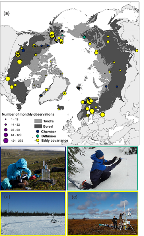
The ABCflux Database: Arctic-Boreal CO2 Flux and Site Environmental Data, 1989-2020
National Aeronautics and Space Administration —
This Arctic-Boreal CO2 fluxes (ABCflux) dataset contains monthly aggregates of terrestrial net ecosystem CO2 exchange and its derived partitioned component fluxes:... -
Federal
TCSP AMPR BRIGHTNESS TEMPERATURE (TB) V2
National Aeronautics and Space Administration —
The TCSP AMPR Brightness Temperature (TB) dataset consists of brightness temperature measurements from July 5, 2005 to July 27, 2005. The Advanced Microwave... -
Federal
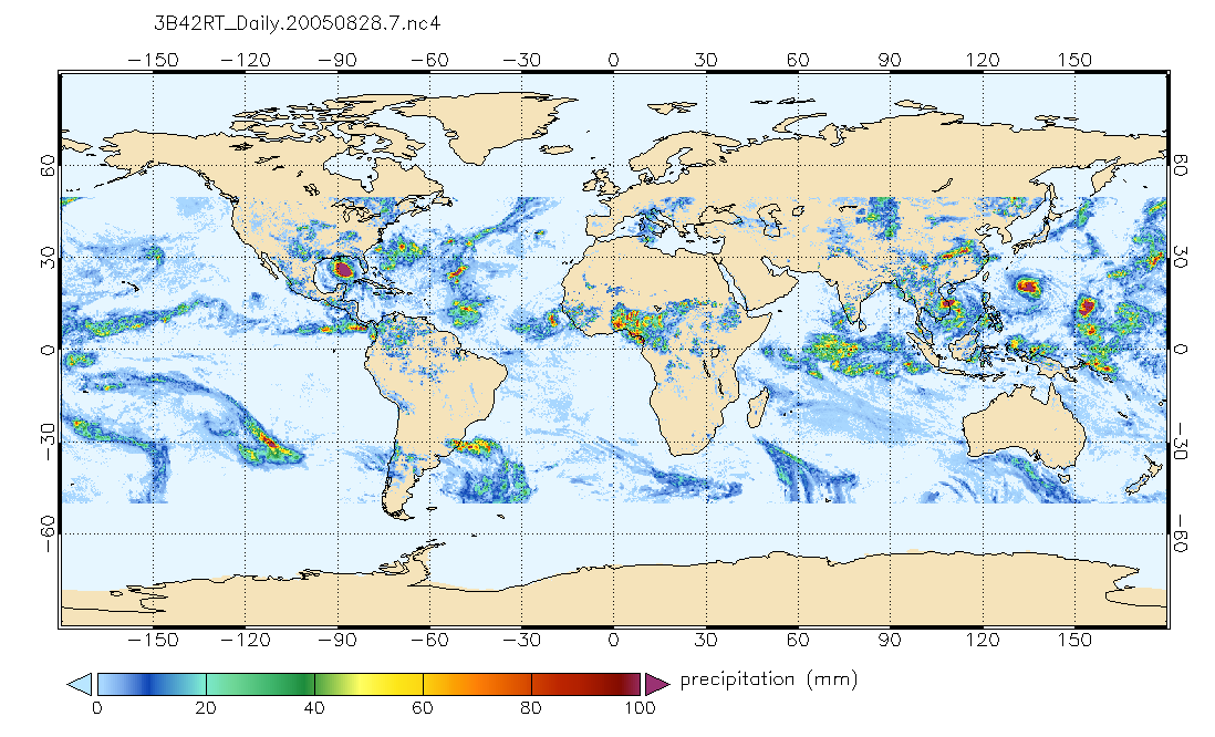
TRMM (TMPA-RT) Near Real-Time Precipitation L3 1 day 0.25 degree x 0.25 degree V7 (TRMM_3B42RT_Daily) at GES DISC
National Aeronautics and Space Administration —
TMPA (3B42RT_Daily) dataset have been discontinued as of Dec. 31, 2019, and users are strongly encouraged to shift to the successor IMERG dataset (doi:... -
Federal
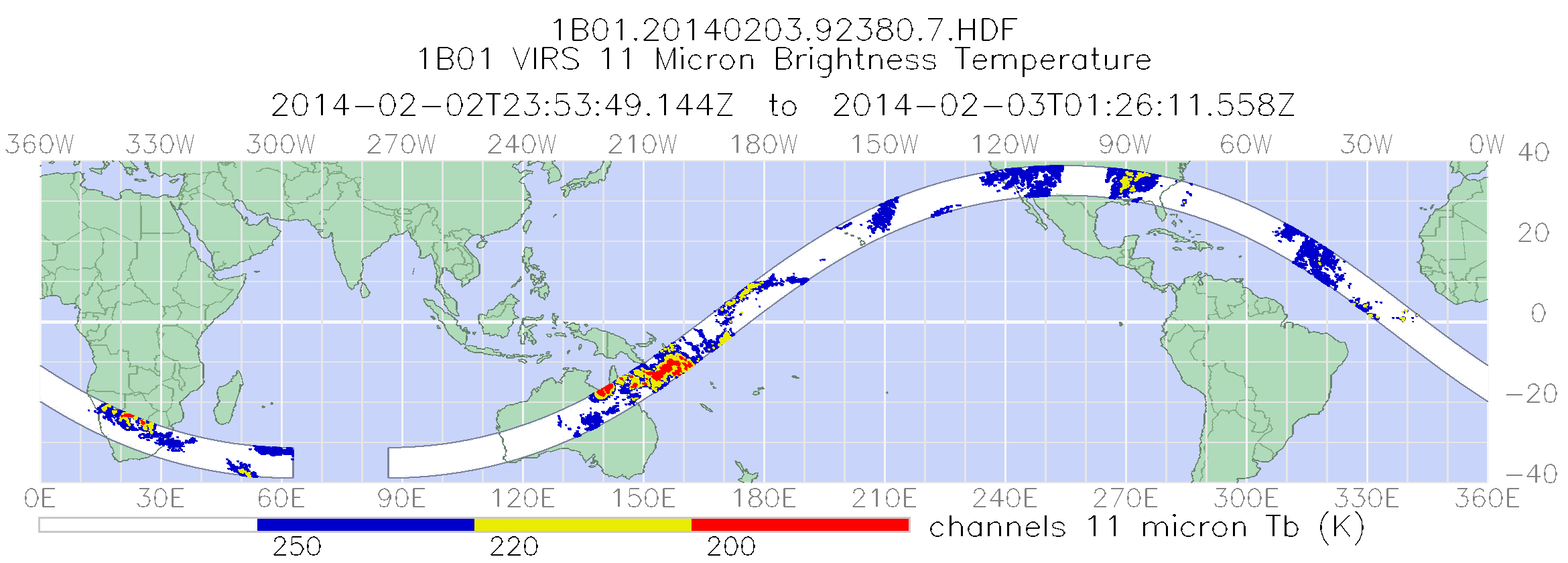
TRMM Visible and Infrared Scanner Calibrated Radiances L1B 1.5 hours V7 (TRMM_1B01) at GES DISC
National Aeronautics and Space Administration —
This TRMM Visible and Infrared Scanner (VIRS) Level 1B Calibrated Radiance Product (1B01) contains calibrated radiances and auxiliary geolocation information from the...

Official websites use .gov
A
.gov website belongs to an official government
organization in the United States.
Secure .gov websites use HTTPS
A
lock (
) or https:// means you’ve safely connected to
the .gov website. Share sensitive information only on official,
secure websites.