
-
Federal
H12993: NOS Hydrographic Survey , 2018-10-05
National Oceanic and Atmospheric Administration, Department of Commerce —
The National Oceanic and Atmospheric Administration (NOAA) has the statutory mandate to collect hydrographic data in support of nautical chart compilation for safe... -
Federal
H10842: NOS Hydrographic Survey , Charleston Harbor, South Carolina and Adjoining Waterways, South Carolina, 1998-11-16
National Oceanic and Atmospheric Administration, Department of Commerce —
The National Oceanic and Atmospheric Administration (NOAA) has the statutory mandate to collect hydrographic data in support of nautical chart compilation for safe... -
Federal
H11835: NOS Hydrographic Survey , Gulf of Mexico, Louisiana, 2008-08-20
National Oceanic and Atmospheric Administration, Department of Commerce —
The National Oceanic and Atmospheric Administration (NOAA) has the statutory mandate to collect hydrographic data in support of nautical chart compilation for safe... -
Federal
H13965: NOS Hydrographic Survey , 2024-12-02
National Oceanic and Atmospheric Administration, Department of Commerce —
The National Oceanic and Atmospheric Administration (NOAA) has the statutory mandate to collect hydrographic data in support of nautical chart compilation for safe... -
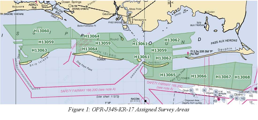
Federal
H13067: NOS Hydrographic Survey , Mississippi Sound and Vicinity, 2017-10-26
National Oceanic and Atmospheric Administration, Department of Commerce —
The National Oceanic and Atmospheric Administration (NOAA) has the statutory mandate to collect hydrographic data in support of nautical chart compilation for safe... -
Federal
Multibeam collection for SKQ202112T: Multibeam data collected aboard Sikuliaq from 10-Aug-21 to 15-Aug-21, Seward, Alaska to Nome, Alaska
National Oceanic and Atmospheric Administration, Department of Commerce —
This data set is part of a larger set of data called the Multibeam Bathymetry Database (MBBDB) where other similar data can be found -
Federal
H13143: NOS Hydrographic Survey , 2018-11-05
National Oceanic and Atmospheric Administration, Department of Commerce —
The National Oceanic and Atmospheric Administration (NOAA) has the statutory mandate to collect hydrographic data in support of nautical chart compilation for safe... -
Federal
F00415: NOS Hydrographic Survey , Southern Chesapeake Bay Item Investigations, Virginia, 1995-05-15
National Oceanic and Atmospheric Administration, Department of Commerce —
The National Oceanic and Atmospheric Administration (NOAA) has the statutory mandate to collect hydrographic data in support of nautical chart compilation for safe... -
Federal
H10583: NOS Hydrographic Survey , Port Angeles, Washington, 1995-01-26
National Oceanic and Atmospheric Administration, Department of Commerce —
The National Oceanic and Atmospheric Administration (NOAA) has the statutory mandate to collect hydrographic data in support of nautical chart compilation for safe... -
Federal
H12078: NOS Hydrographic Survey , Pavlof Islands, Alaska, 2009-08-05
National Oceanic and Atmospheric Administration, Department of Commerce —
The National Oceanic and Atmospheric Administration (NOAA) has the statutory mandate to collect hydrographic data in support of nautical chart compilation for safe... -
Federal
4-m Grid of the Combined Multibeam and LIDAR Bathymetry Generated from National Oceanic and Atmospheric Administration (NOAA) Surveys H11224, H11225, H11250, H11251, H11252, H11361, H11441, H11442, H11445, H11446, H11997, H11999, H12012, and H12013 Offshore in Eastern Long Island Sound and Westernmost Block Island Sound (ELISCOMB_UTM, UTM Zone 18, NAD83)
Department of the Interior —
The USGS, in cooperation with NOAA and the Connecticut DEP, is producing detailed maps of the seafloor in Long Island Sound. The current phase of this cooperative... -
Federal
Multibeam collection for B00220: Multibeam data collected aboard Mt. Mitchell from 25-Apr-90 to 28-Apr-90, Norfolk, Virginia to Norfolk, Virginia
National Oceanic and Atmospheric Administration, Department of Commerce —
This data set is part of a larger set of data called the Multibeam Bathymetry Database (MBBDB) where other similar data can be found -
Federal
H10570: NOS Hydrographic Survey , Northwest Prince Willliam Sound, Alaska, 1994-09-29
National Oceanic and Atmospheric Administration, Department of Commerce —
The National Oceanic and Atmospheric Administration (NOAA) has the statutory mandate to collect hydrographic data in support of nautical chart compilation for safe... -
Federal
Bathymetry 2M Grid, US Virgin Islands, 2005, UTM 20 NAD83
National Oceanic and Atmospheric Administration, Department of Commerce —
This dataset contains a unified ESRI Grid with 2 meter cell size representing the bathymetry of selected portions of seafloor around St. Croix, St. Thomas, and St.... -
Federal
H11479: NOS Hydrographic Survey , Southwest Alaska Peninsula,. Alaska, 2005-08-21
National Oceanic and Atmospheric Administration, Department of Commerce —
The National Oceanic and Atmospheric Administration (NOAA) has the statutory mandate to collect hydrographic data in support of nautical chart compilation for safe... -
Federal
H10320: NOS Hydrographic Survey , Corpus Christi and Aransas Bays, Texas, 1990-02-12
National Oceanic and Atmospheric Administration, Department of Commerce —
The National Oceanic and Atmospheric Administration (NOAA) has the statutory mandate to collect hydrographic data in support of nautical chart compilation for safe... -
Federal
NOAA TIFF Image - NF13_PR_Haystack_95khz_bathy_4m.tif, Puerto Rico 2013, Northeast Reserve, Haystack Seamount, Seafloor Characterization of the US Caribbean - Nancy Foster - NF-13-2 USVI (2013), UTM 20N NAD83
National Oceanic and Atmospheric Administration, Department of Commerce —
This image represents a 4 meter resolution interpolated bathymetric grid of a seamount East of Fajardo, Puerto Rico. NOAA's NOS/NCCOS/CCMA Biogeography Team, in... -
Federal
H10430: NOS Hydrographic Survey , Cook Inlet, Alaska, 1992-08-04
National Oceanic and Atmospheric Administration, Department of Commerce —
The National Oceanic and Atmospheric Administration (NOAA) has the statutory mandate to collect hydrographic data in support of nautical chart compilation for safe... -
Federal
Multibeam collection for CV07_SFI_GWB: Multibeam data collected aboard Celtic Voyager from 09-Feb-07 to 13-Feb-07, None to None
National Oceanic and Atmospheric Administration, Department of Commerce —
This data set is part of a larger set of data called the Multibeam Bathymetry Database (MBBDB) where other similar data can be found -
Federal
F00837: NOS Hydrographic Survey , 2021-09-05
National Oceanic and Atmospheric Administration, Department of Commerce —
The National Oceanic and Atmospheric Administration (NOAA) has the statutory mandate to collect hydrographic data in support of nautical chart compilation for safe...

Official websites use .gov
A
.gov website belongs to an official government
organization in the United States.
Secure .gov websites use HTTPS
A
lock (
) or https:// means you’ve safely connected to
the .gov website. Share sensitive information only on official,
secure websites.
.jpg)
.jpg)
.jpg)
.jpg)
.jpg)
.jpg)
.jpg)