
-
Federal
Nadir Photographs Taken During Low-Altitude Transects of the Arctic Network of National Park Units and Selawik National Wildlife Refuge, Alaska, July 2013
Department of the Interior —
This dataset contains aerial nadir digital photos and ecotype classification data determined from the photos. Aerial nadir photos were taken at 5 second intervals of... -
Federal
Infrared thermography data from the Ivanpah Solar Electric Generating System (ISEGS) Facility Recorded by the USGS during Spring and Fall 2014
Department of the Interior —
In this observational pilot study, we worked at the largest existing solar tower facility in the world (Ivanpah Solar Electric Generating System - ISEGS) to assess... -
Federal
Data Recordings from the Ivanpah Solar Electric Generating System (ISEGS) Facility Recorded by the USGS during Spring and Fall 2014
Department of the Interior —
These data consist of several discrete data resources captured at the Ivanpah Solar Electric Generating System (ISEGS) during 2014. The data include 1) Thermal... -
Federal
Unoccupied Aerial System-mounted image velocimetry and Doppler velocity radar data for computation of river velocity and discharge collected at seven locations in Colorado in 2023: Ground Control
Department of the Interior —
This child item contains information about associating the calibration images and video to real-world distances using ground control points for each field site. The... -
Federal
Unoccupied Aerial System-mounted image velocimetry and Doppler velocity radar data for computation of river velocity and discharge collected at seven locations in Colorado in 2023: Radar Spectra
Department of the Interior —
This child item contains Doppler radar velocimetry spectra measurements for each field site where the radars were deployed. Each field site is abbreviated in various... -
Federal
Sea-floor videos and location of bottom video tracklines collected in Long Island Sound, Connecticut and New York, in fall 2017 and spring 2018 by the U.S. Geological Survey, University of Connecticut, and University of New Haven during field activities 2017-056-FA and 2018-018-FA (MP4 video files and polyline shapefile)
Department of the Interior —
Two marine geological surveys were conducted in Long Island Sound, Connecticut and New York, in fall 2017 and spring 2018 by the U.S. Geological Survey (USGS),... -
Federal
Video Transect Images from the Hawaii Coral Reef Assessment and Monitoring Program (CRAMP):Data from 2003 (NODC Accession 0001732)
National Oceanic and Atmospheric Administration, Department of Commerce —
This dataset consists of video transect images (TIF files) from CRAMP surveys taken in 2003 at 15 sites, some of which had multiple depths. Estimates of substrate... -
Federal
Benthic Habitats of Buck Island Reef National Monument, St. Croix U.S. Virgin Islands, 2004-02-18 to 2011-08-30 (NCEI Accession 0285904)
National Oceanic and Atmospheric Administration, Department of Commerce —
This data package contains information about the geology and biology of the seafloor from approximately 0 to 1,830 meters in Buck Island Reef National Monument... -
Federal
Still-image frame grabs and benthic habitat interpretation of underwater video footage, March 2014, Faga`alu Bay, American Samoa
Department of the Interior —
Underwater video was collected in March 2014 in the nearshore waters of Faga`alu Bay on the island of Tutuila, American Samoa, as part of the U.S. Geological Survey... -
Federal
CRED Fish Biomass Estimates map at French Frigate Shoals, 2001-2008
National Oceanic and Atmospheric Administration, Department of Commerce —
This map displays fish biomass observation locations overlaid on bathymetry -
Federal
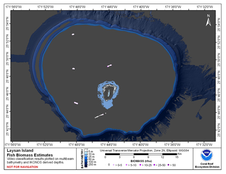
CRED Fish Biomass Estimates map at Laysan Island
National Oceanic and Atmospheric Administration, Department of Commerce —
This map displays fish biomass observation locations overlaid on bathymetry -
Federal
Video transects of the sea floor on Stellwagen Bank during U.S. Geological Survey field activity 2016-038-FA, aboard the R/V Auk, Sept. 16 and 19, 2016
Department of the Interior —
This field activity is part of the effort to map geologic substrates of the Stellwagen Bank National Marine Sanctuary region off Boston, Massachusetts. The overall... -
Federal
Videos taken in support of Image Velocimetry at the Arkansas River at Parkdale, CO March 20–21, 2018
Department of the Interior —
Videos and imagery collected of the Arkansas River at Parkdale, CO on March 20–21, 2018 as part of the US Geological Survey (USGS) "2018 Airshow". These videos... -
Federal
Long-Term Monitoring at the East and West Flower Garden Banks National Marine Sanctuary 2002-2006, (NODC Accession 0012632)
National Oceanic and Atmospheric Administration, Department of Commerce —
The Long-Term Monitoring at the East and West Flower Garden Banks National Marine Sanctuary 2002-2006 data include biological and oceanographic measurements collected... -
Federal
Video Surveillance Imagery of the Ivanpah Solar Electric Generating System (ISEGS) Facility Recorded by the USGS during Spring and Fall 2014
Department of the Interior —
In this observational pilot study, we worked at the largest existing solar tower facility in the world (Ivanpah Solar Electric Generating System - ISEGS) to assess... -
Federal
CRED Optical Validation Data at the island of Ofu and Olosega in American Samoa, 2012 to support Benthic Habitat Mapping (TOAD)
National Oceanic and Atmospheric Administration, Department of Commerce —
Optical validation data were collected using the Tethered Optical Assessment Device (TOAD), a sled equipped with underwater video camera, still camera and lights.... -
Federal
Video transects of the sea floor on Stellwagen Bank during U.S. Geological Survey field activity 2019-008-FA, aboard the R/V Auk, July 30, 31, and August 1, 2019
Department of the Interior —
This field activity is part of the effort to map geologic substrates of the Stellwagen Bank National Marine Sanctuary region off Boston, Massachusetts. The overall... -
Federal
NCCOS Assessment: Benthic habitat maps of Saipan Lagoon, Commonwealth of the Northern Mariana Islands (NCEI Accession 0162517)
National Oceanic and Atmospheric Administration, Department of Commerce —
Highly detailed maps of benthic habitats within the lagoon along the western shore of Saipan were created by NOAA NCCOS. This data collection includes the information... -
Federal
Location of bottom video tracklines collected during field activity 2011-015-FA by the U.S. Geological Survey and Massachusetts Office of Coastal Zone Management offshore of Massachusetts around Cape Cod and the Islands in September 2011 (polyline shapefile)
Department of the Interior —
Accurate data and maps of sea-floor geology are important first steps toward protecting habitat, delineating marine resources, and assessing environmental changes due... -
Federal
Nadir Videos Taken During Low-Altitude Transects of the Arctic Network of National Park Units and Selawik National Wildlife Refuge, Alaska, July 2013
Department of the Interior —
This dataset contains aerial nadir video segments from a GoPro Hero3 Black Edition (focal length 2.77 mm; 60 frames per second) of the arctic landscape during low...

Official websites use .gov
A
.gov website belongs to an official government
organization in the United States.
Secure .gov websites use HTTPS
A
lock (
) or https:// means you’ve safely connected to
the .gov website. Share sensitive information only on official,
secure websites.