
-
Federal
C-HARM v1 2-Day Forecast, Pseudo-nitzschia, cellular domoic acid, and particular domoic acid probability, California and Southern Oregon coast, 2018-2022, Lon+/-180
National Oceanic and Atmospheric Administration, Department of Commerce —
The C-HARM model generates nowcast and forecasts of the probability of Pseudo-nitzschia concentrations of in excess of 10,000 cells/L in California and Southern... -
Federal
points, transects, beach width: Barrier island geomorphology and shorebird habitat metrics at 50-m alongshore transects and 5-m cross-shore points: Rhode Island National Wildlife Refuge, RI, 2014
Department of the Interior —
Understanding how sea-level rise will affect coastal landforms and the species and habitats they support is critical for crafting approaches that balance the needs of... -
Federal
points, transects, beach width: Barrier island geomorphology and shorebird habitat metrics at 50-m alongshore transects and 5-m cross-shore points: Edwin B. Forsythe NWR, NJ, 2010
Department of the Interior —
Understanding how sea-level rise will affect coastal landforms and the species and habitats they support is critical for crafting approaches that balance the needs of... -
Federal
C-HARM v1 1-Day Forecast, Pseudo-nitzschia, cellular domoic acid, and particular domoic acid probability, California and Southern Oregon coast, 2018-2022
National Oceanic and Atmospheric Administration, Department of Commerce —
The C-HARM model generates nowcast and forecasts of the probability of Pseudo-nitzschia concentrations of in excess of 10,000 cells/L in California and Southern... -
Federal
Next Generation RivGen Power System: Feasibility Assessment of Hydroacoutics Data for Development of a Probability of Encounter Model of Salmon Smolts
Department of Energy —
This document contains a feasibility assessment for salmon smolt characterization and analysis based on existing hydroacoustics data and probability of encounter model. -
Federal
SE Great Basin Play Fairway Analysis PFA Models and Probability Map
Department of Energy —
This submission includes a Na/K geothermometer probability greater than 200 deg C map, as well as two play fairway analysis (PFA) models. The probability map acts as... -
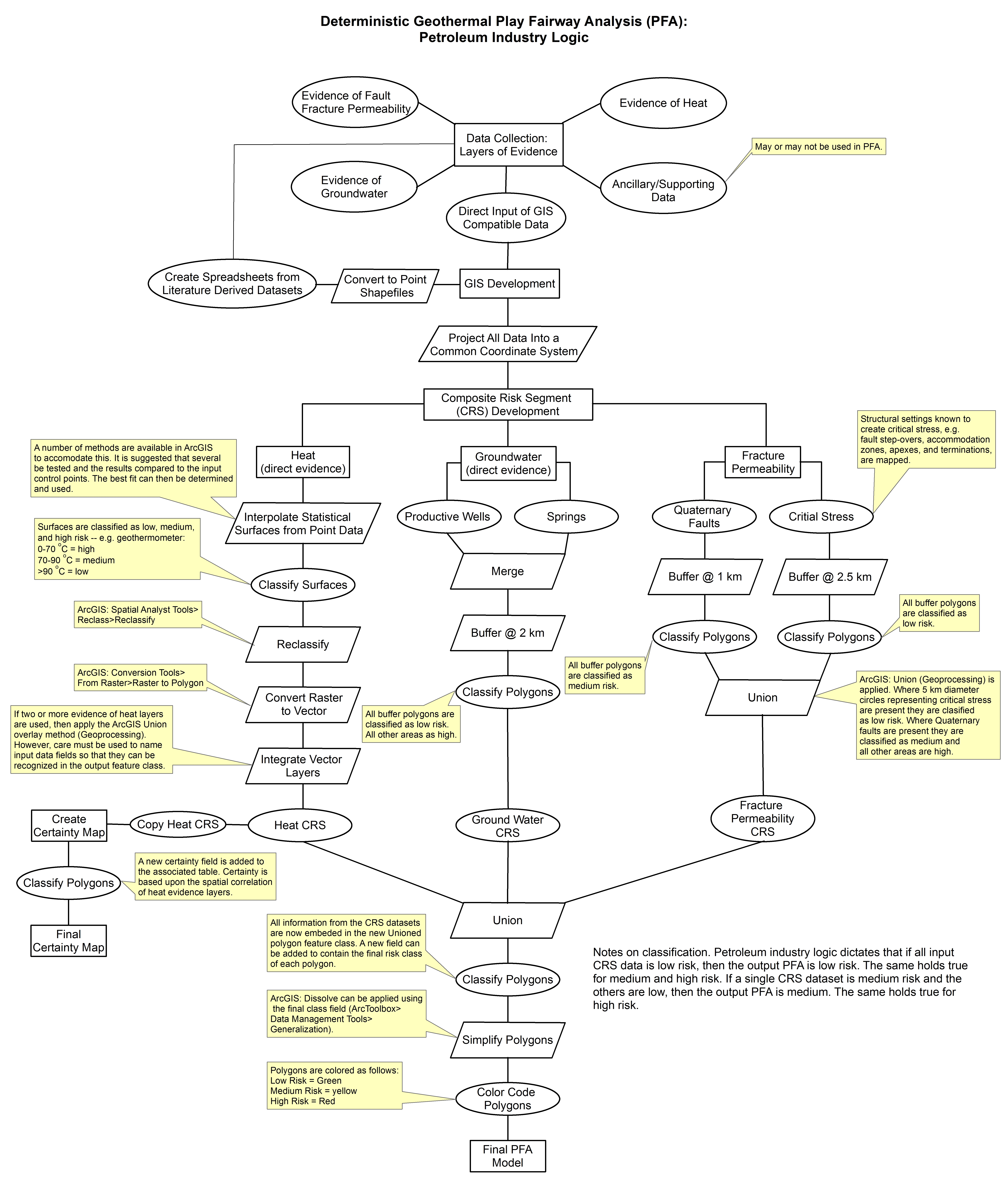
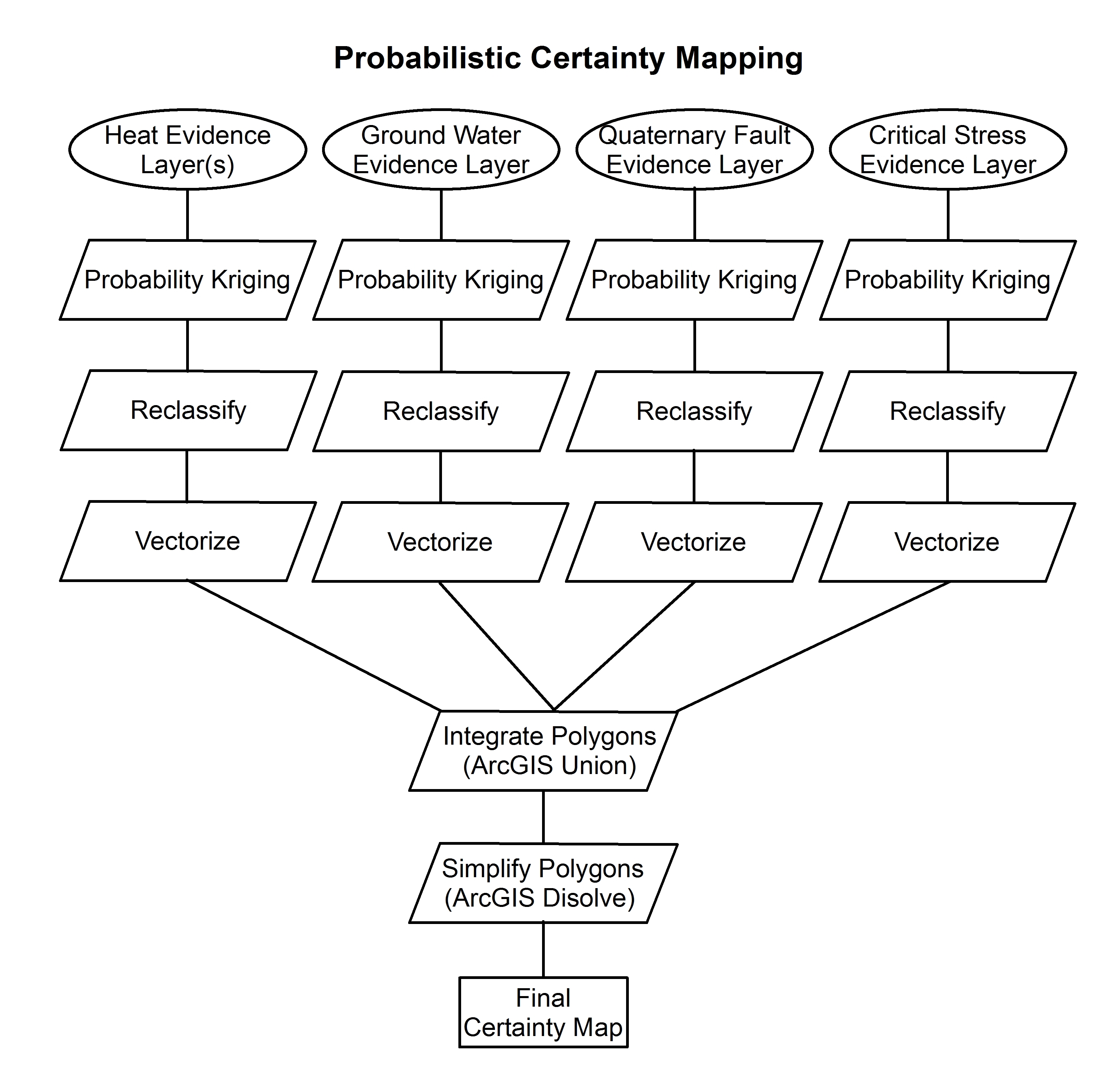
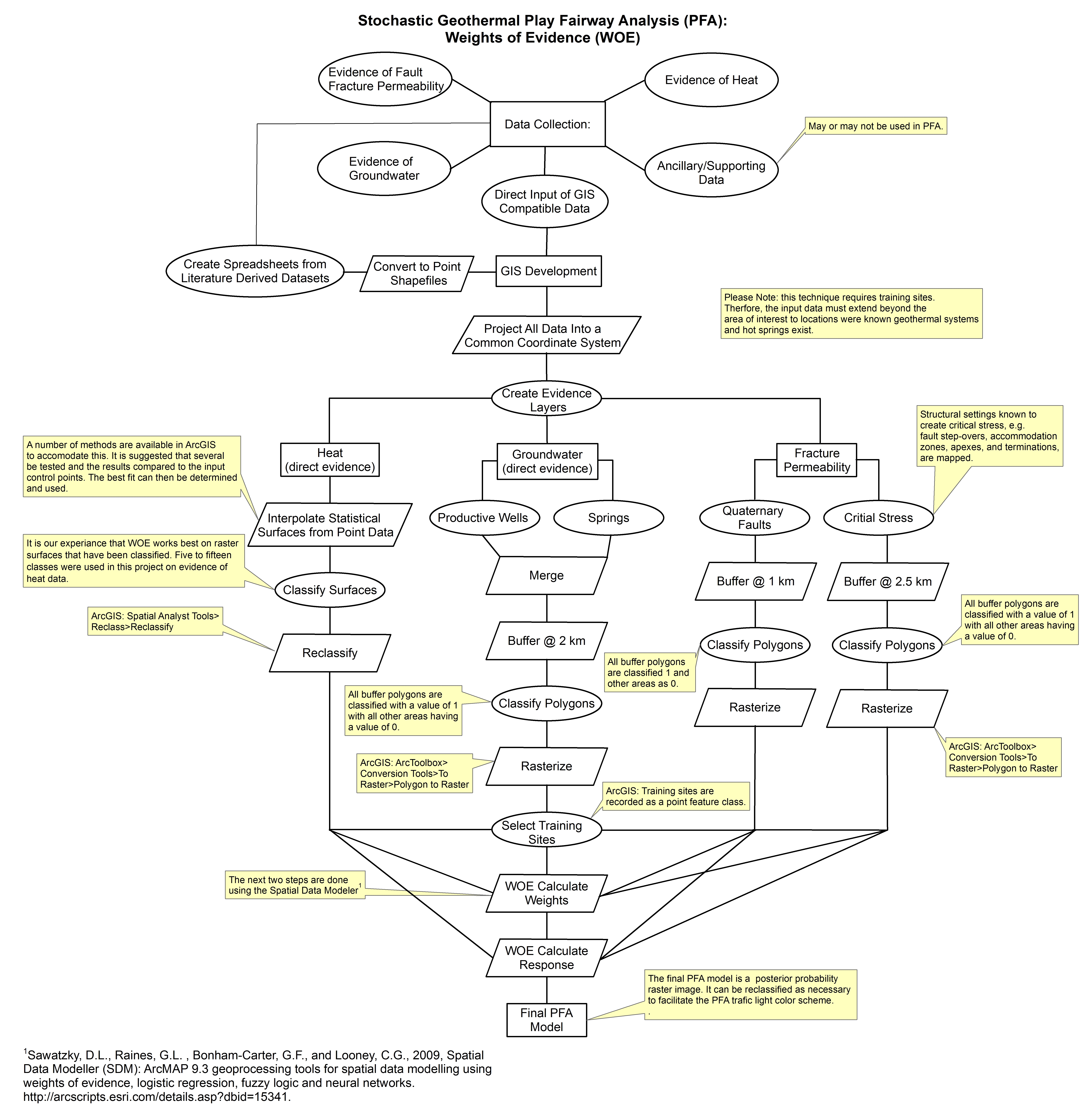
Federal
Tularosa Basin Play Fairway Analysis: Methodology Flow Charts
Department of Energy —
These images show the comprehensive methodology used for creation of a Play Fairway Analysis to explore the geothermal resource potential of the Tularosa Basin, New... -
Federal
Front Probability, GOES Imager, Western Hemisphere, 2007-2020, EXPERIMENTAL (5 Day Composite), Lon+/-180
National Oceanic and Atmospheric Administration, Department of Commerce —
The data indicates the probability of oceanic sea surface temperature fronts off the California coast. They were created using remote sensing sea surface temperature... -
Federal
Front Probability, GOES Imager, Western Hemisphere, 2000-2020, EXPERIMENTAL (1 Day Composite)
National Oceanic and Atmospheric Administration, Department of Commerce —
The data indicates the probability of oceanic sea surface temperature fronts off the California coast. They were created using remote sensing sea surface temperature... -
Federal
Raster dataset showing the probability of detecting atrazine/desethyl-atrazine in ground water in Colorado, hydrogeomorphic regions included and atrazine use estimates not included.
Department of the Interior —
This dataset is one of eight datasets produced by this study. Four of the datasets predict the probability of detecting atrazine and(or) desethyl-atrazine (a... -
Federal
points, transects, beach width: Barrier island geomorphology and shorebird habitat metrics at 50-m alongshore transects and 5-m cross-shore points: Rockaway Peninsula, NY, 2013–2014
Department of the Interior —
Understanding how sea-level rise will affect coastal landforms and the species and habitats they support is critical for crafting approaches that balance the needs of... -
Federal
Point shapefile of probability of shoreline change along the U.S. Atlantic Coast (ProbSLC_AtlanticData.shp)
Department of the Interior —
During the 21st century, sea-level rise will have a wide range of effects on coastal environments, human development and infrastructure in coastal areas. Consequently... -
Federal
points, transects, beach width: Barrier island geomorphology and shorebird habitat metrics at 50-m alongshore transects and 5-m cross-shore points: Rockaway Peninsula, NY, 2012
Department of the Interior —
Understanding how sea-level rise will affect coastal landforms and the species and habitats they support is critical for crafting approaches that balance the needs of... -
Federal
C-HARM v1, 3-Day Forecast, Pseudo-nitzschia, cellular domoic acid, and particular domoic acid probability, California and Southern Oregon coast, 2018-2022, Lon+/-180
National Oceanic and Atmospheric Administration, Department of Commerce —
The C-HARM model generates nowcast and forecasts of the probability of Pseudo-nitzschia concentrations of in excess of 10,000 cells/L in California and Southern... -
Federal
Raster dataset showing the probability of detecting atrazine/desethyl-atrazine in ground water in Colorado, hydrogeomorphic regions not included and atrazine use estimates included.
Department of the Interior —
This dataset is one of eight datasets produced by this study. Four of the datasets predict the probability of detecting atrazine and(or) desethyl-atrazine (a... -
Federal
points, transects, beach width: Barrier island geomorphology and shorebird habitat metrics at 50-m alongshore transects and 5-m cross-shore points: Edwin B. Forsythe NWR, NJ, 2012
Department of the Interior —
Understanding how sea-level rise will affect coastal landforms and the species and habitats they support is critical for crafting approaches that balance the needs of... -
Federal
Front Probability, GOES Imager, Western Hemisphere, 2005-2020, EXPERIMENTAL (14 Day Composite)
National Oceanic and Atmospheric Administration, Department of Commerce —
The data indicates the probability of oceanic sea surface temperature fronts off the California coast. They were created using remote sensing sea surface temperature... -
Federal
On Tracer Breakthrough Curve Dataset Size, Shape, and Statistical Distribution
U.S. Environmental Protection Agency —
A tracer breakthrough curve (BTC) for each sampling station is the ultimate goal of every quantitative hydrologic tracing study, and dataset size can critically... -
Federal
points, transects, beach width: Barrier island geomorphology and shorebird habitat metrics at 50-m alongshore transects and 5-m cross-shore points: Monomoy Island, MA, 2013-2014
Department of the Interior —
Understanding how sea-level rise will affect coastal landforms and the species and habitats they support is critical for crafting approaches that balance the needs of... -
Federal
Raster dataset showing the probability of elevated concentrations of nitrate in ground water in Colorado, hydrogeomorphic regions not included and fertilizer use estimates included.
Department of the Interior —
This dataset is one of eight datasets produced by this study. Four of the datasets predict the probability of detecting atrazine and(or) desethyl-atrazine (a...

Official websites use .gov
A
.gov website belongs to an official government
organization in the United States.
Secure .gov websites use HTTPS
A
lock (
) or https:// means you’ve safely connected to
the .gov website. Share sensitive information only on official,
secure websites.