

193 datasets found
-
City
LocallyDesignatedHistoricDistricts
City of Bloomington —
This map layer contains Historic Districts within City of Bloomington, Indiana that have been locally designated by ordinance. Historic Districts can be objects,... -
Federal
HHS COVID-19 Small Area Estimations Survey - Monovalent Booster Audience - Wave 13
U.S. Department of Health & Human Services —
The goal of the Monthly Outcome Survey (MOS) Small Area Estimations (SAE) are to generate estimates of the proportions of adults, by county and month, who were in the... -
Federal
HHS COVID-19 Small Area Estimations Survey - Primary Vaccine Series - Wave 18
U.S. Department of Health & Human Services —
The goal of the Monthly Outcome Survey (MOS) Small Area Estimations (SAE) is to generate estimates of the proportions of adults, by county and month, who were in the... -
Federal
Mesoscale Analy. and Prediction Sys.: 60 km grid covering Southern Great Plains
Department of Energy —
No description found -
City
Areas Intended for Annexation AIFA 1996
City of Bloomington —
This map data layer represents the former Areas Intended for Annexation for the City of Bloomington, Indiana, also known as the AIFA. This area was establish by an... -
City
Proposed Annexation 2021
City of Bloomington —
Proposed 2021 annexation areas for the City of Bloomington used to define and display areas under consideration for annexation. -
City
Monroe County Fire Districts
City of Bloomington —
The Fire Dispatch Zones define agency and station response areas for Fire Districts within Monroe County, Indiana. They were created for use within the Spillman... -
Federal
HHS COVID-19 Small Area Estimations Survey - Monovalent Booster Audience - Wave 14
U.S. Department of Health & Human Services —
The goal of the Monthly Outcome Survey (MOS) Small Area Estimations (SAE) are to generate estimates of the proportions of adults, by county and month, who were in the... -
Federal
HHS COVID-19 Small Area Estimations Survey - Monovalent Booster Audience - Wave 21
U.S. Department of Health & Human Services —
The goal of the Monthly Outcome Survey (MOS) Small Area Estimations (SAE) are to generate estimates of the proportions of adults, by county and month, who were in the... -
Federal
HHS COVID-19 Small Area Estimations Survey - Updated Bivalent Vaccine Audience - Wave 22
U.S. Department of Health & Human Services —
The goal of the Monthly Outcome Survey (MOS) Small Area Estimations (SAE) is to generate estimates of the proportions of adults, by county and month, who were in the... -
County
Virtual Map Counter
King County, Washington —
Here you will find a selection of maps that have been produced by various King County departments and divisions and are hosted on the KCGIS Center website. -
Federal
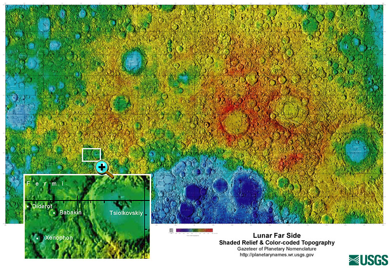
Gazetteer of Planetary Nomenclature: Moon: 1:10 million-scale Shaded Relief and Color-coded Topography: Far Side
National Aeronautics and Space Administration —
These lunar maps display the four different areas of the moon with color-coded topography in low and high resolution approved by the International Astronomical Union... -
City
Monroe County Incorporated Areas
City of Bloomington —
This map data layer represents boundaries for incorporated cities and towns within Monroe County Indiana. -
City
NYCDEP Recreation Area Maps
City of New York —
NYCDEP Recreation Area Maps Note: WMU = New York State Department of Environmental Conservation Wildlife Management Unit. Hunters should verify the WMU is correct.... -
Federal
HHS COVID-19 Small Area Estimations Survey - Primary Vaccine Series - Wave 01
U.S. Department of Health & Human Services —
The goal of the Monthly Outcome Survey (MOS) Small Area Estimations (SAE) is to generate estimates of the proportions of adults, by county and month, who were in the... -
City
Neighborhoods
City of Somerville —
ESRI polygon feature class representing City of Somerville, Massachusetts neighborhood boundaries. -
City
Parking Locations
City of Bloomington —
This layer represents the City's parking facilities in Bloomington, Indiana that are enforced by the Parking Services division of the City of Bloomington Public... -
Federal
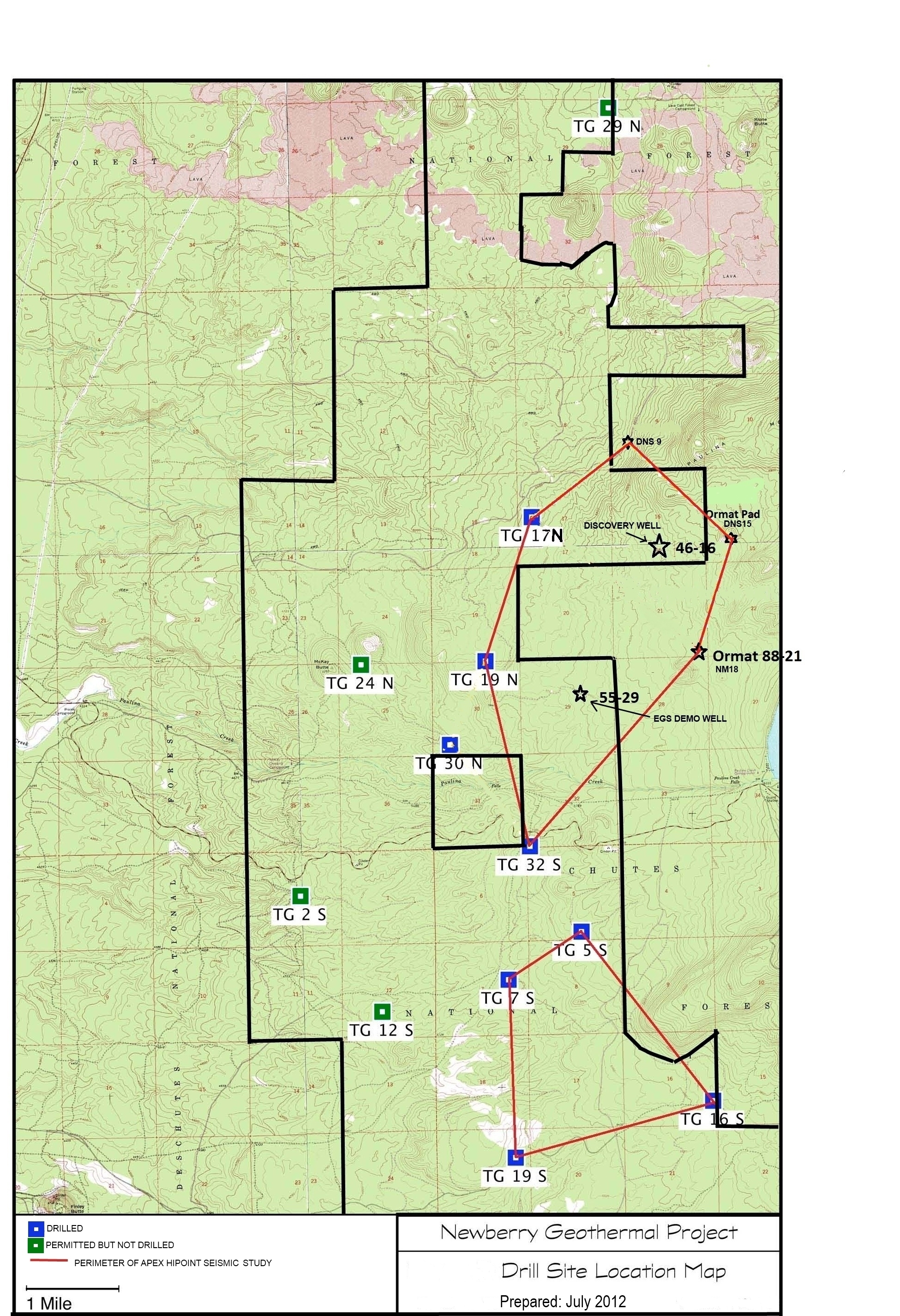
Map of Validation of Innovative Exploration Technologies for Newberry Volcano
Department of Energy —
A map showing location of wells permitted, drilled and seismic test, as part of validation of innovative exploration technologies done for the Newberry Volcano... -
City
Contours 1 Ft
City of Somerville —
ESRI line feature class representing City of Somerville, Massachusetts 1-foot contour intervals. -
Federal
GIBS Geospatial Data Abstraction Library (GDAL)
National Aeronautics and Space Administration —
GDAL is an open source translator library for raster geospatial data formats that presents a single abstract data model to the calling application for all supported...
193 datasets found