
-
Federal
NY/NJ Metro Area, Hudson River, and South Long Island 2016 HYDROP (Hydrography Polygons)
National Oceanic and Atmospheric Administration, Department of Commerce —
This data set contains vector polygons representing the coastal shoreline and hydrography used in the creation of the Environmental Sensitivity Index (ESI) for New... -
Federal
Sensitivity of Coastal Environments and Wildlife to Spilled Oil: Hudson River: HYDRO (Hydrography Lines and Polygons)
National Oceanic and Atmospheric Administration, Department of Commerce —
This data set contains vector lines and polygons representing coastal hydrography used in the creation of the Environmental Sensitivity Index (ESI) for the Hudson... -
Federal
National Status and Trends, Benthic Surveillance Project Chemistry Data, 1984-1992, National Centers for Coastal Ocean Science
National Oceanic and Atmospheric Administration, Department of Commerce —
The National Status and Trends (NS&T) Benthic Surveillance Project Chemistry data file reports the trace concentrations of a suite of chemical contaminants in... -
Federal
Shoreline Data Rescue Project of Hudson River, NY, EC6E01A NGDA
National Oceanic and Atmospheric Administration, Department of Commerce —
These data were automated to provide an accurate high-resolution historical shoreline of Hudson River, NY suitable as a geographic information system (GIS) data... -
Federal
Shoreline Data Rescue Project of Hudson River, NY, EC5D01E NGDA
National Oceanic and Atmospheric Administration, Department of Commerce —
These data were automated to provide an accurate high-resolution historical shoreline of Hudson River, NY suitable as a geographic information system (GIS) data... -
Federal
Shoreline Mapping Program of HUDSON RIVER, CASTLE POINT TO 63RD STREET, NY, NY1006 NGDA
National Oceanic and Atmospheric Administration, Department of Commerce —
These data provide an accurate high-resolution shoreline compiled from imagery of HUDSON RIVER, CASTLE POINT TO 63RD STREET, NY . This vector shoreline data is based... -
Federal
Shoreline Mapping Program of Hudson River, Catskill to Newburgh, NY, NY1802B-CM-N NGDA
National Oceanic and Atmospheric Administration, Department of Commerce —
These data provide an accurate high-resolution shoreline compiled from imagery of Hudson River, Catskill to Newburgh, NY . This vector shoreline data is based on an... -
Federal
NCCOS Long-term Monitoring Project: Regional Ecological Assessments and National Benthic Inventory
National Oceanic and Atmospheric Administration, Department of Commerce —
NOAA's National Centers for Coastal Ocean Science (NCCOS) works in partnership with other federal agencies and coastal states to conduct assessments of ecological... -
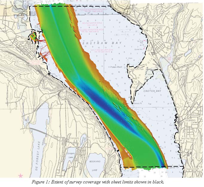
Federal
H12873: NOS Hydrographic Survey , 2016-08-31
National Oceanic and Atmospheric Administration, Department of Commerce —
The National Oceanic and Atmospheric Administration (NOAA) has the statutory mandate to collect hydrographic data in support of nautical chart compilation for safe... -
Federal
NY/NJ Metro Area, Hudson River, and South Long Island 2016 BENTHIC Polygons
National Oceanic and Atmospheric Administration, Department of Commerce —
This data set contains sensitive biological resource data for marine and estuarine bivalve reefs and submerged aquatic vegetation (SAV) in the New York/New Jersey... -
Federal
H13023: NOS Hydrographic Survey , 2017-08-09
National Oceanic and Atmospheric Administration, Department of Commerce —
The National Oceanic and Atmospheric Administration (NOAA) has the statutory mandate to collect hydrographic data in support of nautical chart compilation for safe... -
Federal
Sustainable Shorelines for New York's Hudson River - NERRS/NSC(NERRS Science Collaborative)
National Oceanic and Atmospheric Administration, Department of Commerce —
Several reserves collaborated to develop the Climate Change Vulnerability Assessment Tool for Coastal Habitats. The tool helps decision makers evaluate a habitatâs... -
Federal
Sensitivity of Coastal Environments and Wildlife to Spilled Oil: Hudson River: INVERT (Invertebrate Polygons)
National Oceanic and Atmospheric Administration, Department of Commerce —
This data set contains sensitive biological resource data for marine and estuarine invertebrate species for the Hudson River. Vector polygons in this data set... -
Federal
Sensitivity of Coastal Environments and Wildlife to Spilled Oil: Hudson River: ESI (Environmental Sensitivity Index Shoreline Types - Lines and Polygons)
National Oceanic and Atmospheric Administration, Department of Commerce —
This data set contains vector lines and polygons representing the shoreline and coastal habitats for the Hudson River, classified according to the Environmental... -
Federal
Sensitivity of Coastal Environments and Wildlife to Spilled Oil: Hudson River: RVRMILES (River Mile Marker Lines)
National Oceanic and Atmospheric Administration, Department of Commerce —
This data set contains human-use resource data for river miles along the Hudson River. Vector lines in this data set represent river mile markers. This data set... -
Federal
Sensitivity of Coastal Environments and Wildlife to Spilled Oil: Hudson River: REPTILES (Reptile Polygons)
National Oceanic and Atmospheric Administration, Department of Commerce —
This data set contains sensitive biological resource data for estuarine reptiles (turtles, terrapins) and amphibians (salamanders, frogs) for the Hudson River. Vector... -
Federal
F00861: NOS Hydrographic Survey , 2023-04-07
National Oceanic and Atmospheric Administration, Department of Commerce —
The National Oceanic and Atmospheric Administration (NOAA) has the statutory mandate to collect hydrographic data in support of nautical chart compilation for safe... -
Federal
NY/NJ Metro Area, Hudson River, and South Long Island 2016 FISH Polygons
National Oceanic and Atmospheric Administration, Department of Commerce —
This data set contains sensitive biological resource data for marine, estuarine, anadromous, and freshwater fish species in the New York/New Jersey Metro Area, Hudson... -
Federal
H13092: NOS Hydrographic Survey , 2017-11-09
National Oceanic and Atmospheric Administration, Department of Commerce —
The National Oceanic and Atmospheric Administration (NOAA) has the statutory mandate to collect hydrographic data in support of nautical chart compilation for safe... -
Federal
Sensitivity of Coastal Environments and Wildlife to Spilled Oil: Hudson River: HABITATS (Habitat Polygons)
National Oceanic and Atmospheric Administration, Department of Commerce —
This data set contains sensitive biological resource data for submerged aquatic vegetation (SAV), floating aquatic vegetation (FAV), and rare/sensitive coastal plants...

Official websites use .gov
A
.gov website belongs to an official government
organization in the United States.
Secure .gov websites use HTTPS
A
lock (
) or https:// means you’ve safely connected to
the .gov website. Share sensitive information only on official,
secure websites.