
-
Federal
Sentinel-5P TROPOMI SNPP VIIRS cloud product band 3 (UVIS detector) 1-Orbit L2 7km x 3.5km V1 (S5P_L2__NP_BD3) at GES DISC
National Aeronautics and Space Administration —
Starting from August 6th in 2019, Sentinel-5P TROPOMI along-track high spatial resolution (~5.5km at nadir) has been implemented. For data after August 6th of 2019,... -
Federal
Data for "Updated in-cloud secondary aerosol production in the Northern Hemisphere predicted by the Community Multiscale Air Quality modeling system"
U.S. Environmental Protection Agency —
Data and CMAQ code associated with manuscript, "Updated in-cloud secondary aerosol production in the Northern Hemisphere predicted by the Community Multiscale Air... -
Federal
Sounder SIPS: Suomi NPP CrIMSS Level 3 Specific Quality Control Gridded Daily CLIMCAPS Full Spectral Resolution V2 at GES DISC
National Aeronautics and Space Administration —
WARNING: To users of the derived product “co_mmr_midtrop” (carbon monoxide mass mixing ratio to dry air [kg/kg] at ~500 hPa). This variable has a significant bias due... -
Federal
AERONET-SDA Retrievals
National Aeronautics and Space Administration —
The SDA dataset uses the spectral behavior of AOD to partition between fine and coarse modes, without a size-cutoff radius of the type used by the Dubovik and King... -
Federal
SatCORPS CERES GEO Edition 4 GOES-13 Southern Hemisphere Version 1.0
National Aeronautics and Space Administration —
CER_GEO_Ed4_GOE13_SH_V01 is the Satellite Cloud and Radiation Property retrieval System (SatCORPS) Clouds and the Earth's Radiant Energy System (CERES) Geostationary... -
Federal
GOES-R PLT Cloud Physics LiDAR (CPL) V1
National Aeronautics and Space Administration —
The GOES-R PLT Cloud Physics Lidar (CPL) dataset consists of backscatter coefficient, lidar depolarization ratio, layer top/base height, layer type, particulate... -
Federal
AIRS/Aqua L2 Near Real Time (NRT) Support Retrieval (AIRS-only) V006 (AIRS2SUP_NRT) at GES DISC
National Aeronautics and Space Administration —
The Atmospheric Infrared Sounder (AIRS) Level 2 Near Real Time (NRT) Support Retrieval (AIRS-only) product (AIRS2SUP_NRT_006) differs from the routine product... -
Federal
NOAA Climate Data Records (CDR) of AMSU-A/B and MHS Hydrological Properties, Version 1
National Oceanic and Atmospheric Administration, Department of Commerce —
The NOAA Hydrological Properties for Applications Thematic Climate Data Record (TCDR) consist of Advanced Microwave Sounding Unit-A (AMSU-A), Advanced Microwave... -
Federal
SSMI(S) Hydrological Products
National Oceanic and Atmospheric Administration, Department of Commerce —
The Special Sensor Microwave/Imager (SSM/I) and Special Sensor Microwave Imager-Sounder (SSMIS) have been making measurements of earth-emitted microwave radiation for... -
Federal
NOAA GOES-R Series Advanced Baseline Imager (ABI) Level 2 Cloud Top Phase (ACTP)
National Oceanic and Atmospheric Administration, Department of Commerce —
The Advanced Baseline Imager (ABI) Cloud Top Phase product contains an image with pixel values identifying the presence of cloud in four phase categories. The... -
Federal
GOES-R Surface and Insolation Products
National Oceanic and Atmospheric Administration, Department of Commerce —
GOES Surface and Insolation Products - The GOES Surface and Insolation Products (GSIP) is a high spatial resolution (1/8 x 1/8 degrees) solar radiation product... -
Federal
Operational Linescan System (OLS) - Derived Products (including posters and slides)
National Oceanic and Atmospheric Administration, Department of Commerce —
Visible and thermal infrared imagery from DMSP Operational Linescan System (OLS) instruments are used to monitor the global distribution of clouds and cloud top... -
Federal
NCEP North American Regional Reanalysis (NARR), for 1979 to Present
National Oceanic and Atmospheric Administration, Department of Commerce —
The North America Regional Reanalysis (NARR) Project is a reanalysis of historical observations using a 32-km version of the National Centers for Environmental... -
Federal
GLAS/ICESat L2 Global Thin Cloud/Aerosol Optical Depths Data (HDF5) V033
National Aeronautics and Space Administration —
GLAH11 Level-2 thin cloud/aerosol optical depths data contain thin cloud and aerosol optical depths. A thin cloud is one that does not completely attenuate the lidar... -
Federal
National Weather Service Raw Upper Air Observational Data - Individual Flights
National Oceanic and Atmospheric Administration, Department of Commerce —
These National Weather Service (NWS) raw upper air data contain individual flight data from sites monthly. Majority are Radiosonde Replacement System (RRS) sites,... -
Federal
SWOT Level 2 Radiometer Brightness Temperatures and Troposphere Interim Data Product Version 1.0
National Aeronautics and Space Administration —
The SWOT Level 2 Radiometer Brightness Temperatures and Troposphere Interim Geophysical Data Record (IGDR) Version 1.0 dataset produced by the Surface Water and Ocean... -
Federal
MODIS/Aqua Clouds 1km and 5km 5-Min L2 Wide Swath Subset along CloudSat V002 (MAC06S1) at GES DISC NGDA
National Aeronautics and Space Administration —
This is the wide-swath MODIS/Aqua subset along CloudSat field of view track. The goal of the wide-swath subset is to select and return MODIS data that are within... -
Federal
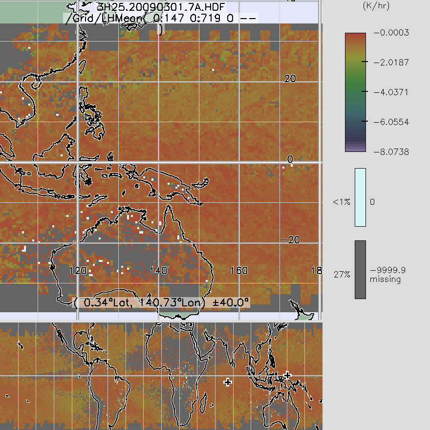
TRMM Precipitation Radar Spectral Latent Heating L3 1 month 0.5 degree x 0.5 degree V7 (TRMM_3H25) at GES DISC
National Aeronautics and Space Administration —
3H25, "Monthly Spectral Latent Heating", produces 0.5 degree x 0.5 degree latent heating, Q1-QR, and Q2 profiles from PR rain -
Federal
Cloudmask, CLAVR-1, NOAA POES AVHRR, 0.0125 degrees, West US, 2007-present, Daytime (Single Scan)
National Oceanic and Atmospheric Administration, Department of Commerce —
The CLAVR-1 cloudmask (Stowe, 1999) is used to cloudmask AVHRR high resolution sea surface temperature products. The cloudmask runs a series of tests on each surface... -
Federal
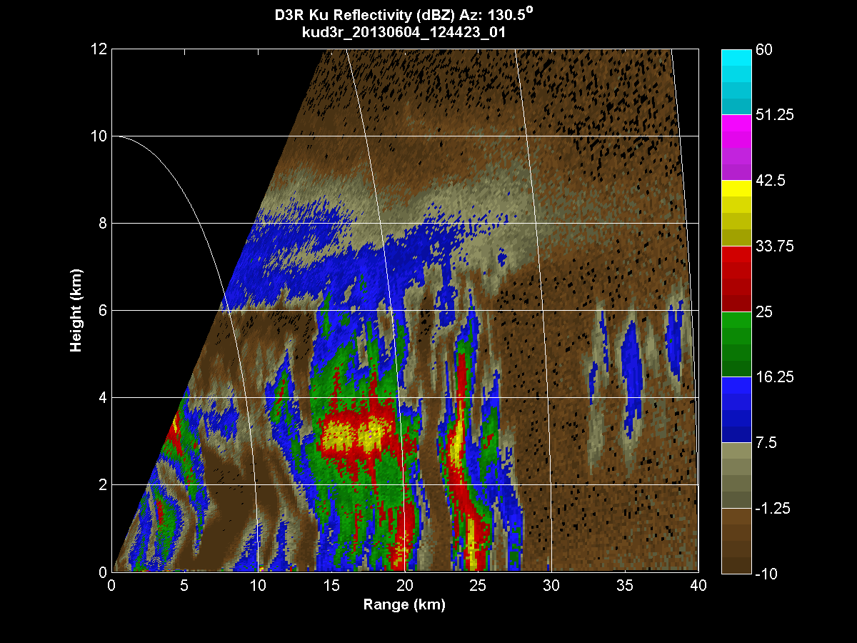
GPM GROUND VALIDATION DUAL-FREQUENCY DUAL-POLARIZED DOPPLER RADAR (D3R) IFLOODS V1
National Aeronautics and Space Administration —
The GPM Ground Validation Dual-frequency Dual-polarized Doppler Radar (D3R) IFloodS dataset contains radar reflectivity and doppler velocity measurements from the...

Official websites use .gov
A
.gov website belongs to an official government
organization in the United States.
Secure .gov websites use HTTPS
A
lock (
) or https:// means you’ve safely connected to
the .gov website. Share sensitive information only on official,
secure websites.