
-
Federal
National Benthic Infaunal Database (NBID)
National Oceanic and Atmospheric Administration, Department of Commerce —
The NBID is a quantitative database on abundances of individual benthic species by sample and study region, along with other synoptically measured environmental... -
Federal
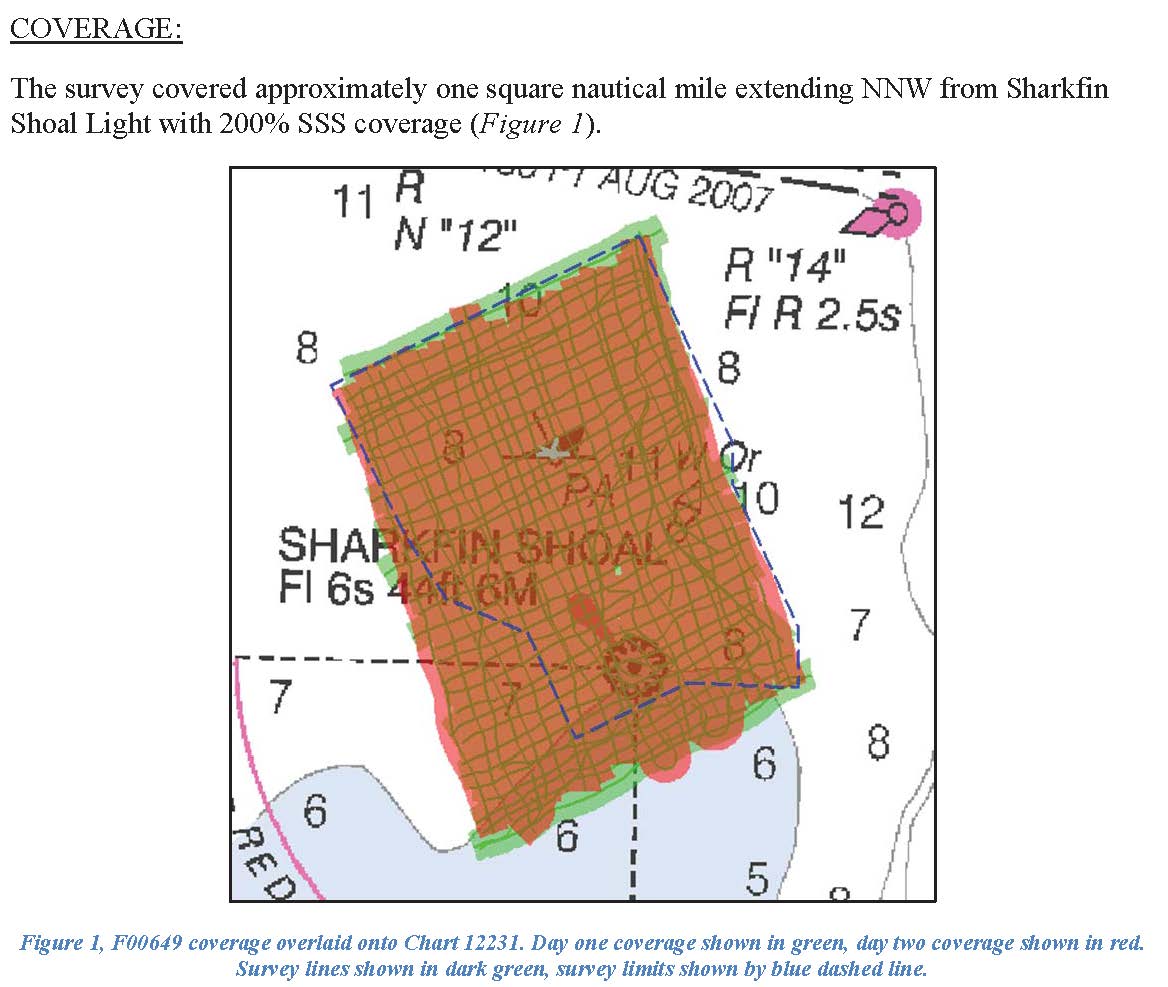
F00649: NOS Hydrographic Survey , 2014-10-17
National Oceanic and Atmospheric Administration, Department of Commerce —
The National Oceanic and Atmospheric Administration (NOAA) has the statutory mandate to collect hydrographic data in support of nautical chart compilation for safe... -
Federal
2004 Benthic Grab Data for Catlett and Goodwin Islands on the York River in Chesapeake Bay, Virginia (Ches_2004benthos)
National Oceanic and Atmospheric Administration, Department of Commerce —
This data set represents the benthic community information gathered from grab sampling in 2004 (12 stations). In Fall/Winter 2002, researchers from the Virginia... -
Federal
National Status and Trends, Benthic Surveillance Project Sites, 1984-1992, National Centers for Coastal Ocean Science
National Oceanic and Atmospheric Administration, Department of Commerce —
This data set reports information regarding the nominal sampling locations for the National Status and Trends Benthic Surveillance Project sites. One record is... -
Federal
Okeanos Explorer (EX1404L2): Our Deepwater Backyard: Exploring the Atlantic Canyons and Seamounts
National Oceanic and Atmospheric Administration, Department of Commerce —
High resolution mapping data from vessel multibeam and submersible sonar systems; singlebeam and sub-bottom profile data; periodic CTD casts; submersible CTD data;... -
Federal
Shoreline Mapping Program of CHESAPEAKE BAY, RHODE RIVER TO KENWOOD BEACH, MD, MD0502A NGDA
National Oceanic and Atmospheric Administration, Department of Commerce —
These data provide an accurate high-resolution shoreline compiled from imagery of CHESAPEAKE BAY, RHODE RIVER TO KENWOOD BEACH, MD . This vector shoreline data is... -
Federal
Coastal Mapping Program of Chesapeake Bay, Deep Creek to Pungoteague Creek, VA, VA1802B-TB-N NGDA
National Oceanic and Atmospheric Administration, Department of Commerce —
These data provide an accurate high-resolution shoreline compiled from imagery of Chesapeake Bay, Deep Creek to Pungoteague Creek, VA . This vector shoreline data is... -
Federal
H12857: NOS Hydrographic Survey , 2017-01-03
National Oceanic and Atmospheric Administration, Department of Commerce —
The National Oceanic and Atmospheric Administration (NOAA) has the statutory mandate to collect hydrographic data in support of nautical chart compilation for safe... -
Federal
NCCOS Assessment: Orthoimagery, vegetation, and sediment characteristics in Susquehanna River, Chesapeake Bay on 20230516 (NCEI Accession 0303869)
National Oceanic and Atmospheric Administration, Department of Commerce —
This dataset contains imagery, GPS coordinates, elevation data, types of vegetation, and sediment characteristics collected from Fishing Battery Island. This island... -
Federal
H12039: NOS Hydrographic Survey , Approaches to Cheasapeake Bay, Virginia, 2009-07-21
National Oceanic and Atmospheric Administration, Department of Commerce —
The National Oceanic and Atmospheric Administration (NOAA) has the statutory mandate to collect hydrographic data in support of nautical chart compilation for safe... -
Federal
National Status and Trends, Benthic Surveillance Project Fluorescent Aromatic Compounds (FAC) Data, 1984-1991, National Centers for Coastal Ocean Science
National Oceanic and Atmospheric Administration, Department of Commerce —
The National Status and Trends (NSandT) Benthic Surveillance Fluorescent Aromatic Compounds (FAC) file reports the trace concentrations of Fluorescent Aromatic... -
Federal
NOAA/WDS Paleoclimatology - Cronin et al. 2007 Chesapeake Bay 8.2k Sea Level Rise Data
National Oceanic and Atmospheric Administration, Department of Commerce —
This archived Paleoclimatology Study is available from the NOAA National Centers for Environmental Information (NCEI), under the World Data Service (WDS) for... -
Federal
USEPA Environmental Quality Index (EQI) - Air, Water, Land, Built, and Sociodemographic Domains Transformed Variables Dataset as Input for the 2006-2010 USEPA EQI, by County for the United States
U.S. Environmental Protection Agency —
The US Environmental Protection Agency's (EPA) Center for Public Health and Environmental Assessment (CPHEA) in Public Health and Environmental Systems Division... -
Federal
2002 Benthic Grab Data for Catlett and Goodwin Islands on the York River in Chesapeake Bay, Virginia (Ches_2002benthos)
National Oceanic and Atmospheric Administration, Department of Commerce —
This data set represents the benthic community information gathered from grab sampling in 2002 (56 stations).In Fall/Winter 2002, researchers from the Virginia... -
Federal
Chesapeake Bay and the Outer Coasts of Maryland and Virginia 2016 ESI TERRESTRIAL MAMMAL Polygons
National Oceanic and Atmospheric Administration, Department of Commerce —
This data set contains sensitive biological resource data for rare, threatened, and endangered terrestrial mammal species in Chesapeake Bay and the Outer Coasts of... -
Federal
NCCOS Assessment: Coastal Ecosystem Assessment of Chesapeake Bay Watersheds, Land Use Patterns and River Conditions from 2007-04-30 to 2012-09-27 (NCEI Accession 0303961)
National Oceanic and Atmospheric Administration, Department of Commerce —
This data collection comprises six years of estuarine monitoring for an assessment of coastal ecosystem health in relationship to watershed characteristics,... -
Federal
Dissolved inorganic carbon (DIC), total alkalinity (TA), temperature, salinity, dissolved oxygen and other parameters collected from discrete samples and profile observations during R/V Rachel Carson cruises 201605CB, 201606CB, 201608CB, 201610CB (EXPOCODEs 32RC20160504, 32RC20160606, 32RC20160808, 32RC20161010) in the Chesapeake Bay and North Atlantic Ocean from 2016-05-04 to 2016-10-13 (NCEI Accession 0209358)
National Oceanic and Atmospheric Administration, Department of Commerce —
This dataset includes discrete profile data collected during the R/V Rachel Carson cruises 201605CB, 201606CB, 201608CB, 201610CB (EXPOCODEs 32RC20160504,... -
Federal
US EPA Nonattainment Areas and Designations-SO2 (2010 NAAQS)
U.S. Environmental Protection Agency —
This web service contains the following layer: SO2 2010 NAAQS State Level. Full FGDC metadata records for each layer may be found by clicking the layer name at the... -
Federal
H13686: NOS Hydrographic Survey , 2023-03-27
National Oceanic and Atmospheric Administration, Department of Commerce —
The National Oceanic and Atmospheric Administration (NOAA) has the statutory mandate to collect hydrographic data in support of nautical chart compilation for safe... -
Federal
F00412: NOS Hydrographic Survey , Southern Chesapeake Bay Item Investigations, Virginia, 1995-05-24
National Oceanic and Atmospheric Administration, Department of Commerce —
The National Oceanic and Atmospheric Administration (NOAA) has the statutory mandate to collect hydrographic data in support of nautical chart compilation for safe...

Official websites use .gov
A
.gov website belongs to an official government
organization in the United States.
Secure .gov websites use HTTPS
A
lock (
) or https:// means you’ve safely connected to
the .gov website. Share sensitive information only on official,
secure websites.
.jpg)
.jpg)