
-
Federal
Multibeam collection for AT39-02C: Multibeam data collected aboard Atlantis from 21-Dec-17 to 28-Dec-17, Mar Del Plata, Argentina to Comodoro Rivadavia, Argentina
National Oceanic and Atmospheric Administration, Department of Commerce —
This data set is part of a larger set of data called the Multibeam Bathymetry Database (MBBDB) where other similar data can be found -
Federal
NOAA TIFF Image - 8m Backscatter Mosaic, W00221-222 USVI 2012, Seafloor Characterization of the US Caribbean - Nancy Foster - M-I907-NF-12 (2012), UTM 20N NAD83 (NCEI Accession 0131856)
National Oceanic and Atmospheric Administration, Department of Commerce —
This image represents a 8 meter resolution backscatter mosaic of of a sharply sloping swath of the St. John Shelf, south of NE Reserve, offshore of Fajardo, Puerto... -
Federal
H10941: NOS Hydrographic Survey , Gulf of Mexico, Texas, 2000-02-08
National Oceanic and Atmospheric Administration, Department of Commerce —
The National Oceanic and Atmospheric Administration (NOAA) has the statutory mandate to collect hydrographic data in support of nautical chart compilation for safe... -
Federal
H11469: NOS Hydrographic Survey , Cape Decision, Alaska, 2005-05-31
National Oceanic and Atmospheric Administration, Department of Commerce —
The National Oceanic and Atmospheric Administration (NOAA) has the statutory mandate to collect hydrographic data in support of nautical chart compilation for safe... -
Federal
H12292: NOS Hydrographic Survey , West of Prince of Wales Island, Alaska, 2011-10-16
National Oceanic and Atmospheric Administration, Department of Commerce —
The National Oceanic and Atmospheric Administration (NOAA) has the statutory mandate to collect hydrographic data in support of nautical chart compilation for safe... -
Federal
H13946: NOS Hydrographic Survey , 2024-10-18
National Oceanic and Atmospheric Administration, Department of Commerce —
The National Oceanic and Atmospheric Administration (NOAA) has the statutory mandate to collect hydrographic data in support of nautical chart compilation for safe... -
Federal
Color Shaded-Relief GeoTIFF Image Showing the Combined 4-m Multibeam Bathymetry Generated from National Oceanic and Atmospheric Administration (NOAA) Surveys H11922, H11995, H11996, H12009, H12010, H12011, H12015, H12023, H12033, H12137, H12139, H12296, H12298, and H12299 Offshore in Rhode Island and Block Island Sounds (RICOMB_4MMB_UTM19.TIF, UTM Zone 19, NAD 83)
Department of the Interior —
Detailed bathymetric maps of the sea floor in Block Island and Rhode Island Sounds are of great interest to the New York, Rhode Island, and Massachusetts research and... -
Federal
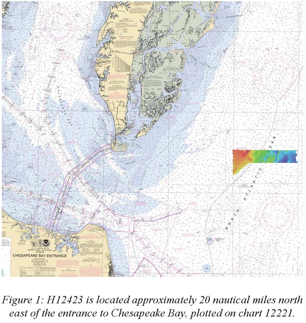
H12423: NOS Hydrographic Survey , Approaches to Chesapeake Bay, Virginia, 2012-09-09
National Oceanic and Atmospheric Administration, Department of Commerce —
The National Oceanic and Atmospheric Administration (NOAA) has the statutory mandate to collect hydrographic data in support of nautical chart compilation for safe... -
Federal
H10349: NOS Hydrographic Survey , Western Long Island Sound, New York and Connecticut, 1990-08-03
National Oceanic and Atmospheric Administration, Department of Commerce —
The National Oceanic and Atmospheric Administration (NOAA) has the statutory mandate to collect hydrographic data in support of nautical chart compilation for safe... -
Federal
H11292: NOS Hydrographic Survey , Lake Washington, Washington, 2004-10-27
National Oceanic and Atmospheric Administration, Department of Commerce —
The National Oceanic and Atmospheric Administration (NOAA) has the statutory mandate to collect hydrographic data in support of nautical chart compilation for safe... -
Federal
Multibeam collection for KN159L5: Multibeam data collected aboard Knorr from 06-Oct-98 to 04-Nov-98, Rio de Janeiro, Brazil to Rio de Janeiro, Brazil
National Oceanic and Atmospheric Administration, Department of Commerce —
This data set is part of a larger set of data called the Multibeam Bathymetry Database (MBBDB) where other similar data can be found -
Federal
H13339: NOS Hydrographic Survey , 2019-09-22
National Oceanic and Atmospheric Administration, Department of Commerce —
The National Oceanic and Atmospheric Administration (NOAA) has the statutory mandate to collect hydrographic data in support of nautical chart compilation for safe... -
Federal
NOAA TIFF Image - NF12_PR_1002_bathy_8m.tif - Benthic Habitat Characterization - NOAA Ship Nancy Foster - M-I907-NF-12 (2012), UTM 20N NAD83 (NCEI Accession 0131856)
National Oceanic and Atmospheric Administration, Department of Commerce —
This image represents a 4 meter resolution bathymetry of a reef shelf/bank and the steep canyons and slopes of the NE Reserve, offshore of Fajardo, Puerto Rico. The... -
Federal
F00666: NOS Hydrographic Survey , 2015-08-23
National Oceanic and Atmospheric Administration, Department of Commerce —
The National Oceanic and Atmospheric Administration (NOAA) has the statutory mandate to collect hydrographic data in support of nautical chart compilation for safe... -
Federal
H10962: NOS Hydrographic Survey , San Francisco, California, 2000-08-13
National Oceanic and Atmospheric Administration, Department of Commerce —
The National Oceanic and Atmospheric Administration (NOAA) has the statutory mandate to collect hydrographic data in support of nautical chart compilation for safe... -
Federal
EX1302: Ship Shakedown, Patch Test and Exploration, NE Canyons and Seamounts on NOAA Ship Okeanos Explorer between 20130513 and 20130606
National Oceanic and Atmospheric Administration, Department of Commerce —
Between May 13 and May 18, shakedown operations will: ensure all scientific sonars are in good working order after dry dock operations; assess noise reduction... -
Federal
H12172: NOS Hydrographic Survey , U.S. Virgin Islands Mapping Project, 2010-04-05
National Oceanic and Atmospheric Administration, Department of Commerce —
The National Oceanic and Atmospheric Administration (NOAA) has the statutory mandate to collect hydrographic data in support of nautical chart compilation for safe... -
Federal
H11208E: NOS Hydrographic Survey , Gulf of Esquibel and Cape Decision, Alaska, 2004-08-24
National Oceanic and Atmospheric Administration, Department of Commerce —
The National Oceanic and Atmospheric Administration (NOAA) has the statutory mandate to collect hydrographic data in support of nautical chart compilation for safe... -
Federal
F00477A: NOS Hydrographic Survey , Port of San Francisco and Vicinity, California, 2001-10-26
National Oceanic and Atmospheric Administration, Department of Commerce —
The National Oceanic and Atmospheric Administration (NOAA) has the statutory mandate to collect hydrographic data in support of nautical chart compilation for safe... -
Federal
Exploring Alaska's Seamounts on RV Atlantis in North Pacific Ocean and Gulf of Alaska between 20040730 and 20040823
National Oceanic and Atmospheric Administration, Department of Commerce —
Five seamounts (Denson, Dickins, Pratt, Welker and Giacomini) in the Gulf of Alaska that had not previously been observed by manned submersible or ROV were thoroughly...

Official websites use .gov
A
.gov website belongs to an official government
organization in the United States.
Secure .gov websites use HTTPS
A
lock (
) or https:// means you’ve safely connected to
the .gov website. Share sensitive information only on official,
secure websites.
.jpg)
.jpg)
.jpg)
.jpg)