
-
Federal
H11330: NOS Hydrographic Survey , Shumagin Islands, Alaska, 2004-07-26
National Oceanic and Atmospheric Administration, Department of Commerce —
The National Oceanic and Atmospheric Administration (NOAA) has the statutory mandate to collect hydrographic data in support of nautical chart compilation for safe... -
Federal
Multibeam collection for KN191: Multibeam data collected aboard Knorr from 28-Aug-07 to 14-Sep-07, Woods Hole, Massachusetts to Woods Hole, Massachusetts
National Oceanic and Atmospheric Administration, Department of Commerce —
This data set is part of a larger set of data called the Multibeam Bathymetry Database (MBBDB) where other similar data can be found -
Federal
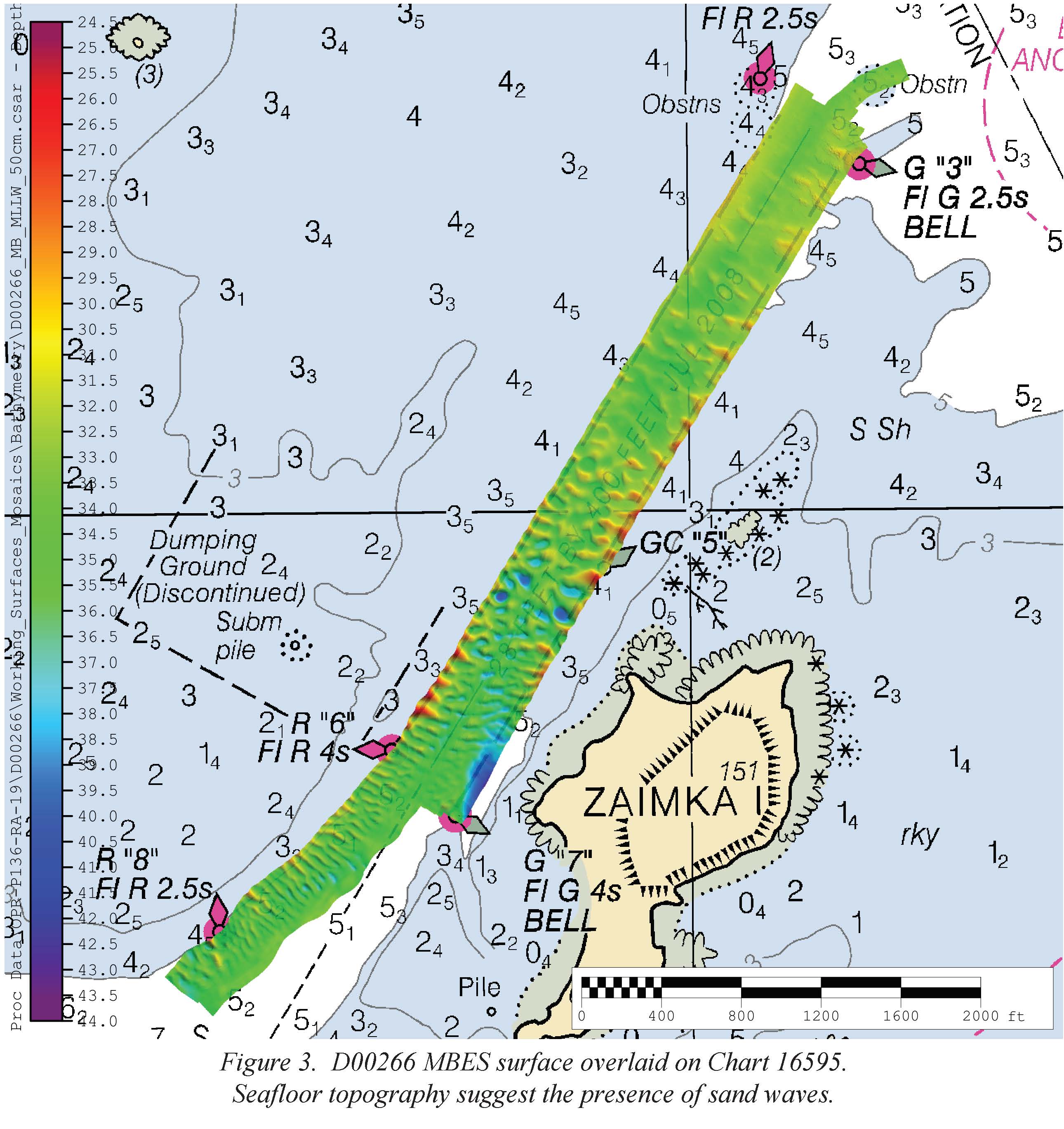
D00266: NOS Hydrographic Survey , 2019-05-20
National Oceanic and Atmospheric Administration, Department of Commerce —
The National Oceanic and Atmospheric Administration (NOAA) has the statutory mandate to collect hydrographic data in support of nautical chart compilation for safe... -
Federal
F00833: NOS Hydrographic Survey , 2021-07-20
National Oceanic and Atmospheric Administration, Department of Commerce —
The National Oceanic and Atmospheric Administration (NOAA) has the statutory mandate to collect hydrographic data in support of nautical chart compilation for safe... -
Federal
Multibeam collection for KM0712: Multibeam data collected aboard Kilo Moana from 23-Jul-07 to 27-Jul-07, Honolulu, Hawaii to Honolulu, Hawaii
National Oceanic and Atmospheric Administration, Department of Commerce —
This data set is part of a larger set of data called the Multibeam Bathymetry Database (MBBDB) where other similar data can be found -
Federal
NOAA TIFF Image - 3m Bathymetry Mosaic, Florida Deep Coral Areas - Lost Coast Explorer - (2010), UTM 17N NAD83
National Oceanic and Atmospheric Administration, Department of Commerce —
This dataset contains a unified GeoTiff with 3x3 meter cell size representing bathymetry of several deep coral priority areas off the Atlantic Coast of Florida,... -
Federal
F00887: NOS Hydrographic Survey , 2025-02-05
National Oceanic and Atmospheric Administration, Department of Commerce —
The National Oceanic and Atmospheric Administration (NOAA) has the statutory mandate to collect hydrographic data in support of nautical chart compilation for safe... -
Federal
H10778: NOS Hydrographic Survey , Prince William Sound, Alaska, 1997-10-28
National Oceanic and Atmospheric Administration, Department of Commerce —
The National Oceanic and Atmospheric Administration (NOAA) has the statutory mandate to collect hydrographic data in support of nautical chart compilation for safe... -
Federal
H11676: NOS Hydrographic Survey , Shumagin Islands, Alaska, 2007-08-16
National Oceanic and Atmospheric Administration, Department of Commerce —
The National Oceanic and Atmospheric Administration (NOAA) has the statutory mandate to collect hydrographic data in support of nautical chart compilation for safe... -
Federal
H11919: NOS Hydrographic Survey , Humboldt Bay, California, 2008-08-27
National Oceanic and Atmospheric Administration, Department of Commerce —
The National Oceanic and Atmospheric Administration (NOAA) has the statutory mandate to collect hydrographic data in support of nautical chart compilation for safe... -
Federal
H11307: NOS Hydrographic Survey , Mobile Bay, Alabama, 2007-10-25
National Oceanic and Atmospheric Administration, Department of Commerce —
The National Oceanic and Atmospheric Administration (NOAA) has the statutory mandate to collect hydrographic data in support of nautical chart compilation for safe... -
Federal
H11982: NOS Hydrographic Survey , California Coastal Mapping Program, California, 2009-06-05
National Oceanic and Atmospheric Administration, Department of Commerce —
The National Oceanic and Atmospheric Administration (NOAA) has the statutory mandate to collect hydrographic data in support of nautical chart compilation for safe... -
Federal
Seafloor Bathymetry Image of South of Santa Rosa Island, Channel Islands National Marine Sanctuary (8m resolution tif)
National Oceanic and Atmospheric Administration, Department of Commerce —
This image represents an 8 meter resolution bathymetry of the seafloor south of Santa Rosa Island in Channel Islands National Marine Sanctuary. It was acquired using... -
Federal
F00547: NOS Hydrographic Survey , Elizabeth River Investigation, Virginia, 2007-08-06
National Oceanic and Atmospheric Administration, Department of Commerce —
The National Oceanic and Atmospheric Administration (NOAA) has the statutory mandate to collect hydrographic data in support of nautical chart compilation for safe... -
Federal
H11600: NOS Hydrographic Survey , New York Harbor and Approaches, New York and New Jersey, 2006-10-09
National Oceanic and Atmospheric Administration, Department of Commerce —
The National Oceanic and Atmospheric Administration (NOAA) has the statutory mandate to collect hydrographic data in support of nautical chart compilation for safe... -
Federal
Multibeam collection for REVT03RR: Multibeam data collected aboard Roger Revelle from 18-Nov-96 to 20-Nov-96, San Diego, California to San Diego, California
National Oceanic and Atmospheric Administration, Department of Commerce —
This data set is part of a larger set of data called the Multibeam Bathymetry Database (MBBDB) where other similar data can be found -
Federal
H10562: NOS Hydrographic Survey , Southwest Texas Coast, Texas, 1994-09-20
National Oceanic and Atmospheric Administration, Department of Commerce —
The National Oceanic and Atmospheric Administration (NOAA) has the statutory mandate to collect hydrographic data in support of nautical chart compilation for safe... -
Federal
Multibeam collection for HB1901L2: Multibeam data collected aboard NOAA Ship HENRY B. BIGELOW (R225) from 26-Mar-19 to 05-Apr-19, Newport, Rhode Island to Newport, RI
National Oceanic and Atmospheric Administration, Department of Commerce —
This data set is part of a larger set of data called the Multibeam Bathymetry Database (MBBDB) where other similar data can be found -
Federal
NOS ESRI Grid Unified 10m Multibeam Bathymetry La Parguera, Puerto Rico, St Croix, St. John and St. Thomas, 2004-2006: Projects NF-04-06, NF-05-05 and NF-06-03, UTM 20N NAD83
National Oceanic and Atmospheric Administration, Department of Commerce —
This dataset contains a unified ESRI Grid with 10 meter cell size representing the bathymetry of selected portions of seafloor around La Parguera, P.R. and St. Croix,... -
Federal
H13586: NOS Hydrographic Survey , 2022-08-23
National Oceanic and Atmospheric Administration, Department of Commerce —
The National Oceanic and Atmospheric Administration (NOAA) has the statutory mandate to collect hydrographic data in support of nautical chart compilation for safe...

Official websites use .gov
A
.gov website belongs to an official government
organization in the United States.
Secure .gov websites use HTTPS
A
lock (
) or https:// means you’ve safely connected to
the .gov website. Share sensitive information only on official,
secure websites.
.jpg)
.jpg)
.jpg)
.jpg)