
-
Federal
NOAA ESRI Geotiff- 2m Multibeam Backscatter of NPS's Salt River Bay National Historical Park and Ecological Reserve, St. Croix, US Virgin Islands, Project NF-05-05, 2005, UTM 20 NAD83
National Oceanic and Atmospheric Administration, Department of Commerce —
This image represents a 2 meter resolution backscatter mosaic of the north shore (Salt River) of St. Croix, US Virgin Islands. NOAA's NOS/NCCOS/CCMA Biogeography... -
Federal
Multibeam collection for KM0723: Multibeam data collected aboard Kilo Moana from 06-Dec-07 to 18-Dec-07, Honolulu, Hawaii to Honolulu, Hawaii
National Oceanic and Atmospheric Administration, Department of Commerce —
This data set is part of a larger set of data called the Multibeam Bathymetry Database (MBBDB) where other similar data can be found -
Federal
H12736: NOS Hydrographic Survey , 2015-07-28
National Oceanic and Atmospheric Administration, Department of Commerce —
The National Oceanic and Atmospheric Administration (NOAA) has the statutory mandate to collect hydrographic data in support of nautical chart compilation for safe... -
Federal
H13913: NOS Hydrographic Survey , 2024-10-09
National Oceanic and Atmospheric Administration, Department of Commerce —
The National Oceanic and Atmospheric Administration (NOAA) has the statutory mandate to collect hydrographic data in support of nautical chart compilation for safe... -
Federal
B00215: NOS Hydrographic Survey , 1990-07-14
National Oceanic and Atmospheric Administration, Department of Commerce —
The National Oceanic and Atmospheric Administration (NOAA) has the statutory mandate to collect hydrographic data in support of nautical chart compilation for safe... -
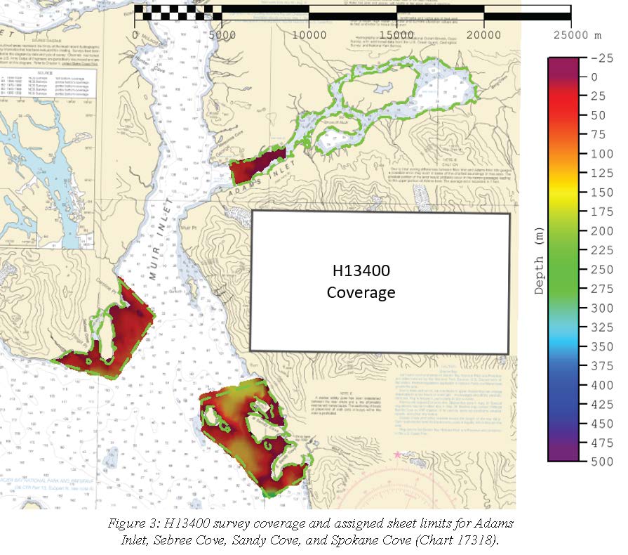
Federal
H13400: NOS Hydrographic Survey , 2021-06-23
National Oceanic and Atmospheric Administration, Department of Commerce —
The National Oceanic and Atmospheric Administration (NOAA) has the statutory mandate to collect hydrographic data in support of nautical chart compilation for safe... -
Federal
Multibeam collection for HLY04TH: Multibeam data collected aboard Healy from 06-Nov-04 to 08-Nov-04, Prince Rupert, Canada to Seattle, Washington
National Oceanic and Atmospheric Administration, Department of Commerce —
This data set is part of a larger set of data called the Multibeam Bathymetry Database (MBBDB) where other similar data can be found -
Federal
W00212: NOS Hydrographic Survey , Outside Source Data Surveys - 2010, 2010-05-20
National Oceanic and Atmospheric Administration, Department of Commerce —
The National Oceanic and Atmospheric Administration (NOAA) has the statutory mandate to collect hydrographic data in support of nautical chart compilation for safe... -
Federal
H12434: NOS Hydrographic Survey , Louisiana Coast, Louisiana, 2012-12-08
National Oceanic and Atmospheric Administration, Department of Commerce —
The National Oceanic and Atmospheric Administration (NOAA) has the statutory mandate to collect hydrographic data in support of nautical chart compilation for safe... -
Federal
H12175: NOS Hydrographic Survey , Behm Canal, Alaska, 2010-05-23
National Oceanic and Atmospheric Administration, Department of Commerce —
The National Oceanic and Atmospheric Administration (NOAA) has the statutory mandate to collect hydrographic data in support of nautical chart compilation for safe... -
Federal
H10678: NOS Hydrographic Survey , Stephens Passage, Alaska, 1996-05-01
National Oceanic and Atmospheric Administration, Department of Commerce —
The National Oceanic and Atmospheric Administration (NOAA) has the statutory mandate to collect hydrographic data in support of nautical chart compilation for safe... -
Federal
H12144: NOS Hydrographic Survey , Northern Glacier Bay, Alaska, 2009-11-03
National Oceanic and Atmospheric Administration, Department of Commerce —
The National Oceanic and Atmospheric Administration (NOAA) has the statutory mandate to collect hydrographic data in support of nautical chart compilation for safe... -
Federal
NOAA TIFF Graphic- 0.5m Backscatter Mosaic of St. Croix (Buck Island), US Virgin Islands, 2004
National Oceanic and Atmospheric Administration, Department of Commerce —
This geotiff represents a 0.5 meter resolution backscatter mosaic of the north shore of Buck Island, St. Croix, US Virgin Islands.NOAA's NOS/NCCOS/CCMA Biogeography... -
Federal
H11534: NOS Hydrographic Survey , Approaches to Cape Canaveral, Florida, 2007-05-05
National Oceanic and Atmospheric Administration, Department of Commerce —
The National Oceanic and Atmospheric Administration (NOAA) has the statutory mandate to collect hydrographic data in support of nautical chart compilation for safe... -
Federal
Multibeam collection for AR47: Multibeam data collected aboard Neil Armstrong from 15-Sep-20 to 21-Oct-20, Woods Hole, Massachusetts to Woods Hole, Massachusetts
National Oceanic and Atmospheric Administration, Department of Commerce —
This data set is part of a larger set of data called the Multibeam Bathymetry Database (MBBDB) where other similar data can be found -
Federal
H12626: NOS Hydrographic Survey , 2014-11-15
National Oceanic and Atmospheric Administration, Department of Commerce —
The National Oceanic and Atmospheric Administration (NOAA) has the statutory mandate to collect hydrographic data in support of nautical chart compilation for safe... -
Federal
W00591: NOS Hydrographic Survey , External Source Data 2021, 2020-10-20
National Oceanic and Atmospheric Administration, Department of Commerce —
The National Oceanic and Atmospheric Administration (NOAA) has the statutory mandate to collect hydrographic data in support of nautical chart compilation for safe... -
Federal
H12130: NOS Hydrographic Survey , Oregon Coast Mapping Project, Oregon, 2009-11-01
National Oceanic and Atmospheric Administration, Department of Commerce —
The National Oceanic and Atmospheric Administration (NOAA) has the statutory mandate to collect hydrographic data in support of nautical chart compilation for safe... -
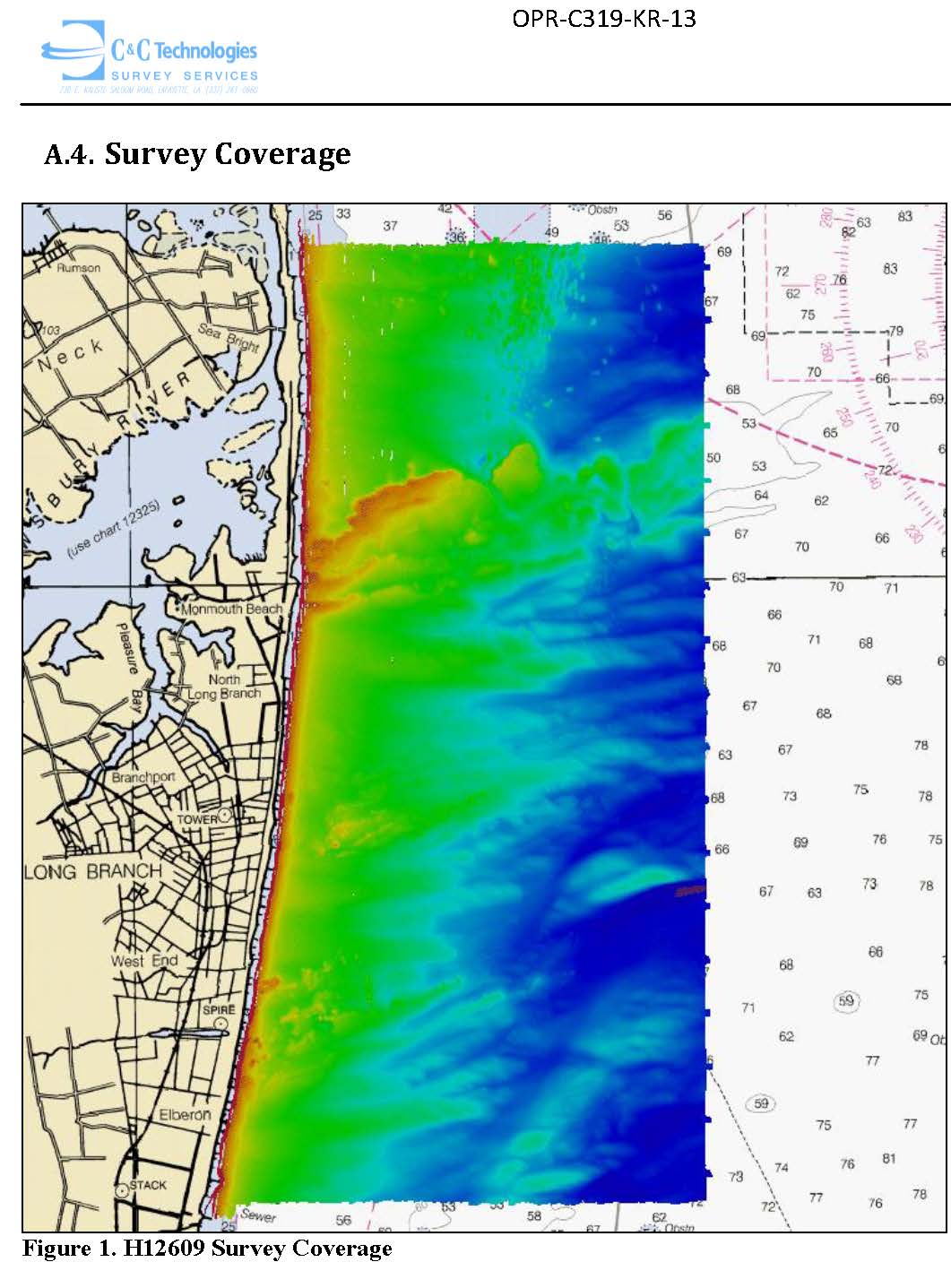
Federal
H12609: NOS Hydrographic Survey , 2015-02-07
National Oceanic and Atmospheric Administration, Department of Commerce —
The National Oceanic and Atmospheric Administration (NOAA) has the statutory mandate to collect hydrographic data in support of nautical chart compilation for safe... -
Federal
W00612: NOS Hydrographic Survey , 1997-03-31
National Oceanic and Atmospheric Administration, Department of Commerce —
The National Oceanic and Atmospheric Administration (NOAA) has the statutory mandate to collect hydrographic data in support of nautical chart compilation for safe...

Official websites use .gov
A
.gov website belongs to an official government
organization in the United States.
Secure .gov websites use HTTPS
A
lock (
) or https:// means you’ve safely connected to
the .gov website. Share sensitive information only on official,
secure websites.
.jpg)
.jpg)
.jpg)
.jpg)