
-
Federal
Walton-Smith CTD, WS21032, WS21032_WS21032_Stn.TB4, 2021-02-05, 27.6225N 83.1343W
National Oceanic and Atmospheric Administration, Department of Commerce —
Walton-Smith Conductivity, Temperature, Depth (CTD) - WS21032 - WS21032_WS21032_Stn.TB4 - 2021-02-05 - 27.6225N 83.1343W. Hydrographic Measurements in the Gulf of... -
Federal
EK60 Water Column Sonar Data Collected During NF-14-08
National Oceanic and Atmospheric Administration, Department of Commerce —
Cruise NF-14-08-MPA (EK60). Not available -
Federal
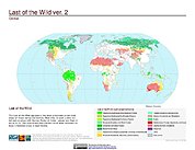
Last of the Wild Project, Version 2, 2005 (LWP-2): Last of the Wild Dataset (Geographic)
National Aeronautics and Space Administration —
The Last of the Wild Dataset of the Last of the Wild Project, Version 2, 2005 (LWP-2) is derived from the LWP-2 Human Footprint Dataset. The gridded data are... -
Federal
Savannah CTD, SAV18173, SAV18173_STA56, 2018-06-24, 25.351N 81.2283W
National Oceanic and Atmospheric Administration, Department of Commerce —
Savannah Conductivity, Temperature, Depth (CTD) - SAV18173 - SAV18173_STA56 - 2018-06-24 - 25.351N 81.2283W. Hydrographic Measurements in the Gulf of Mexico. flags: 1... -
Federal
Sea Surface Temperature (SST) Average Annual Maximum Anomaly, 1985-2018 - American Samoa
National Oceanic and Atmospheric Administration, Department of Commerce —
Sea surface temperature (SST) plays an important role in a number of ecological processes and can vary over a wide range of time scales, from daily to decadal... -
Federal
EM122 Water Column Sonar Data Collected During HLY21TG
National Oceanic and Atmospheric Administration, Department of Commerce —
Transit -
Federal
Walton-Smith CTD, WS1004, WS1004_WS1004_10, 2010-03-09, 24.7868N 80.8615W
National Oceanic and Atmospheric Administration, Department of Commerce —
Walton-Smith Conductivity, Temperature, Depth (CTD) - WS1004 - WS1004_WS1004_10 - 2010-03-09 - 24.7868N 80.8615W. Hydrographic Measurements in the Gulf of Mexico.... -
Federal
Walton-Smith CTD, WS1212, WS1212_034, 2012-08-09, 25.9488N 81.769W
National Oceanic and Atmospheric Administration, Department of Commerce —
Walton-Smith Conductivity, Temperature, Depth (CTD) - WS1212 - WS1212_034 - 2012-08-09 - 25.9488N 81.769W. Hydrographic Measurements in the Gulf of Mexico. flags: 1 =... -
Federal
Walton-Smith CTD, WS21278, WS21278_WS21277 staV5, 2021-10-08, 26.9565N 82.7502W
National Oceanic and Atmospheric Administration, Department of Commerce —
Walton-Smith Conductivity, Temperature, Depth (CTD) - WS21278 - WS21278_WS21277 staV5 - 2021-10-08 - 26.9565N 82.7502W. Hydrographic Measurements in the Gulf of... -
Federal
Dall's porpoise at-sea density off California
National Oceanic and Atmospheric Administration, Department of Commerce —
The National Marine Sanctuary Program (NMSP) updates and revises the management plans for each of its 13 sanctuaries. This process, which is open to the public,... -
Federal
EK80 Water Column Sonar Data Collected During DY2207
National Oceanic and Atmospheric Administration, Department of Commerce —
The Midwater Assessment and Conservation Engineering (MACE) program of NOAA Fisheries, Alaska Fisheries Science Center (AFSC), conducted an acoustic-trawl (AT) stock... -
Federal
Walton-Smith CTD, WS0919, WS0919_WS0919_034, 2009-10-28, 25.9478N 81.7675W
National Oceanic and Atmospheric Administration, Department of Commerce —
Walton-Smith Conductivity, Temperature, Depth (CTD) - WS0919 - WS0919_WS0919_034 - 2009-10-28 - 25.9478N 81.7675W. Hydrographic Measurements in the Gulf of Mexico.... -
Federal
Walton-Smith CTD, WS21212, WS21212_WS21212_StaV3, 2021-08-04, 27.0353N 82.6138W
National Oceanic and Atmospheric Administration, Department of Commerce —
Walton-Smith Conductivity, Temperature, Depth (CTD) - WS21212 - WS21212_WS21212_StaV3 - 2021-08-04 - 27.0353N 82.6138W. Hydrographic Measurements in the Gulf of... -
Federal
Walton-Smith CTD, WS21151, WS21151_WS21151_StnCAL1, 2021-06-02, 26.4258N 81.9602W
National Oceanic and Atmospheric Administration, Department of Commerce —
Walton-Smith Conductivity, Temperature, Depth (CTD) - WS21151 - WS21151_WS21151_StnCAL1 - 2021-06-02 - 26.4258N 81.9602W. Hydrographic Measurements in the Gulf of... -
Federal
Seafloor character--Offshore of Bolinas, California
Department of the Interior —
This part of DS 781 presents the seafloor-character map Offshore of Bolinas, California (raster data file is included in "SeafloorCharacter_OffshoreBolinas.zip,"... -
Federal
Probabilistic Wildfire Risk Flame Length Probability 6 (Image Service)
Department of Agriculture —
National data on burn probability (BP) and conditional flame-length probability (FLP) were generated for the conterminous United States (CONUS), Alaska, and Hawaii... -
Federal
BOEM Conductor Cutting Hermosa Platform Raw Audio
National Oceanic and Atmospheric Administration, Department of Commerce —
These data were collected from March 28 to April 24, 2021, at Platform Hermosa as part of a larger rffort to characterize the sound from mechanical conductor cutting... -
Federal
Towed Array EK80 Water Column Sonar Data Collected During EN727
National Oceanic and Atmospheric Administration, Department of Commerce —
The Northeast U.S. Shelf Long-Term Ecological Research program (NES-LTER) is designed to improve our ability to predict how climate change will affect the dynamics of... -
Federal
Habitat--Offshore Santa Cruz, California
Department of the Interior —
This part of DS 781 presents data for the habitat map of the seafloor of the Offshore of Santa Cruz map area, California. The vector data file is included in... -
Federal
Understanding the Vulnerabilities of Southeastern Coastal Habitats to Climate Change Impacts - NERRS/NSC(NERRS Science Collaborative)
National Oceanic and Atmospheric Administration, Department of Commerce —
In this project, National Estuarine Research Reserves in North and South Carolina worked to improve local understanding of climate change effects on southeastern salt...

Official websites use .gov
A
.gov website belongs to an official government
organization in the United States.
Secure .gov websites use HTTPS
A
lock (
) or https:// means you’ve safely connected to
the .gov website. Share sensitive information only on official,
secure websites.