
-
State
111th Congressional Districts- 2010 Census
State of Arkansas —
This file is released in support of the Redistricting Data (P.L. 94-171) Summary File. The shapefiles represent geographic linear features as of January 1, 2010. The... -
City
Ward Pre-1949
City of Baton Rouge —
Polygon geometry with attributes displaying the boundaries of the pre-1949 wards with respective decennial Census population stats from 1940 to 1890 in East Baton... -
Federal
Social Vulnerability Index (SoVI) for Massachusetts based on 2000 Census Block Groups
National Oceanic and Atmospheric Administration, Department of Commerce —
This data depicts the social vulnerability of Massachusetts census block groups to environmental hazards. Data were culled primarily from the 2000 Decennial Census. -
University
Union County Blocks, Age by 5-Year Age Groups for Both Sexes Combined (2010)
Earth Data Analysis Center, University of New Mexico —
The once-a-decade decennial census was conducted in April 2010 by the U.S. Census Bureau. This count of every resident in the United States was mandated by Article I,... -
Federal
Social Vulnerability Index (SoVI) for South Carolina based on 2000 Census Block Groups
National Oceanic and Atmospheric Administration, Department of Commerce —
This data depicts the social vulnerability of South Carolina census block groups to environmental hazards. Data were culled primarily from the 2000 Decennial Census. -
Federal
Social Vulnerability Index (SoVI) for Hawaii based on 2000 Census Block Groups
National Oceanic and Atmospheric Administration, Department of Commerce —
This data depicts the social vulnerability of Hawaii census block groups to environmental hazards. Data were culled primarily from the 2000 Decennial Census. -
Federal
1980 point population coverage for the Conterminous United States
Department of the Interior —
A point coverage was created from the 1980 Master Area Reference File (MARF) of the U.S. Census Bureay. Each point represents the center of a census tract, though... -
Federal
Social Vulnerability Index (SoVI) for Minnesota based on 2000 Census Block Groups
National Oceanic and Atmospheric Administration, Department of Commerce —
This data depicts the social vulnerability of Minnesota census block groups to environmental hazards. Data were culled primarily from the 2000 Decennial Census. -
Federal
Social Vulnerability Index (SoVI) for Virginia based on 2000 Census Block Groups
National Oceanic and Atmospheric Administration, Department of Commerce —
This data depicts the social vulnerability of Virginia census block groups to environmental hazards. Data were culled primarily from the 2000 Decennial Census. -
Federal
Millennium Ecosystem Assessment: MA Population
National Aeronautics and Space Administration —
The Millennium Ecosystem Assessment: MA Population provides data and information on baseline population as one of the drivers of ecosystem change. The data was used... -
Federal
HOME Grantee Areas
Department of Housing and Urban Development —
The HOME Investment Partnership Program (HOME) is authorized under Title II of the Cranston-Gonzalez National Affordable Housing Act. HOME provides formula grants to... -
Federal
Social Vulnerability Index (SoVI) for Washington based on 2000 Census Block Groups
National Oceanic and Atmospheric Administration, Department of Commerce —
This data depicts the social vulnerability of Washington census block groups to environmental hazards. Data were culled primarily from the 2000 Decennial Census. -
State
State of Iowa Hispanic or Latino Persons, Percent
State of Iowa —
Measure reports the percent of the State of Iowa's population that is Hispanic or Latino based data collected over a 60 month period. Data is from the American... -
State
Census Block Group 2005 First Edition (polygon)
State of Arkansas —
The 2005 First Edition TIGER/Line files are an extract of selected geographic and cartographic information from the Census TIGER database. The geographic coverage for... -
Federal
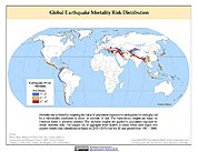
Global Earthquake Mortality Risks and Distribution
National Aeronautics and Space Administration —
The Global Earthquake Mortality Risks and Distribution is a 2.5 minute grid of global earthquake mortality risks. Gridded Population of the World, Version 3 (GPWv3)... -
University
Catron County Blocks, Age by 5-Year Age Groups for Females (2010)
Earth Data Analysis Center, University of New Mexico —
The once-a-decade decennial census was conducted in April 2010 by the U.S. Census Bureau. This count of every resident in the United States was mandated by Article I,... -
Federal
Social Vulnerability Index (SoVI) for Wisconsin based on 2000 Census Block Groups
National Oceanic and Atmospheric Administration, Department of Commerce —
This data depicts the social vulnerability of Wisconsin census block groups to environmental hazards. Data were culled primarily from the 2000 Decennial Census. -
Federal
Social Vulnerability Index (SoVI) for Georgia based on 2000 Census Block Groups
National Oceanic and Atmospheric Administration, Department of Commerce —
This data depicts the social vulnerability of Georgia census block groups to environmental hazards. Data were culled primarily from the 2000 Decennial Census. -
County
Total King County Population, 2000 - 2010
King County, Washington —
King County Population, 2010 U.S. Census; Source: US Census 2010, PL94-171 redistricting file, February 2011 -
State
Maryland Historical and Projected Population by Jurisdiction
State of Maryland —
Population Projections for Maryland and the jurisdictions - historical population 1970-2010; projections out to 2040. Projections prepared by the Maryland Department...

Official websites use .gov
A
.gov website belongs to an official government
organization in the United States.
Secure .gov websites use HTTPS
A
lock (
) or https:// means you’ve safely connected to
the .gov website. Share sensitive information only on official,
secure websites.