

1,479 datasets found
-
Federal
Soda Lake Geothermal: Raw 3D and 3C Seismic-Reflection Data from 2010 Survey
Department of Energy —
This dataset contains seismic-reflection records created in 2010 around the Soda Lake geothermal field near Fallon, Nevada. The data was collected by the power plant... -
Federal
Instructions for Downloading Brady Seismic Network Raw Waveform Data from NCEDC
Department of Energy —
Links and instructions for downloading Brady's triggered seismic network waveform data from the Northern California Earthquake Data Center (NCEDC). Data from... -
Federal
Areas with Surface Thermal Anomalies as Detected by ASTER and LANDSAT Data around South Canyon Hot Springs, Garfield County, Colorado
Department of Energy —
This map shows areas of anomalous surface temperature around South Canyon Hot Springs as identified from ASTER and LANDSAT thermal data and spatial based insolation... -
Federal
Effectiveness of Shallow Temperature Surveys to Target a Geothermal Reservoir at Previously Explored Site at McGee Mountain, Nevada: Final Report for U.S. Department Of Energy Grant EE-0002830
Department of Energy —
The McGee Mountain geothermal area was selected to test early-stage shallow temperature survey techniques and drill two slim holes to test the resource. Geothermal... -
Federal
January 2014 Dixie Valley Binary Cycle Production Data
Department of Energy —
Dixie Valley production data for January 2014, for a DOE Report. Used to demonstrate the techno-economic feasibility of utilizing the available unused heat to... -
Federal
Utah FORGE: Geothermal Resource Assessment Report 2024
Department of Energy —
This report provides a first-order assessment of the producible energy from the Utah FORGE EGS reservoir, based on stimulation and circulation testing in 2024. The... -
Federal
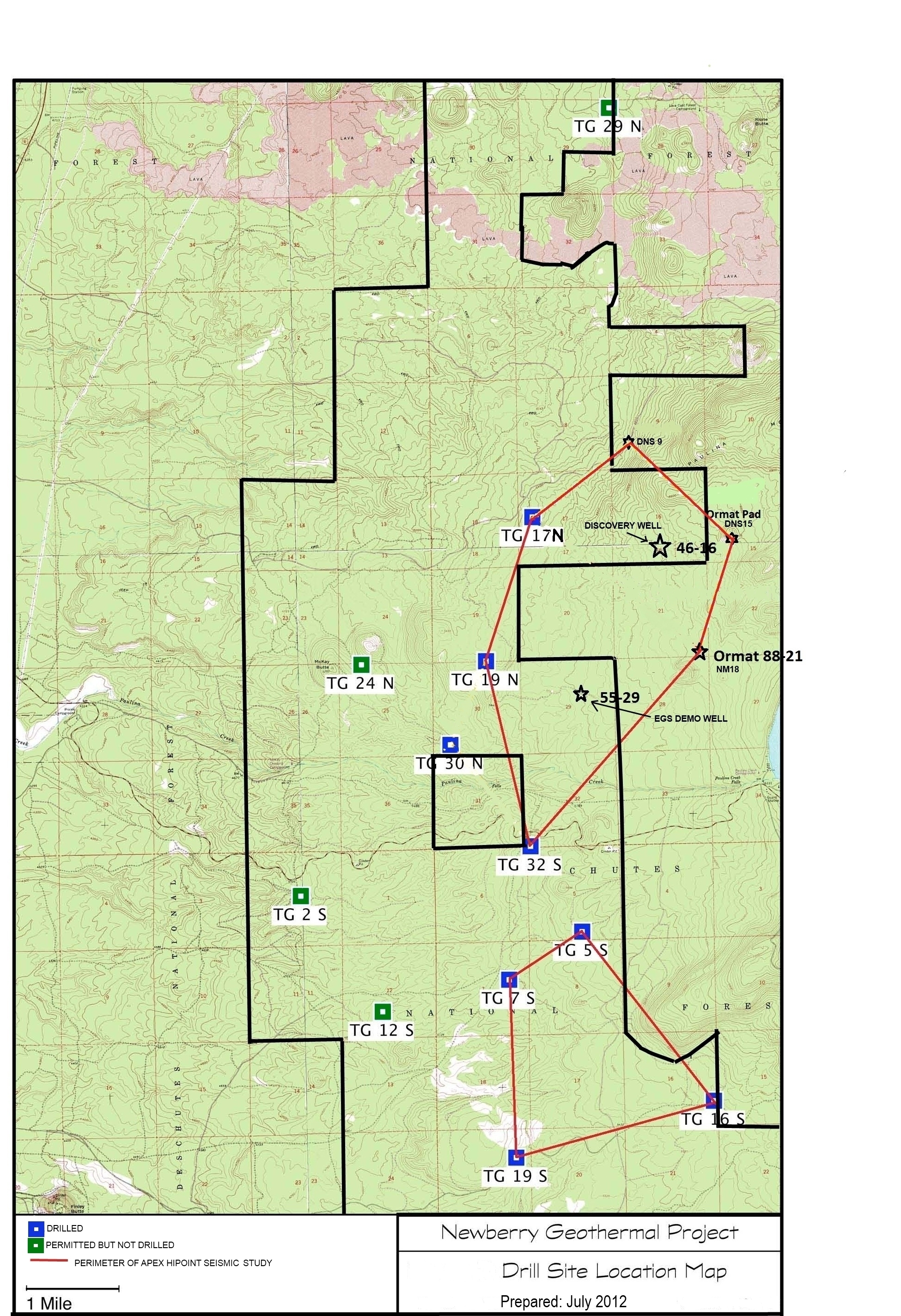
Map of Validation of Innovative Exploration Technologies for Newberry Volcano
Department of Energy —
A map showing location of wells permitted, drilled and seismic test, as part of validation of innovative exploration technologies done for the Newberry Volcano... -
Federal
Rare Earth Element Geochemistry for Produced Waters, WY
Department of Energy —
These data represent major, minor, trace, isotopes, and rare earth element concentrations in geologic formations and water associated with oil and gas production.... -
Federal
LiDAR, Granite Springs Valley, Nevada Play Fairway Analysis
Department of Energy —
This data is associated with the Nevada Play Fairway project and contains the entire package of LiDAR data for Granite Springs Valley. -
Federal
Brady's Geothermal Field Seismic Network Metadata
Department of Energy —
Brady's geothermal field seismic network station locations and dates of operation. -
Federal
Henrys Fork near Ashton, ID (YHEN)
Department of the Interior —
Henrys Fork near Ashton, Idaho (YHEN) Sample Collection: Samples were collected near the USGS stream gage 13046000 (Latitude 44°04'11", Longitude 111°30'38" NAD83).... -
Federal
Utah FORGE: Well Data for Student Competition
Department of Energy —
Well 58-32 (previously labeled MU-ESW1) was drilled near Milford Utah during Phase 2B of the FORGE Project to confirm geothermal reservoir characteristics met... -
Federal
Matlab Scripts and Sample Data Associated with Water Resources Research Article
Department of Energy —
Scripts and data acquired at the Mirror Lake Research Site, cited by the article submitted to Water Resources Research: Distributed Acoustic Sensing (DAS) as a... -
Federal
Utah FORGE 2-2446: Closing the Loop Between In-Situ Stress Complexity and EGS Fracture Complexity - 2024 Annual Workshop Presentation
Department of Energy —
This is a presentation on Closing the Loop Between In-Situ Stress Complexity and EGS Fracture Complexity by Lawrence Livermore National Laboratory, presented by... -
Federal
Economic Impact of Permitting Timelines on Produced Geothermal Power
Department of Energy —
Despite having a large geothermal power potential in the United States, only a small fraction has been developed for power generation. Various barriers, including... -
State
Geologic Database of Information on Volcanoes in Alaska (GeoDIVA)
State of Alaska —
Geologic Database of Information on Volcanoes in Alaska (GeoDIVA), Digital Data Series 20, is the enterprize database that serves as the back-end to AVO's public and... -
Federal
Seismic Survey 2016 Metadata at San Emidio, Nevada
Department of Energy —
1301 Vertical Component seismic instruments were deployed at San Emidio Geothermal field in Nevada in December 2016. The first record starts at... -
Federal
Preliminary Geologic Map of the Tuscarora Geothermal Area, Elko County, Nevada
Department of Energy —
Preliminary geologic map, unit descriptions, and cross-sections of the Tuscarora geothermal area. The files within the zip are all in pdf format. The the two maps...
1,479 datasets found