
-
Federal
RLC Forest Stand Carbon Map of Russia
National Aeronautics and Space Administration —
This dataset is a 1:15 million scale map of forest stand carbon for the land area of Russia (Stone et al., 2000). The objective was to create a first approximation of... -
Federal
Rock glaciers, Prealps, Vaud, Switzerland, Version 1
National Aeronautics and Space Administration —
The investigated area forms part of the western lobe of the Prealps (Swiss Prealps). The 25 identified fossil rock glaciers are found mainly in the Prealpes medianes... -
Federal
Pre-Delta-X: AVIRIS-derived Total Suspended Solids Maps for MRD, LA, USA, 2015-2016
National Aeronautics and Space Administration —
This dataset includes total suspended solids (TSS) at the water surface across the Atchafalaya and Terrebonne Basins in Southern Louisiana, USA, within the... -
Federal
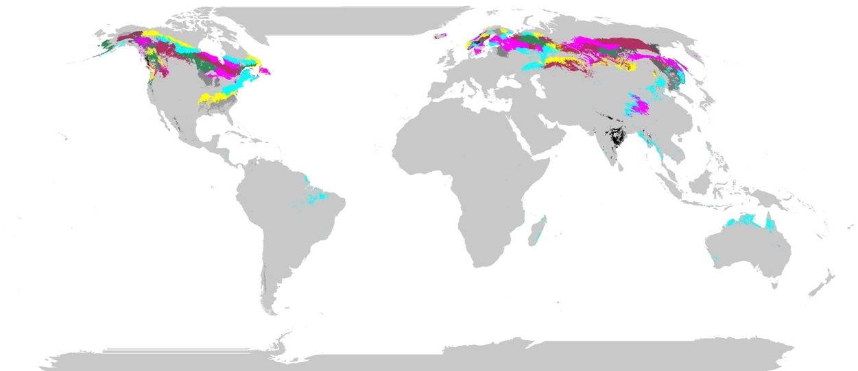
Phenoregions For Monitoring Vegetation Responses to Climate Change
National Aeronautics and Space Administration —
The overall purpose in this research was to identify the regions of the world best suited for long-term monitoring of biospheric responses to climate change, i.e.... -
Federal
SAFARI 2000 Plant and Soil C and N Isotopes, Southern Africa, 1995-2000
National Aeronautics and Space Administration —
This data set contains measurements of the concentration and stable carbon (13C / 12C) and nitrogen (15N / 14N) isotope ratios of plant (leaves, roots and fungi) and... -
Federal
SAFARI 2000 AERONET Ground-based Aerosol Data, Dry Season 2000
National Aeronautics and Space Administration —
AERONET (AErosol RObotic NETwork) is an optical ground-based aerosol monitoring network and data archive system. AERONET measurements of the column-integrated aerosol... -
Federal
Polar Radiant Energy in the Far InfraRed Experiment (PREFIRE) Satellite 2 Cloud Mask R01
National Aeronautics and Space Administration —
Polar Radiant Energy in the Far InfraRed Experiment (PREFIRE) Satellite 2 Cloud Mask (PREFIRE_SAT2_2B-MSK) contains a binary clear/cloud indicator and probabilities... -
Federal
Project Birdseye Aerial Photograph Collection, 1970 - 1984, Version 1
National Aeronautics and Space Administration —
This collection consists of both analog and digital aerial photographs from Arctic areas in and around Baffin Bay, the Labrador Sea, the Arctic Ocean, the Beaufort... -
Federal
SEAC4RS ER-2 Aircraft In-Situ Meteorological and Navigational Data
National Aeronautics and Space Administration —
SEAC4RS_MetNav_AircraftInSitu_ER2_Data are in-situ meteorological and navigational data collected onboard the ER-2 aircraft during the Studies of Emissions and... -
Federal
Sentinel-1C Single Polarization High Resolution Ground Range Detected Product Metadata
National Aeronautics and Space Administration —
The Sentinel-1C satellite was launched December 5, 2024. Sentinel-1C is the the latest satellite to be added to the Sentinel-1 constellation. The Sentinel-1... -
Federal
Sentinel-1C Dual Polarization High Resolution Ground Range Detected Product
National Aeronautics and Space Administration —
The Sentinel-1C satellite was launched December 5, 2024. Sentinel-1C is the the latest satellite to be added to the Sentinel-1 constellation. The Sentinel-1... -
Federal
Sentinel-1C Dual Polarization Medium Resolution Ground Range Detected Product
National Aeronautics and Space Administration —
The Sentinel-1C satellite was launched December 5, 2024. Sentinel-1C is the the latest satellite to be added to the Sentinel-1 constellation. The Sentinel-1... -
Federal
SENTINEL-1A_DUAL_POL_GRD_MEDIUM_RES
National Aeronautics and Space Administration —
Sentinel-1A Dual-pol ground projected medium resolution images -
Federal
Sentinel-1 Interferograms - Coherence
National Aeronautics and Space Administration —
Sentinel-1 SLC interferometric products generated by JPL using ISCE v2.0.0, delivered by ASF -
Federal
SCOAPE Pandora Column Observations
National Aeronautics and Space Administration —
SCOAPE_Pandora_Data is the column NO2 and ozone data collected by Pandora spectrometers during the Satellite Coastal and Oceanic Atmospheric Pollution Experiment... -
Federal
SEDIMENT ANALYSIS NETWORK FOR DECISION SUPPORT (SANDS) LANDSAT GEOTIFF V1
National Aeronautics and Space Administration —
The Sediment Analysis Network for Decision Support (SANDS) Landsat Geotiff dataset includes images for sediment redistribution after a hurricane on the coast of the... -
Federal
ABoVE: AVHRR-Derived Forest Fire Burned Area-Hot Spots, Alaska and Canada, 1989-2000
National Aeronautics and Space Administration —
This dataset provides annual forest fire burned area and daily hotspot products developed using data acquired from the Advanced Very-High-Resolution Radiometer... -
Federal
MLS/Aura L1 Radiances from Filter Banks for THz V004 (ML1RADT) at GES DISC
National Aeronautics and Space Administration —
ML1RADT is the EOS Aura Microwave Limb Sounder (MLS) product containing the level 1 radiances from the filter banks for the GHz radiometers. The data version is 4.2.... -
Federal
MISR Level 3 FIRSTLOOK Global Cloud public Product in netCDF covering a day V002
National Aeronautics and Space Administration —
MI3DCDNF_002 is the Multi-angle Imaging SpectroRadiometer (MISR) Level 3 FIRSTLOOK Global Cloud public Product in netCDF covering a day version 2. It contains the... -
Federal
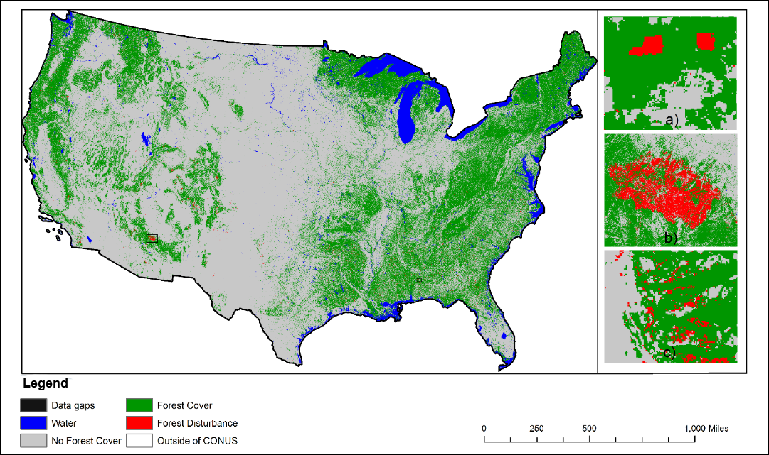
NACP NAFD Project: Forest Disturbance History from Landsat, 1986-2010
National Aeronautics and Space Administration —
The North American Forest Dynamics (NAFD) products provided in this data set consist of 25 annual and two time-integrated forest disturbance maps for the conterminous...

Official websites use .gov
A
.gov website belongs to an official government
organization in the United States.
Secure .gov websites use HTTPS
A
lock (
) or https:// means you’ve safely connected to
the .gov website. Share sensitive information only on official,
secure websites.