
-
Federal
Joint Global Ocean Flux Study (JGOFS)
National Aeronautics and Space Administration —
Measurements from the Joint Global Ocean Flux Study (JGOFS), spanning 1986 to 1998. -
Federal
IceBridge Mission Flight Reports, Version 1
National Aeronautics and Space Administration —
This data set contains flight reports from NASA Operation IceBridge Greenland, Arctic, Antarctic, and Alaska missions. Flight reports contain information on region,... -
Federal
LBA-ECO CD-10 CO2 and H2O Eddy Flux Data at km 67 Tower Site, Tapajos National Forest
National Aeronautics and Space Administration —
This data set reports eddy flux measurements of CO2 and H2O exchange and associated meteorological measurements at the Para Western (Santarem) - km 67, Primary Forest... -
Federal
ISLSCP II Global Primary Production Data Initiative Gridded NPP Data
National Aeronautics and Space Administration —
Net Primary Production (NPP) is an important component of the carbon cycle and, among the pools and fluxes that make up the cycle, it is one of the steps that are... -
Federal
GPM MHS on METOP-B (GPROF) Climate-based Radiometer Precipitation Profiling L2A 1.5 hours 17 km V07 (GPM_2AGPROFMETOPBMHS_CLIM) at GES DISC
National Aeronautics and Space Administration —
Version 07 is the current version of the data set. Older versions are no longer available and have been superseded by Version 07. The "CLIM" products differ from... -
Federal
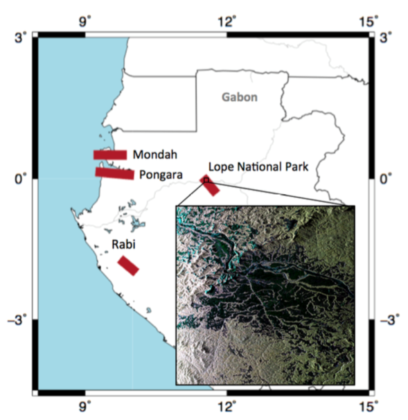
AfriSAR: Canopy Cover and Vertical Profile Metrics Derived from LVIS, Gabon, 2016
National Aeronautics and Space Administration —
This dataset includes footprint-level canopy structure products derived from data collected using NASA's Land, Vegetation, and Ice Sensor (LVIS) during flights over... -
Federal
AfriSAR: Canopy Structure Derived from PolInSAR and Coherence TomoSAR NISAR tools
National Aeronautics and Space Administration —
This dataset contains forest vertical structure and associated uncertainty products derived by applying multi-baseline Polarimetric Interferometric Synthetic Aperture... -
Federal
ASTER L2 Surface Radiance VNIR and SWIR V003
National Aeronautics and Space Administration —
The Terra Advanced Spaceborne Thermal Emission and Reflection Radiometer (ASTER) Surface Radiance VNIR and SWIR (AST_09) is a multi-file product that contains... -
Federal
Digital SAR Mosaic and Elevation Map of the Greenland Ice Sheet, Version 1
National Aeronautics and Space Administration —
The Digital SAR Mosaic and Elevation Map of the Greenland Ice Sheet combines the most detailed synthetic aperture radar (SAR) image mosaic available with the best... -
Federal
TRACER-AQ Pandora Column Observations
National Aeronautics and Space Administration —
TRACERAQ_Pandora_Data is the Pandora spectrometer data collected at various ground sites during the TRacking Aerosol Convection ExpeRiment – Air Quality (TRACER-AQ)... -
Federal
VIIRS/NPP Leaf Area Index/FPAR 8-Day L4 Global 500m SIN Grid V001
National Aeronautics and Space Administration —
The VNP15A2H VIIRS Version 1 data product was decommissioned on April 8th, 2025. Users are encouraged to use Version 2 data products, which provideFederalVIIRS/NPP Moderate Resolution Terrain-Corrected Geolocation L1 6-Min Swath 750m NRT
National Aeronautics and Space Administration —
The VNP03MOD_NRT, a Near Real Time (NRT) product, includes the geolocation fields that are calculated for each VIIRS moderate resolution band (M-band) Line of sight...FederalVegetation Index and Phenology (VIP) Phenology EVI-2 Yearly Global 0.05Deg CMG V004
National Aeronautics and Space Administration —
The NASA Making Earth System Data Records for Use in Research Environments (MEaSUREs)...FederalVIIRS/NPP BRDF/Albedo Valid Observation Band M2 Daily L3 Global 30ArcSec CMG V001
National Aeronautics and Space Administration —
The VNP43D43 Version 1 data product was decommissioned on July 31, 2025. Users are encouraged to use theFederalVIIRS/NPP Hourly Cumulative Gridded Day Night Band 500m Linear Lat Lon Grid Night NRT
National Aeronautics and Space Administration —
The Near Real Time (NRT) Suomi National Polar-Orbiting Partnership (S-NPP) NASA Visible Infrared Imaging Radiometer Suite (VIIRS) hourly top-of-atmosphere, at-sensor...FederalUnderstory Vegetation Biomass from Selected Burned and Unburned sites in Alaska
National Aeronautics and Space Administration —
This dataset provides measurements of vegetation biomass from 11 locations across Alaska during 2016 to 2018. Vegetation was harvested from plots that were located at...FederalVIIRS/NPP BRDF/Albedo Parameter 2 Band M7 Daily L3 Global 30 ArcSec CMG V001
National Aeronautics and Space Administration —
The VNP43D17 Version 1 data product was decommissioned on July 31, 2025. Users are encouraged to use theFederalVIIRS/NPP Land Surface Temperature/Emissivity Monthly L3 Global 0.05Deg CMG V002
National Aeronautics and Space Administration —
The NASA/NOAA Suomi National Polar-orbiting Partnership (Suomi NPP) Visible Infrared Imaging Radiometer Suite (VIIRS) Land Surface Temperature and Emissivity...FederalVIIRS/NPP Land Surface Temperature/Emissivity Daily L3 Global 0.05Deg CMG V002
National Aeronautics and Space Administration —
The NASA/NOAA Suomi National Polar-orbiting Partnership (Suomi NPP) Visible Infrared Imaging Radiometer Suite (VIIRS) Land Surface Temperature and Emissivity...FederalVIIRS/NOAA20 Cloud Mask and Spectral Test Results 6-Min L2 Swath 750m
National Aeronautics and Space Administration —
The VIIRS/NOAA20 Cloud Mask and Spectral Test Results 6-Min L2 Swath 750m product Mask is one of three continuity products designed to sustain the long-term records...9,607 datasets found

Official websites use .gov
A
.gov website belongs to an official government
organization in the United States.
Secure .gov websites use HTTPS
A
lock (
) or https:// means you’ve safely connected to
the .gov website. Share sensitive information only on official,
secure websites.