

628 datasets found
-
Federal
Digital Shoreline Analysis System version 4.3 Transects with Short-Term Linear Regression Rate Calculations for southern North Carolina (NCsouth)
Department of the Interior —
Sandy ocean beaches are a popular recreational destination, often surrounded by communities containing valuable real estate. Development is on the rise despite the... -
Federal
JPEG images of boomer seismic data from back-barrier research cruise 2003-005-FA collected by the U.S. Geological Survey
Department of the Interior —
The northeastern North Carolina coastal system, from False Cape, Virginia, to Cape Lookout, North Carolina, has been studied by a cooperative research program that... -
Federal
Boomer seismic tracklines from USGS cruise 2004-006-FA from Pamlico Sound, North Carolina (bbb2004006_tracklines.shp)
Department of the Interior —
The northeastern North Carolina coastal system, from False Cape, Virginia, to Cape Lookout, North Carolina, has been studied by a cooperative research program that... -
Federal
JPEG images of chirp seismic data from back-barrier research cruise 2003-005-FA collected by the U.S. Geological Survey
Department of the Interior —
The northeastern North Carolina coastal system, from False Cape, Virginia, to Cape Lookout, North Carolina, has been studied by a cooperative research program that... -
Federal
JPEG images of chirp seismic data from back-barrier research cruise 2004-005-FA collected by the U.S. Geological Survey
Department of the Interior —
The northeastern North Carolina coastal system, from False Cape, Virginia, to Cape Lookout, North Carolina, has been studied by a cooperative research program that... -
Federal
Shot navigation for North Carolina barrier island ground penetrating radar collected by East Carolina University in 2005 (ilgpr2005_shots.shp)
Department of the Interior —
The northeastern North Carolina coastal system, from False Cape, Virginia, to Cape Lookout, North Carolina, has been studied by a cooperative research program that... -
Federal
JPEG images of boomer seismic data from back-barrier research cruise 2001-013-FA collected by the U.S. Geological Survey
Department of the Interior —
The northeastern North Carolina coastal system, from False Cape, Virginia, to Cape Lookout, North Carolina, has been studied by a cooperative research program that... -
Federal
DCpts, DTpts, SLpts: Dune crest, dune toe, and mean high water shoreline positions: Cape Lookout, NC, 2014
Department of the Interior —
Understanding how sea-level rise will affect coastal landforms and the species and habitats they support is critical for crafting approaches that balance the needs of... -
Federal
ElevMHW: Elevation adjusted to local mean high water: Cape Lookout, NC, 2014
Department of the Interior —
Understanding how sea-level rise will affect coastal landforms and the species and habitats they support is critical for crafting approaches that balance the needs of... -
County
Morrisville Zoning
Wake County —
Morrisville Zoning. More information: https://www.townofmorrisville.org/government/departments-services/planning -
Federal
0.3 meter backscatter JPEG image (with world file) of the nearshore seafloor off of Avalon Beach, NC (mosaic4.jpg, UTM Zone 18N, WGS84)
Department of the Interior —
The northeastern North Carolina coastal system, from False Cape, Virginia, to Cape Lookout, North Carolina, has been studied by a cooperative research program that... -
Federal
SIR2005-5073_CBRWM_LandSegments
Department of the Interior —
This data set is an ArcGIS shapefile depicting land segments in the Chesapeake Bay Watershed and adjacent states of New York, Pennsylvania, Maryland, West Virginia,... -
Federal
National Assessment of Oil and Gas Project - East Coast Mesozoic Basins of the Piedmont, Blue Ridge Thrust Belt, Atlantic Coastal Plain, and New England Provinces Assessment Units
Department of the Interior —
The Assessment Unit is the fundamental unit used in the National Assessment Project for the assessment of undiscovered oil and gas resources. The Assessment Unit is... -
Federal
JPEG images of boomer seismic data from back-barrier research cruise 2004-006-FA collected by the U.S. Geological Survey
Department of the Interior —
The northeastern North Carolina coastal system, from False Cape, Virginia, to Cape Lookout, North Carolina, has been studied by a cooperative research program that... -
Federal
National Assessment of Oil and Gas Project - Appalachian Basin (067) Quarter-Mile Cells
Department of the Interior —
Cell maps for each oil and gas assessment unit were created by the USGS as a method for illustrating the degree of exploration, type of production, and distribution... -
Federal
Sidescan sonar navigation from USGS cruise 2003-003-FA along the inner continental shelf of northern North Carolina (iss2003003_tracklines.shp)
Department of the Interior —
The northeastern North Carolina coastal system, from False Cape, Virginia, to Cape Lookout, North Carolina, has been studied by a cooperative research program that... -
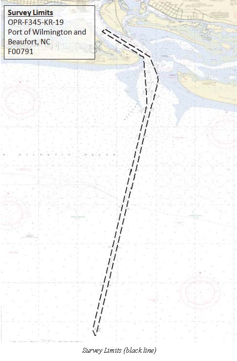
Federal
F00791: NOS Hydrographic Survey , 2019-09-09
National Oceanic and Atmospheric Administration, Department of Commerce —
The National Oceanic and Atmospheric Administration (NOAA) has the statutory mandate to collect hydrographic data in support of nautical chart compilation for safe... -
Federal
TIGER/Line Shapefile, Current, State, North Carolina, State Legislative District (SLD) Lower Chamber
U.S. Census Bureau, Department of Commerce —
This resource is a member of a series. The TIGER/Line shapefiles and related database files (.dbf) are an extract of selected geographic and cartographic information... -
Federal
TIGER/Line Shapefile, 2024, State, North Carolina, NC, State Legislative District (SLD) Upper Chamber
U.S. Census Bureau, Department of Commerce —
The TIGER/Line shapefiles and related database files (.dbf) are an extract of selected geographic and cartographic information from the U.S. Census Bureau's Master...
628 datasets found